Tag Archives: Planning

Urban Patterns | Ragusa, Sicily in Italy

“Can we move to Italy?
Meet me by the church up high on the hill.”
Italy, Julia Fordham

Urban Patterns | Ragusa, Sicily, Italy
by Dr. Mark David Major, AICP, CNU-A

To many people, Ragusa, Sicily in Italy represents the prototypical Italian hilltop village lying below the Hyblaean Mountains. It is listed on the UNESCO World Heritage Sites. The origins of the oldest part of the town on a 300-meter (980 feet) high hilltop (upper town to the right, below) lying between two valleys can be traced to the 2nd Millennium BC, i.e. more than 3,000 years ago. The ancient city came into contact with nearby Greek colonies and grew due to the nearby port of Camerina. Following a short period of Carthaginian rule, it fell into the hands of the ancient Romans and the Byzantines, who fortified the city and built a large castle. Ragusa was occupied by the Arabs in 848 AD, remaining under their rule until the 11th century, when the Normans conquered it. Thereafter Ragusa’s history followed the events of the Kingdom of Sicily, created in the first half of the twelfth century (Source: Wikipedia).

Satellite view from 2 km of Ragusa, Sicily in Italy (Source: Google Earth).

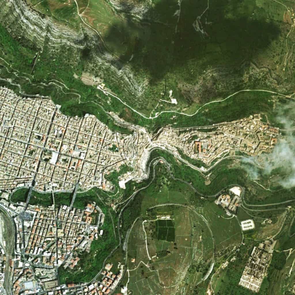
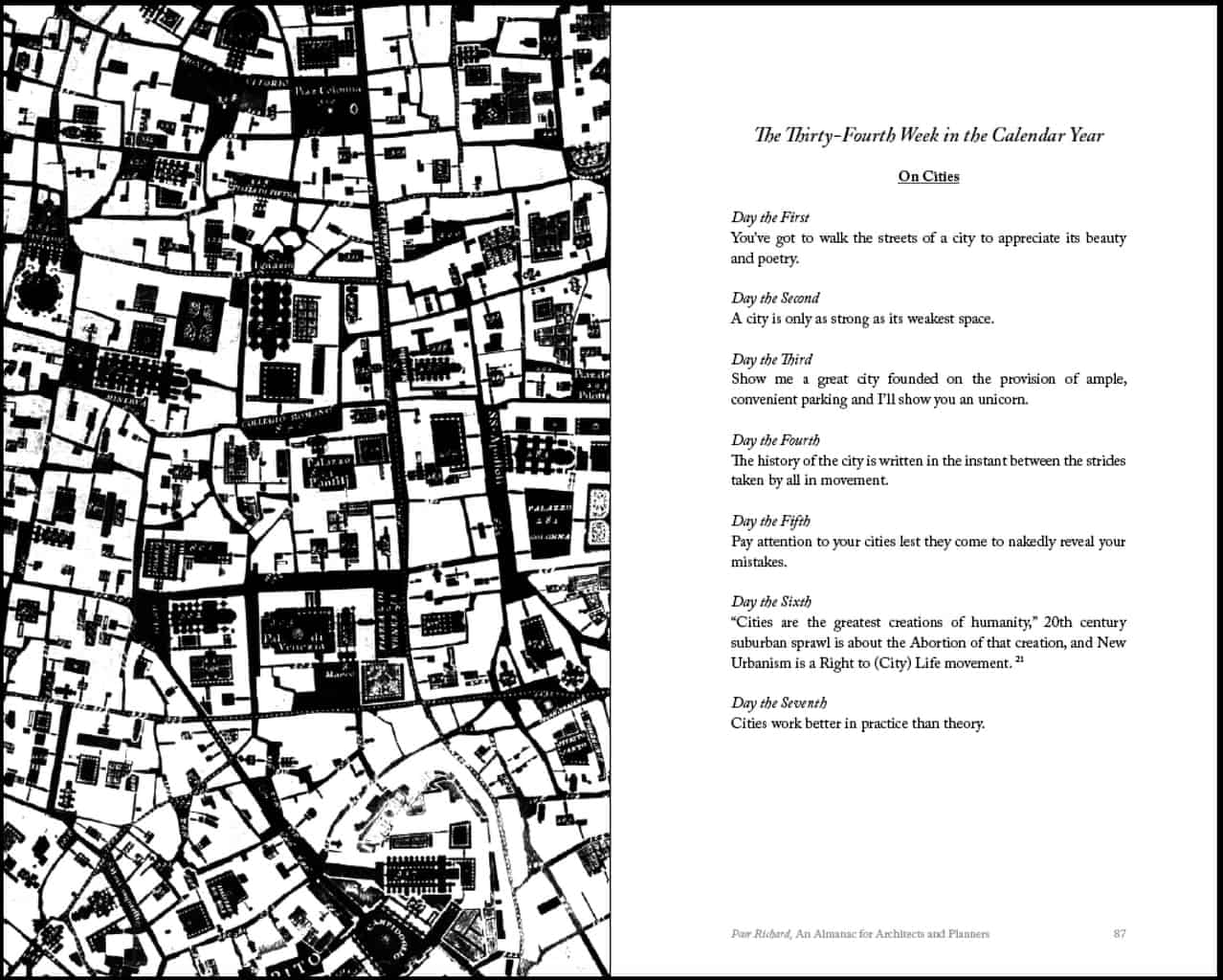
Upper town has a deformed grid layout where the street pattern conforms to the topography of the hill. This tends to make movement longer in terms of time and distance through upper town but changes in elevation are more gradual. This offers an excellent contrast to an urban pattern such as that found in San Francisco, where the regular grid layout enables movement through the layout to be shorter in terms of time and distance but changes in elevation tend to be much steeper. Together, Ragusa and San Francisco provide two models of how to incorporate acute topographical conditions within a settlement. The vertical construction of dwellings adapts to the topographical conditions of a local site in particular ways. In the case of San Francisco, this occurs by steeply adapting finished floors so they step up or down in section with the topography, which serves to maintain the conceptual logic of the regular grid imposed on the land. In Ragusa, the logic of the deformed grid in the town emerges from an apparently local process of aggregating dwelling units. During this aggregation process, finished floors are adapted to the contours of the topography so changes in finished floor elevation tend to be gradual instead of steep. In this way, the layout literally incorporates the acute topographical conditions into its functional pattern. This is why Moholy-Nagy (1968) describes such layouts as geomorphic. The street pattern of the newer areas adjacent to lower town (to the left, above) at the foot of the hill in the valley is a regular grid since the topography is less acute (e.g. more flat) at this location. The lower town also utilizes larger block sizes in its regular grid layout.

(Updated: April 11, 2017)

Urban Patterns is a series of posts from The Outlaw Urbanist presenting interesting examples of terrestrial patterns shaped by human intervention in the urban landscape over time.

Share the knowledge!
Share

Preview | Poor Richard | An Almanac for Architects and Planners

COMING IN APRIL 2013! POOR RICHARD, AN ALMANAC FOR ARCHITECTS AND PLANNERS BY MARK DAVID MAJOR, AICP

A high-resolution preview of the front cover is below.

The witticisms and sayings of Poor Richard are organized by calendar weeks, one generic theme per week, and a single saying for each day of the week – plus one for “years in the state of leaping” – adding up to a full calendar year. Each week of the calendar week is accompanied by a high contrast, black and white illustration designed or selected to get people thinking differently about cities. A high-resolution preview of “On Cities” for pages 86-87 with an accompanying illustration (inverted detail of the Nolli map of Rome presenting civic space in black and blocks in white) is below.

“On Cities” for the 34th Week in the Calendar Year on pages 86-86. Click on the image to see a high resolution version.


Poor Richard, An Almanac for Architects and Planners also includes a foreword by Julia Starr Sanford, a preface from the author, an Introduction incorporating the “Declaration of Planning Independence” previously published on The Outlaw Urbanist, bibliography and illustration credits, and an Afterword featuring The Outlaw Urbanist manifesto.

Poor Richard, An Almanac for Architects and Planners by Mark David Major, AICP, Foreword by Julia Starr Sanford, Forum Books, an Imprint of Carousel Productions, 136 pages, 5.0″ x 8″, $9.99 (in print); also available in eBook, format and price TBD.

Share the knowledge!
Share

MORESO | What Would Jesus Do | The Sermon on the Street

Blessings on the poorly connected street,
For they shall find a grid to call home.
Blessings on the street that suffers isolation,
For they shall find comfort in a family of streets.
Blessings on the meek street,
For they shall inherit the city’s fortunes.
Blessings on streets that hunger and thirst for righteous design,
For they shall be filled with people.
Blessings on the safe streets,
For they shall provide mercy to pedestrians.
Blessings on the richly connected streets,
For they shall become a city.
Blessings on the placemakers,
For they shall be called the children of the city.
Blessings on those who are persecuted because of righteous design,
For they shall one day live in a great city.
Blessings on you when people insult you, persecute you, and falsely say all kinds of evil against the city.
Rejoice and be glad because great are your rewards in the city, for in the same way they persecuted the prophets who were before you.
You are the salt of the Earth but if the salt loses its saltiness, how can it be made salty again? It is no longer good for anything, except to be thrown out and trampled over by the automobile.
You are the light of the city. A city built on a hill cannot be hidden. Neither do people light a lantern and hide it. Instead they put it on a post in the street, and it gives light to all pedestrians on that street. In the same way, let your city lights shine before others, that they may see your good streets and glorify the greatness of your city.

Moreso is a series of short ruminations or thoughts of the moment, usually of less than 500 words, from The Outlaw Urbanist.

Share the knowledge!
Share

Urban Patterns | Old Town Fernandina | Spanish Laws of the Indies

“Old Town, the girl’s a fool, she broke the rule…”
Old Town, Thin Lizzy

Urban Patterns | Old Town Fernandina | Spanish Laws of the Indies
by Dr. Mark David Major, AICP, CNU-A

Old Town Fernandina is located on the northern end of Amelia Island in Florida, immediately south of the border with the State of Georgia, and about 40 miles north of Downtown Jacksonville. Old Town Fernandina was the last Spanish settlement founded in North America based on the Laws of the Indies and, as such, is listed on the National Register of Historic Places. Old Town is located on an inlet to the St. Mary’s River and Amelia River from the Atlantic Ocean, which offered (and still does) a generous deep-water port on the Atlantic coast for fishing and trade. Fernandina Beach grew southward with the construction of the David Yulee cross-state railroad from Cedar Key-to-Fernandina Beach in 1861 so the center of retail/commercial activity in Fernandina Beach shifted to what is now called “Downtown Fernandina.” Downtown Fernandina is also listed on the National Register of Historic Places. Because of this, Old Town Fernandina is probably the ‘purest’ example of a town founded based on the Spanish Laws of Indies remaining in North America. Fort San Carlos used to be located to the west of Plaza San Carlos (open space on the left of Old Town) but two-thirds of the grounds on which the fort formerly sat has been lost due to soil erosion.

Satellite view of Old Town Fernandina in Fernandina Beach, Florida USA (Source: Google Earth).
1811 Plat of Old Town Fernandina, Florida.

The earliest plat for the town (north is to the left in the above image) shows a regular grid layout ‘fitted’ to the shape of the topography of this peninsula in 4 x 4 block layout (5 x 5 street layout). The topography interrupts this geometric logic at the southeast (above, upper right-hand corner) and the northwest (above, lower left-hand corner) though the plat clearly shows the intention to in-fill to the northwest at the water’s edge in order to generate rectangular lots. Instead of a central plaza, the plaza in Fernandina was shifted to the what would become the water’s edge after the ‘disappearance’ of San Carlos into the river at the western edge of the plan (above, bottom edge of the drawing). The layout of lots within each block is also interesting with larger lots ‘internalized’ within the blocks and smaller lots ‘externalized’ along the eastern and western edges of the blocks. The exception is lots on the northern and southern edges of the blocks (identified as #1 and #2 in this plan) immediately adjacent to the plaza.

(Updated: April 7, 2017)

Urban Patterns is a series of posts from The Outlaw Urbanist presenting interesting examples of terrestrial patterns shaped by human intervention in the urban landscape over time.

Share the knowledge!
Share

Urban Patterns | Philadelphia, Pennsylvania USA

“Oh brother, are you gonna leave me,
Wastin´ away on the streets of Philadelphia.”
— Streets of Philadelphia, Bruce Springsteen

Urban Patterns | Philadelphia, Pennsylvania USA
by Dr. Mark David Major, AICP, CNU-A

Philadelphia is the largest city in the Commonwealth of Pennsylvania and the fifth-most populous city in the United States, with an estimated population of 1,567,442 and more than 6 million in the seventh-largest metropolitan statistical area, as of 2015. Philadelphia is the economic and cultural anchor of the Delaware Valley—a region located in the Northeastern United States at the confluence of the Delaware and Schuylkill rivers with 7.2 million people residing in the eighth-largest combined statistical area in the United States. In 1682, William Penn, an English Quaker, founded the city to serve as capital of the Pennsylvania Colony. Philadelphia played an instrumental role in the American Revolution as a meeting place for the Founding Fathers of the United States, who signed the Declaration of Independence in 1776 and the Constitution in 1787 (Source: Wikipedia).

Satellite view from 5 km of Philadelphia, Pennsylvania USA (Source: Google Earth).

There are two remarkable yet seemingly contradictory things about the urban pattern in Philadelphia; in particular, within the bounds of William Penn’s original 1682 plan for the city. First, is the remarkable degree to which the plan has changed over more than 330 years of development. Most often, this has occurred through the manipulation of block sizes (upsizing and subdividing of urban blocks) even if the Vine Street Expressway (Interstate 676) and Delaware Expressway (Interstate 95) ringing the bounds of the original plan might, at first glance, draw the eye to these large-scale interventions. Second, is the remarkable degree to which the integrity of the original Penn plan for the city has endured literally thousands of small-scale interventions over more than 330 years of development. Taken together, this points to something even more remarkable, which is the instrumental power of the regular grid to be simultaneously flexible for and resilient to change over time.

(Updated: April 1, 2017)

Urban Patterns is a series of posts from The Outlaw Urbanist presenting interesting examples of terrestrial patterns shaped by human intervention in the urban landscape over time.

Share the knowledge!
Share