10 Blogs We’re Reading… well, keeping an eye on… by Dr. Mark David Major, AICP, CNU-A, The Outlaw Urbanist contributor
We say ‘reading’ but really it is ‘periodically checking in on’ because there is way too much content to keep up with everything on the web. We have over 30 newspapers and online journals from the United States and Europe alone bookmarked for daily review! The Outlaw Urbanist is backlogged over a year with interesting news articles we have saved for re-posting on the blog. We are only now (very slowly) beginning to diligently work our way through this backlog. In the meantime, we encourage you to visit these blogs (in no particular order).
1. Clusterfuck Nation by James Howard Kunstler
Now archived on www.kunstler.com but still worth a periodic visit. He is on Twitter but not much so you can follow @Jhkunstler.
4. The Pure Hands by Dr. Nick “Sheep” and Professor Ruth Dalton
You can follow Sheep on Twitter @sheepdalton and Ruth @Ruth_C_Dalton. He is on Twitter more often than her.
7. Spatial Disjunctures by David Jeevendrampillai
(UCL Research Student whose blog has gone quiet for over a year but we hope returns soon)
8. Urban Formation or Mapping Urban Form and Society by Dr. Laura Vaughan
Professor of Urban Form and Society at UCL, whose blog has also gone quiet for six months… we’re all very busy these days. Laura tends to be on Twitter more than most and she often actively engages in interesting discussions via her feed @urban_formation.
10. Urbanism Speakeasy by Andy Boenau
We’re not sure if this qualifies as a blog since it is a podcast series… perhaps an audio blog. Andy is a active participant on Twitter @Boenau.
Purchase your copy of Poor Richard, Another Almanac for Architects and Planners (Volume 2) today!
Available in print from Amazon, CreateSpace, and other online retailers.
My ‘Secret’ Life as an Anonymous Source by Dr. Mark David Major, AICP, CNU-A, The Outlaw Urbanist contributor
Sorry, this post is quirky and not nearly as salacious as the title might suggest otherwise. However, enough time has passed (15 years) that I can now reveal one of the more interesting episodes in my professional career. This is my ‘secret’ life as an anonymous source for the free-wheeling British press involving a story about London Transport, the Metropolitan Police and, ultimately, the British Prime Minister Tony Blair and his still-young-at-the-time Labour government.
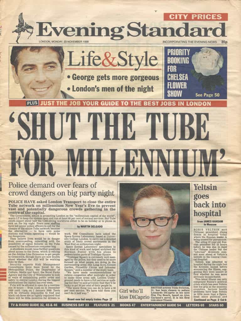
On November 23, 1998, London’s Evening Standard printed a front-page article by Martin Delgado with the screaming headline “SHUT THE TUBE FOR MILLENNIUM.” The story was about London Transport’s public claims that they would operate between 70% and 80% of the London Underground services for the Millennium New Year’s Eve celebration on December 31, 1999. However, as part of the crowds study group, London Transport was privately reporting they would be lucky to run services at 50% capacity on the night. At the time, there was a three-year crowds study group tasked with preparing Central London for the large number of people expected to attend the celebrations consisting of the Metropolitan Police, London Transport, Department of Culture, Media and Sport, City of Westminster, and their consultants Risk Management Consultants and Space Syntax Ltd.
Front cover of the 23 November 1998 issue of the Evening Standard.
The London Metropolitan Police was extremely concerned about London Transport’s plans to operate at only 50% capacity on the night and leaked the story to the Evening Standard. Delgado’s story quoted an anonymous source in Space Syntax Ltd. to support the position of the Metropolitan Police.
I was the anonymous source.
As I recall, a crowds study group member of the Metropolitan Police referred Mr. Delgado to me to support their position by providing some background information about the study. It was only years later that learned my mistake was asking for an “off the record” conversation ; not realizing this meant I could still be quoted as an anonymous source. In hindsight, I should have asked for a conversation “on background.” Oh well, live and learn. Initially, I took some grief inside Space Syntax for my role in this story but less than you might think because what I said was accurate and correct. The reaction inside Space Syntax about my role later evolved into bewildered amusement because of what next happened.
The story briefly caused a firestorm, which required Tony Blair to respond to Ministers of Parliament during Prime Minister’s Question Time. The story eventually led to the Labour government making wholesale changes to government preparations by refocusing the Millennium celebrations on the River Thames. This was not our idea but it was a darn good one in hindsight because it helped to spread the expected crowds over a much larger area of central London. A change that also required London Underground to operate nearer to full capacity on the night since people would be arriving and leaving via more underground stations. At the time, the concern of crowds study group about this change was our crowd observations were focused around Trafalgar Square, Leicester Square, and Piccadilly Circus on New Year’s Eve in 1996, 1997 and 1998.
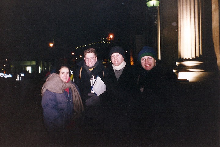
1:00 am, January 1, 1999 outside Canada House in Trafalgar Square after (very cold) New Year’s Eve crowd observations (from left to right): Beatriz Campos, François Dufaux, Mark David Major, and Tim Stonor.
We worried about missing something since we could not observe crowd movement and space use under the same circumstances before the actual night. However, the Millennium celebrations were a great success, going off without a hitch other than some minor incidents involving stupidity and chance, with no serious injuries due to overcrowding on the streets of central London. I like to think Space Syntax’s role as a consultant on the crowds study – and mine, in particular, as the Space Syntax project manager and anonymous source to this Evening Standard story – helped to ensure public safety on December 31, 1999.
If you are interested in more details about our crowds study, you can read about it here:
Major MD, A. Penn , G. Spiliopoulou, N. Spende, M. Doxa, and P. Fong, 2000, ‘Following the Crowd: Spatial Layout and Crowd Behaviour’, arq Architectural Research Quarterly, Volume 4, Number 3, Cambridge University Press, pp. 257-264, ISBN 0-521-79412-9.
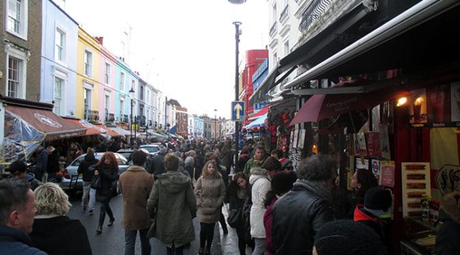
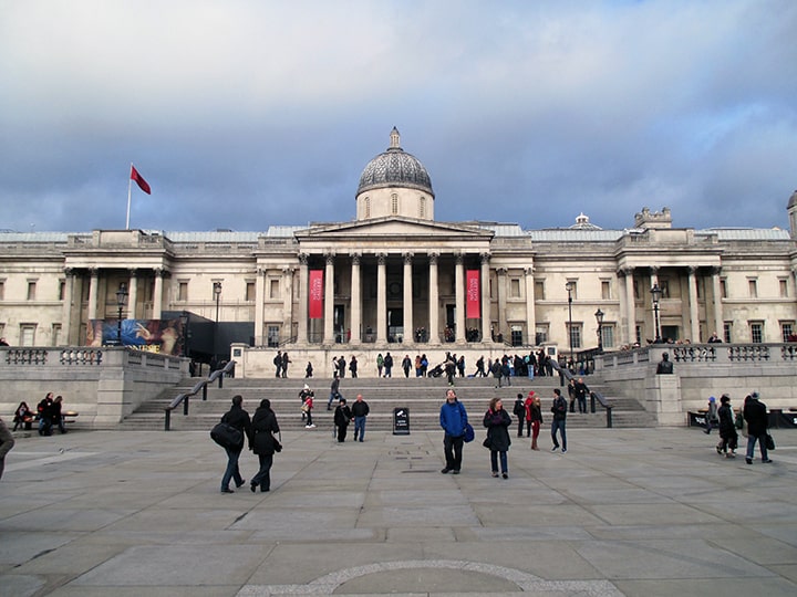
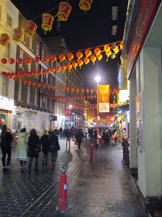
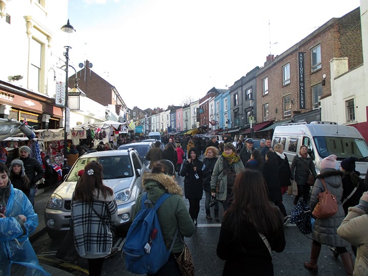
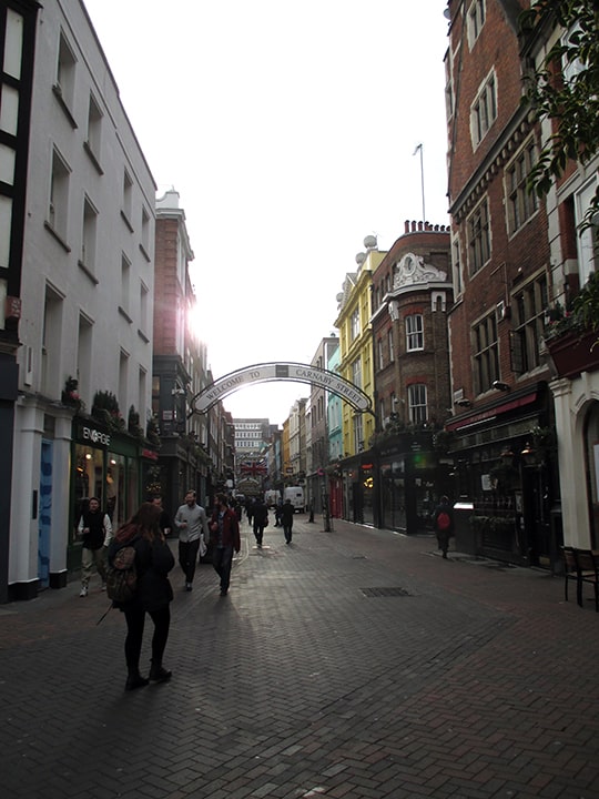
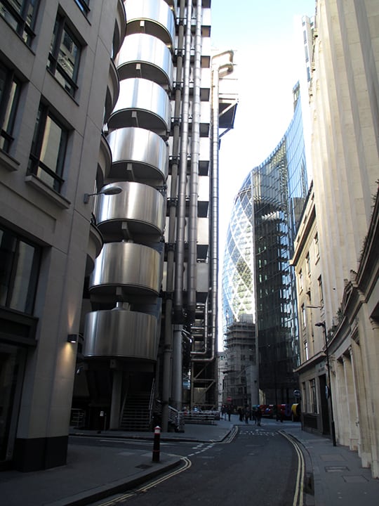
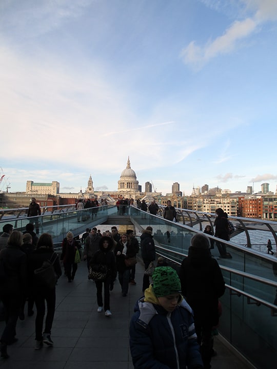
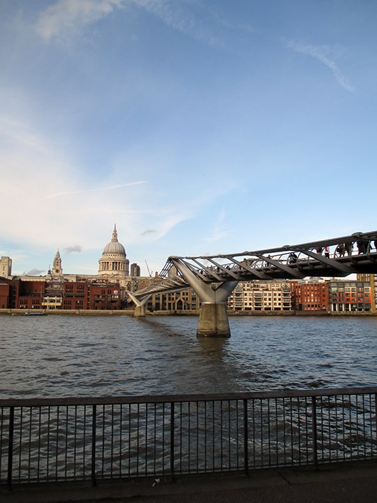
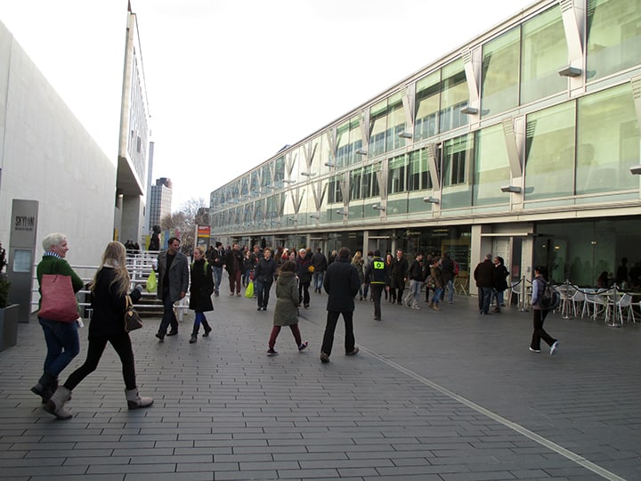
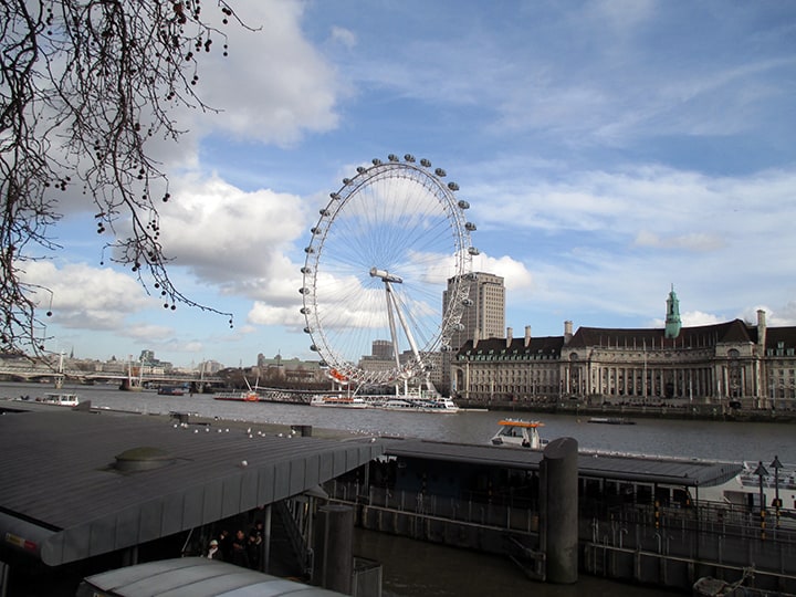
Remodeled steps into Trafalgar Square and pedestrianized area in front of the National Gallery, London (Image: Mark David Major).Gerrard Street in Chinatown at night in the West End, London (Image: Mark David Major).The street ballet looking north at the Portobello Road Market in Notting Hill, London (Image: Mark David Major).Carnaby Street in the West End on an early Monday morning (Image: Mark David Major).Looking north along the Lime Street line of sight (just sneaking through) pass Lloyds of London (by Lord Richard Rogers) to the Gherkin (by Lord Norman Foster) in the City of London (Image: Mark David Major).Millennium (or Bankside) Bridge by Lord Norman Foster looking north towards St. Paul’s Cathedral and the City of London (Image: Mark David Major).Millennium (or Bankside) Bridge by Lord Norman Foster from the south embankment. A London landmark that might not exist if it weren’t for space syntax analysis (Image: Mark David Major).Part of the remodeled South Bank Centre. The building adjacent and running parallel to the Charing Cross railroad tracks (to the right) would not exist if it weren’t for space syntax analysis of pedestrian movement patterns in the area (Image: Mark David Major).View east along the River Thames in London. The London Eye is to the right. Returning to London nearly 15 years later, I was pleasantly surprised by the amount of life on the river (Image: Mark David Major).
Space Syntax for Dummies, Part 3 RESULTS by Dr. Mark David Major, AICP, CNU-A, The Outlaw Urbanist contributor
The final part of this three-part introduction to the basics of space syntax reviews some of the earliest – and most crucial – research results about pedestrian and vehicular movement using the axial map (see above) of urban street networks. Again, Part 3 is somewhat tailored to an American audience since it is based on excerpts from Chapter 3 of my forthcoming Relentless Magnificence: The American Urban Grid.
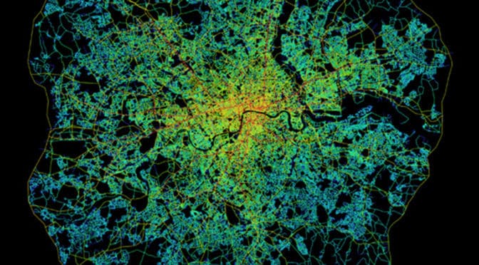
Early space syntax studies demonstrated the potential of the axial map to reveal important functional characteristics about the urban spatial network. This is because urban space tends to be linear with streets, boulevards, avenues, and alleys but with only occasional (in relative terms) convex elements such as squares and public open space (Hillier, 2005). This can been seen most clearly in axial map of Greater London within the M25 (see below). The axial map represents the most optimal line of sight passing through every accessible space in the London street network until accounting for all accessible spaces and, then, measuring and graphically representing the spatial configuration of that network in terms of topological depth (see Space Syntax for Dummies, Part 2). Penn et al (1997) define the axial map as “the minimal set of axial lines such that the set taken together fully surveys the system, and that every axial line that may connect two otherwise-unconnected lines is included” (Turner et al, 2004: 428).
Space syntax model of Greater London within the M25 (Source: Space Syntax Limited and University College London).
Topological depth (refer back to the explanation in Space Syntax for Dummies, Part 2) can be measured based on global integration (or in topological terms, betweenness) because it measures the configurational relationship of all spaces to all others across the entire spatial network. It can also be measured to provide a more localized picture of spatial configuration by measuring local integration (or in topological terms, choice). The latter can be most easily understood if you imagine yourself standing at the intersection of two streets. Simultaneously, you are in and can see along the length of these two streets but also see all other streets – as well as other urban functions, i.e. level of use by people and cars, land uses, building heights. etc. – intersecting with them from your position. Or, topological depth can be measured in terms of radii between these two extremes. The space syntax model of Greater London within the M25 (see above) does so by limiting the radius based on the mean depth from the most globally integrated street; in this case, Oxford Street. The space syntax software automatically colors the degree of integration for each axial line. The color range is from red (most integrated) through orange, yellow, and blue, light blue, blue to purple (most segregated). At this point, the space syntax model is still a purely mathematical representation of configurational pattern. The analysis did not yet take in account other urban functions such as land use, building heights or population density though, of course, this information can be inputted into the model using GIS. Despite this, the axial map appears to provide a very realistic picture of how London operates as an urban spatial network.
An early key finding of space syntax research was establishing there is a relationship between the spatial configuration of the urban grid and patterns of pedestrian and vehicular movement (Hillier et al, 1993; Penn and Hillier, 1998). Penn and Hillier (1998) found that integrated spaces carry larger movement flows than more segregated ones, and the effects were strong and consistent. The key discovery was the correlation between movement flows and a purely configurational measure of the urban spatial network before ever taking into account the location of attractors or generators of movement. This led to the formulation of the theory of natural movement. The theory of natural movement states that movement patterns in the urban environment arise naturally from the way the urban grid organizes the simplest routes to and from all locations involving the fewest changes of changes in that grid. This means it is the design of the urban pattern in the shape of its grid that most matters. In this sense, natural movement is akin to a background effect of the urban grid since most movement in space will tend to be through-movement that is passing through a space on its way to somewhere else in the urban grid. The distribution of activities and land uses then has the potential to further intensify, or detract from, the background effects of natural movement (Hillier, 1996; Hillier and Vaughan, 2007).
A fundamental concept to arise from the theory of natural movement is the city as a movement economy. Namely, it is the pattern of the spatial network as generated by the urban grid, rather than the traditional planning emphasis on origin and destination matrices, which is the fundamental thing about the functioning of cities (Hillier, 1996). The urban grid generates a probabilistic but predictable pattern to the way people move through and occupy spaces in cities. Some spaces receive more movement and use because they are shallower within the spatial network whereas others are deeper and receive less. The spatial configuration of the urban grid generates a pattern of “attraction inequalities” whereby land uses tend to locate to exploit these potentials based on the pattern of natural movement (Hillier, 2002; 154). Retail will occupy more strategic locations to capitalize on the potential for passing trade. According to Hillier (2005), “this is not… to deny attraction… it is common sense (that) people make trips because the shops are there… but (attraction) is not fundamental” (11).
This early finding has led to a considerable body of research on how people move and occupy space, and the relationship to spatial configuration (see below and compare to the space syntax model of the Tate Gallery, Millbank in Space Syntax for Dummies, Part 1).
Routes of 100 people during the first 10 minutes of their visit to the Tate Gallery, Millbank (Hillier, et. al., 1996).
This simple introduction on The Outlaw Urbanist only begins to scratch the surface of the volume of research available from the use of space syntax over the previous 30 years. However, it should provide you with a solid foundation to jump into this vast collection of research, most of which is freely available online. For example, more than 500 research papers composing the proceedings of every Space Syntax Symposia for nearly twenty years is freely available for download via the Space Syntax Network here. Also, Chapter 3 of my forthcoming Relentless Magnificence: The American Urban Grid will delve more deeply into space syntax research and issues of methodology/terminology over the last 20 years.
Additional Reading and References
For your convenience, the easiest reading below is indicated with an *asterisk.
Hillier, Bill and L. Vaughan. 2007. “The city as one thing”, Progress in Planning, 67(3): 205-230. Article available online for download from University College London here.
Hillier Bill. 2005. “The art of place and the science of space”, World Architecture, Special Issue on Space Syntax. Beijing: 11(185): 24-34 (in Chinese); 96-102 (in English). Article is currently available online for download via the Scribd here. Registration required.
*Hillier Bill. 2002. “A theory of the city as object: or, how spatial laws mediate the social construction of urban space”, Urban Design International, 7: 153–179. Article available online for download from the Nordic Urban Design Association here.
*Hillier, Bill. 1996. Space is the Machine: A Configurational Theory of Architecture. Cambridge: Cambridge University Press. Digital eBook is available for free download from University College London here.
*Hillier, Bill, M.D. Major, J. Desyllas, K. Karimi, B. Campos, T. Stonor. 1996. Tate Gallery, Millbank: A Study of the Existing Layout and New Masterplan Proposal. Technical Report, Unit For Architectural Studies, Bartlett School of Graduate Studies, University College London. Report is available for free download from University College London here.
*Hillier, Bill, A. Penn, J. Hanson, T. Grajewski, J. Xu. 1993. “Natural Movement: or, configuration and attraction in urban pedestrian movement”, Environment and Planning B: Planning and Design, 20: 29-66. Article available online for download from University College London here.
*Major, M.D. 2014. Relentless Magnificence: The American Urban Grid. Jacksonville, Florida: Forum Books, forthcoming.
Penn, Alan, B. Hillier, D. Banister, Xu, J. 1998. “Configurational modeling of urban movement networks”, Environment and Planning B: Planning and Design, 25: 59-84. Article available online for download from University College London here.
Turner, Alasdair. 2004. Depthmap 4: A Researcher’s Handbook. Bartlett School of Graduate Studies, UCL, London. Handbook available online for download from University College London here.
Space Syntax for Dummies | Part 2 BASICS by Dr. Mark David Major, AICP, CNU-A, The Outlaw Urbanist contributor
Continuing our three-part series on the basics of space syntax, Part 2 is based on excerpts from Chapter 3 of my forthcoming Relentless Magnificence: The American Urban Grid. As such, it is somewhat tailored to an American audience. The key principles discussed here are representation and configuration. What is configuration? In the simplest terms, using the most convenient definitions, configuration is not how one thing relates to another thing but how that one thing relates to all other things and also how all those other things relate to each other.
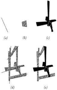
Basic representations of space syntax: (a) axial line; (b) convex space; (c) visual field or an “isovist” (after Benedikt, 1979); or used in tandem (d) axial lines passing through convex spaces; and (e) isovist from a convex space.
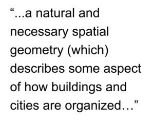
According to space syntax theory, a key to understanding urban space is a description not just of the individual elements in the city (this street or that square) but a description of the entire spatial system considered as a configurational network. Over the last three decades, spaces syntax research programs around the world have developed a series of representational and analytical techniques based on simple descriptions of space (Hillier and Hanson, 1984; Hillier, 1996; Hanson, 1998). By simple description, we mean representations that obey real physical constraints the built environment places on visibility and movement since you cannot see and move through solid objects but only through open and accessible space. First, the movement of a person or persons through the built environment tends to be linear so one representation used is the axial line or axis (see ‘a’ above). The matrix of the longest and fewest lines of sight and access that completely encompasses all the spaces of a built environment is the axial map. Second, previous research has found the occupation of space by people in the built environment will tend towards convexity, the mathematical definition of all points being visible to all others, such as a group of people gathered in a circle (Hillier et al, 1996; Campos, 1997). This simple description is a convex space (see ‘b’ above). The collection of the fattest two-dimensional lumps of space, or convex spaces, in a built environment is the convex map. Finally, the potential for seeing and moving in the built environment can also form the basis for a simple description of space, which Benedikt (1990) called the isovist or, more simply, the visual field at eye level (see ‘c’ above) (Hillier et al, 1987; Conroy Dalton et al, 2003). An isovist describes all visible and accessible space to which a person or persons might move as defined from a particular point or set of points. Later methodological developments in space syntax allow for the measurement of the configurational relationship of all visual fields from a gridded set of points (or point isovists) to all others in a built environment. These form a matrix of visual fields where some are more strategic than others for understanding the spatial network as a whole (see the space syntax model of visual fields in the Tate Gallery, Millbank in Space Syntax for Dummies, Part 1). This is a visibility graph (Turner and Penn, 1999). Finally, any combination of these representations can be used to create a more complex picture of the built environment, depending on the problem researched (see ‘d-e’ above). Hillier (2005) describes these simple descriptions as “a natural and necessary spatial geometry (which) describes some aspect of how buildings and cities are organized… as a vital aspect of how we create them, use them and understand them” (5). This is how to represent space.
However, some additional clarification is required about what is meant by configuration. Configuration is a relational system based on topological graph theory whereby any local changes in that system can have global effects across that system (Hillier, 1993; Hillier, 1996).
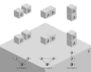
Configuration: (top) Relation between two objects so ‘a’ is to ‘b’ as ‘b’ is to ‘a’; (bottom left) A configurational relationship is created in relation to a third object, such as the surface of the Earth; (bottom center) Connection or permeability changes the configurational relationship between the three objects so all are equally shallow from the other; or, (bottom right) an asymmetrical relationship between the three objects whereby ‘b’ or ‘c’ can only be reached via ‘a.’
For example, two objects are in a mathematical relationship to each other so it can be said that ‘a’ is to ‘b’ as ‘b’ is to ‘a’ (see above, top). Once this relationship is established with reference to a third object, in this case the surface of the earth, there is a configurational relationship (see above, bottom). If the objects are distinct, then it can be said ‘a’ is to ‘c’ as ‘b’ is to ‘c’ but, in order to reach ‘a’ from ‘b’ or vice versa, one has to pass through ‘c’. This can be seen more clearly in the corresponding topological graph where ‘c’ is shallower to ‘a’ and ‘b’ than they are to each other. The depth of ‘a’ or ‘b’ to any other object in the system is three whereas the depth from ‘c’ to ‘a’ or ‘b’ is two and total depth in the system of objects is eight. Next, ‘a’ and ‘b’ can be placed next to each other to introduce the idea of permeability or connection into the system of objects. The objects are in a symmetrical relationship where all spaces are maximally shallow from each other, so that ‘a’ is to ‘b’ as ‘b’ is to ‘c.’ In this case, the depth from any object to any other is two and total depth in the system is six. Finally, if ‘b’ is placed on top of ‘a’, this forms an asymmetrical relationship with reference to ‘c.’ You have to pass through ‘a’ in order to reach ‘b’ from ‘c’ or vice versa but you are not required to pass through ‘b’ to go from ‘c’ to ‘a.’ In this case, the depth of ‘b’ and ‘c’ is three and depth from ‘a’ is only two. Total depth in this asymmetrical relationship is eight (Major, 2000). According to Hillier (2005), “space syntax seeks to formulate mathematically the configurational properties of space that we intuit, as manifested in the way… we construct real spatial patterns through building and cities” using topological graph theory to objectively measure these spatial patterns (6).
These are the basic principles underlying space syntax.
Additional Reading and References
For your convenience, the easiest reading below is indicated with an *asterisk.
Benedikt, Michael L. 1979. “To take hold of space: Isovists and Isovists Fields”, Environment and Planning B: Planning and Design, 6: 47-66. Article is currently available online for download from the Massachusetts Institute of Technology here.
Campos, Maria Beatriz de Arruda. 1997. “Strategic Space: Patterns of Use in Public Square of the City of London”, First International Space Syntax Symposium Proceedings (Eds. M.D. Major, L. Amorim, F. Dufaux), 2: 26.1-26.11. Article is currently available online for download via the Space Syntax Network here.
Conroy Dalton, Ruth and S. Bafna. 2003. “The syntactical image of the city: A reciprocal definition of spatial elements and spatial syntaxes”, Fourth International Space Syntax Symposium Proceedings, London, 2003: 59.1-59.22. Article is currently available online for download via the Space Syntax Network here.
Hanson, Julienne. 1998. Decoding Homes and Houses. Cambridge: Cambridge University Press. Available for purchase from Amazon here.
Hillier Bill. 2005. “The art of place and the science of space”, World Architecture, Special Issue on Space Syntax. Beijing: 11(185): 24-34 (in Chinese); 96-102 (in English). Article is currently available online for download from Scribd here. Registration required.
*Hillier, Bill. 1996. Space is the Machine: A Configurational Theory of Architecture. Cambridge: Cambridge University Press. Digital eBook is available for free download from University College London here.
*Hillier, Bill, M.D. Major, J. Desyllas, K. Karimi, B. Campos, T. Stonor. 1996. Tate Gallery, Millbank: A Study of the Existing Layout and New Masterplan Proposal. Technical Report, Unit For Architectural Studies, Bartlett School of Graduate Studies, University College London. Report is available for free download from University College London here.
*Hiller, Bill, J. Hanson, H. Graham. 1987. “Ideas are in things: an application of space syntax method to discovering housing genotypes”, Environment and Planning D: Planning and Design, 14: 363-385. Article is available for free download from University College London here.
Hillier, Bill and J. Hanson. 1984. The Social Logic of Space. Cambridge: Cambridge University Press. Available for purchase from Amazon here.
*Major, M.D. 2014. Relentless Magnificence: The American Urban Grid. Jacksonville, Florida: Forum Books, forthcoming.
Turner, Alasdair and A. Penn. 1999. “Making Isovists Syntactic: isovist integration analysis”, Second International Space Syntax Symposium Proceedings (Eds. F. de Holanda, L. Amorim, F. Dufaux), 1:11.01-11.14. Article is currently available online for download via the Space Syntax Network here.
Stay tuned for Space Syntax for Dummies, Part 3: Results.
Share the knowledge!
Blogging about architecture, urbanism, and culture…


 Purchase your copy of Poor Richard, Another Almanac for Architects and Planners (Volume 2) today!
 This is because urban space tends to be linear with streets, boulevards, avenues, and alleys but with only occasional (in relative terms) convex elements such as squares and public open space (Hillier, 2005). This can been seen most clearly in axial map of Greater London within the M25 (see below). The axial map represents the most optimal line of sight passing through every accessible space in the London street network until accounting for all accessible spaces and, then, measuring and graphically representing the spatial configuration of that network in terms of topological depth (see
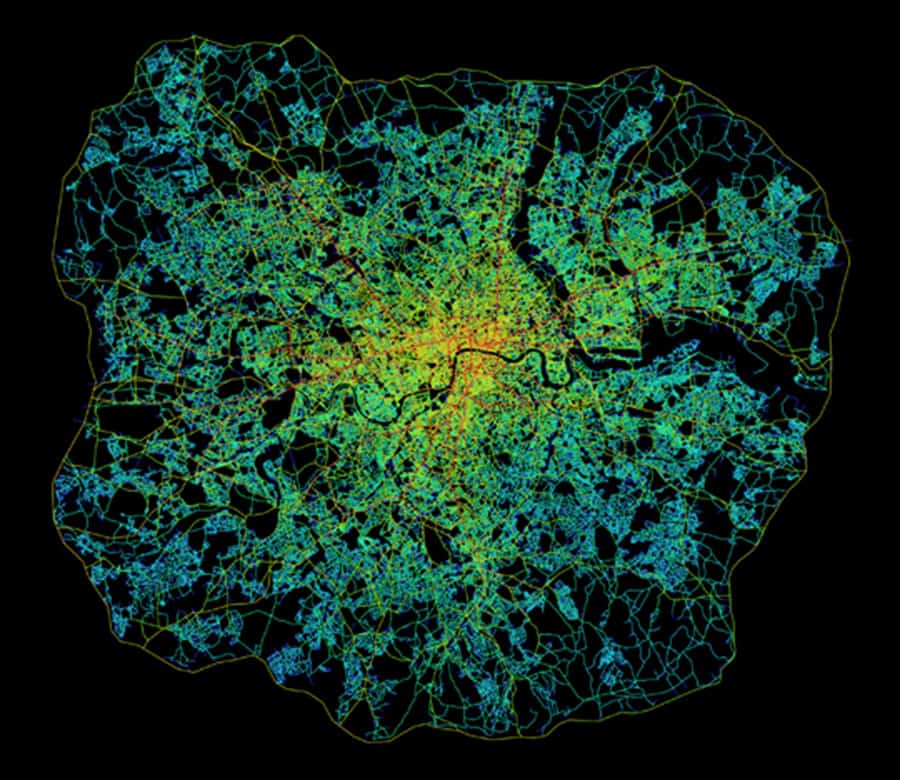
 This means it is the design of the urban pattern in the shape of its grid that most matters. In this sense, natural movement is akin to a background effect of the urban grid since most movement in space will tend to be through-movement that is passing through a space on its way to somewhere else in the urban grid. The distribution of activities and land uses then has the potential to further intensify, or detract from, the background effects of natural movement (Hillier, 1996; Hillier and Vaughan, 2007).
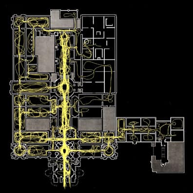
 Later methodological developments in space syntax allow for the measurement of the configurational relationship of all visual fields from a gridded set of points (or point isovists) to all others in a built environment. These form a matrix of visual fields where some are more strategic than others for understanding the spatial network as a whole (see the space syntax model of visual fields in the Tate Gallery, Millbank in