Quantifying the Cost of Sprawl: In infrastructure, service delivery and tax receipts by Emily Badger, CityLab, May 21, 2013
Excerpt:
Sprawl is expensive. It costs more money to pave a road and connect a sewer line to five families each living a block apart on wooded lots than to build public infrastructure for those same five families living in a condo. It costs more money (and takes more time and gas) to serve those families with garbage trucks, fire engines, and ambulances. And in return… those five sprawling single-family homes likely yield less in tax revenue per acre than the apartment building that could house our fictitious residents downtown.
A report… from Smart Growth America, which surveyed 17 studies of compact and sprawling development scenarios across the country, sizes up the scale of the impact this way: Compact development costs, on average, 38 percent less in up-front infrastructure than “conventional suburban development” for things like roads, sewers and water lines. It costs 10 percent less in ongoing service delivery by reducing the distances law enforcement or garbage trucks must travel to serve residents (well-connected street grids cut down on this travel time, too). And compact development produces on average about 10 times more tax revenue per acre.
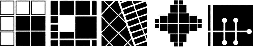
Form and process in the urban pattern: (left to right) grid expansion, block size manipulation, deformation, street extension, and discrete separation.
The City’s Essential DNA
by Mark David Major, AICP, BA, BA, MSc
Founder, The Outlaw Urbanist
NOTE: This is a shorter, punchier, reference-free version of “The City’s Essential DNA: Formal design and spatial processes in the urban patterns”, which appears in Volume 4, Issue 1 of The Journal of Space Syntax, 2013, pp 160-164, ISSN: 2044-7507. It was prepared at the request of a Planning Department for their academic publication but they decided to pass on the article because it was “too technical”.
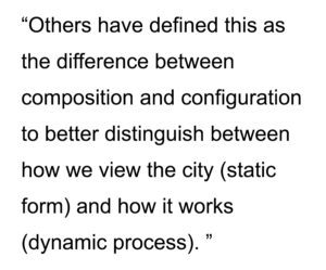
Our descriptions of cities are often based on their physical form. In urban theory, the description of ‘organic’ and ‘regular’ cities is one of the most persistent and useful. The first stresses process over time in terms of unplanned growth whereas the second on conscious design. This ‘shorthand’ provides a basic understanding of cities across different times, cultures, and geographical regions, which is useful precisely because they are theory-loaded terms. They seemingly convey a lot of information in an easy-to-grasp manner. Regular explicitly describes physical form and the design process that gave rise to it. Organic explicitly describes process over time in terms of urban growth, tacitly understood such cities tend to be characterized by deformed grids. The explicit and implicit description of urban form and process is the basis of their descriptive value since most cities are easily classified as having common or different attributes when characterized as organic or regular. There have been frequent attempts to develop better terminology. Utilitarian, deformed, surface order, neutral, offset, gridiron, radial, uniform, homogeneous, undifferentiated matrix, sprawl, geomorphic… the amount of jargon is enough to give anyone a headache. However, describing urban form as deformed or regular is also theory-loaded since cities are characterized in geometrical terms. The key is the incidence or deficiency of a readily apparent geometry in the physical composition of streets and blocks in plan. American cities tend to possess such geometries so they are regular grids. European or Middle Eastern ‘organic’ cities appear to lack such geometries so they are deformed grids. Others have defined this as the difference between composition and configuration to better distinguish between how we view the city (static form) and how it works (dynamic process). Composition is an easy-to-grasp, understand-all-at-once description and configuration is a more complex view of relations amongst elements that potentially affect urban functions. This distinction is often confused or misunderstood, inevitably leading us to a theoretical dead-end.
At a detailed scale, the Urban Transect specifies this distinction between form and process in the design of the street itself for those transitioning from Euclidean zoning to form-based codes. Several formal elements (street width, road sections, building footprints, landscaping) are tied to functional uses (density and intensity). If cities are interfaces between scales of movement, as suggested by John Peponis at Georgia Tech, then the Urban Transect creates an idealized model of this essential urban dynamic of form and process for the design of streets to better classify it for application in form-based zoning regulations and streetscape design. Duany and Talen’s explanatory diagram of transect planning specifies a geometric logic (all urban streets connect at right angles) but the applicability of transect planning for types of cities seems readily apparent. What varies from one city to another is geometry and scale as realized in the layout. The true brilliance of transect planning is, the more it is applied in real world conditions, then the less tenable becomes the roadway classifications of modern transportation planning. Those beholden to the dominant 20th century planning paradigm should beware of New Urbanists bearing gifts.
Andres Duany and Emily Talen’s The Urban Transect
Transect planning is largely silent about generating an urban pattern above the level of the street, leaving this to the design sensibilities of the professionals. This appears to leave a gulf of understanding between the urban whole and the street itself. However, this is precisely where the essential dynamics of form and process as it impacts on urban functions are realized in cities. Hiller and Hanson argue in The Social Logic of Space the physical arrangement of space “has a direct relation – rather than a merely symbolic one – to social life, since it provides the material preconditions for patterns of movement, encounter and avoidance which are the material realization – sometimes the generator – of social relations.” New Urbanists have been basically arguing the same for thirty years. In everyday practice, this becomes complicated because we tend to view and design space in discrete terms, independent of a larger geographical, topographical, and/or urban context. In doing so, the importance of design in establishing the material preconditions for our everyday use of urban space is often minimized, misunderstood, or even ignored.
Our design decisions in generating the urban pattern are important. For example, it is in this realm that an important (and little discussed) distinction arises between intra-connectivity (street connections within the bounds of a site) and inter-connectivity (street connections between bounds of different sites). Historically, intra-connectivity has been strongly realized in New Urbanism developments but inter-connectivity weakly so. We cannot simply leave design of the urban pattern to the (varied) abilities of professionals and hope for the best. We must identify and understand it so we can intervene better and smarter. If we focus on the static and dynamic relationship between form and process, composition and configuration, in the design of the urban grid, a basic set of design decisions having formal and process implications for urban space can be identified.
We could describe this as the essential DNA for all types of cities. There is grid expansion and deformation, whereby the urban pattern expands in a consistent manner or else deforms in relation to some external factor, usually topography or land ownership patterns. In regular cities, deformation usually occurs whilst still adhering in some manner to the basic conceptual order of the existing urban pattern but in different cardinal directions. In organic cities, deformation tends to occur during up-scaling of the urban pattern to relation to its ever-growing edges by introducing more geometrical order in the layout. There is street extension, whereby an existing street is extended in one of both directions. In regular cities, this tends to occur as a straight-on continuation in adherence to the conceptual order of the regular grid. In organic cities, this tends to occur as an open-angled continuation, which generates its distinctive deformed grid pattern. Street extension is also the primary tool for strip development in the growth of linear and crossroad settlements, especially during the early stages of community growth, of which Las Vegas is probably the most famous example. The most easily recognizable form of the essential urban dynamic is block size manipulation.
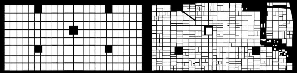
Philadelphia, Yesterday and Today: Philadelphia urban pattern in 1682 (left) and today (right) within bounds of William Penn’s original 1682 plan.
The dynamic nature of block size manipulation in our cities can be easily seen in a side-by-side figure ground representation (blocks in white, space in black) of Philadelphia yesterday and today. There are two remarkable yet seemingly contradictory things about this comparison. First, is the degree to which the original block scheme of Penn’s plan has changed, principally through a process of block subdivision and, second, is the degree to which the integrity of Penn’s original plan concept has endured despite hundreds, perhaps thousands, of small- and large-scale interventions over 330 years. Finally, there is discrete separation by linear segregation of streets. Street connections are either broken (as in American suburban sprawl through interruptus in extremis) or complicated (as in Middle Eastern cities by narrowing street widths to generate labyrinthine-like but still well-connected layouts) to isolate (usually residential) areas in the urban pattern.
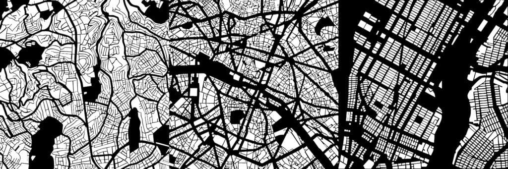
These design methods can be found in the urban pattern of all cities. The spatial processes associated with formal design tend to converge on the ortho-radial grid model. This is a prime example of what Carvalho and Penn mean, saying “the impact of local controls on growth… is, at most, spatially localized… at a macro level, cities display a surprising degree of universality.” In fact, the essential variation across different types of cities appears the scale of street lengths and connections tied to their degree of geometrical articulation; longer, more connected and expansive in regular cities primarily using right angles whereas shorter, less connected, and more compact in organic cities using open and right angles. In the end, cities are not so complicated; rather, it is our theories that tend to complicate our understanding of them.
The Urban Pattern: Istanbul, Turkey (left), Paris, France (center), and New York in the United States (right) (Note: not to scale)
Based on excerpts from forthcoming The Syntax of City Space: American Urban Grids by Mark David Major.
“Sent to spy on a Cuban talent show, First stop- Havana au go-go, I used to make a living, man, Pickin’ the banana, Hooray for Havana!” — Havana Affair, The Ramones
Urban Patterns | Havana, Cuba by Dr. Mark David Major, AICP, CNU-A
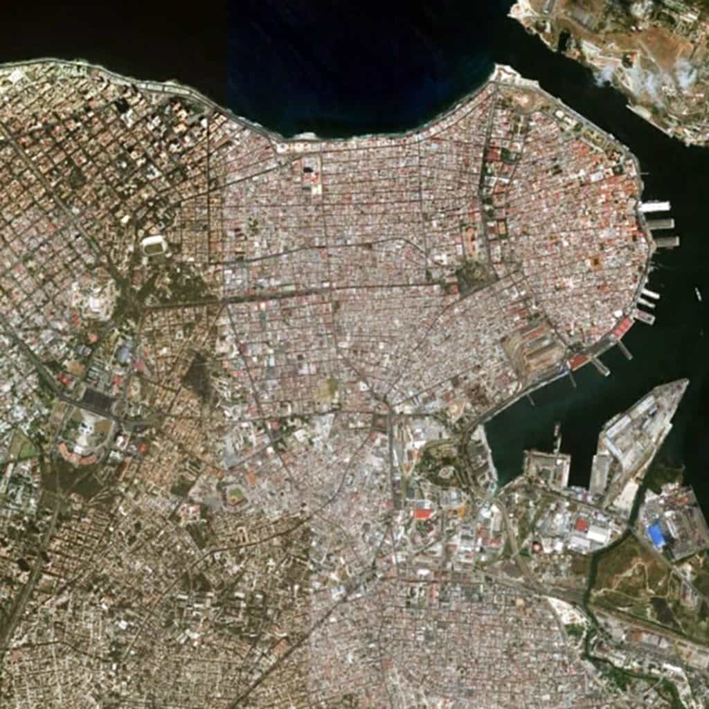
Havana is the capital city, major port, and leading commercial center of Cuba. The city proper has a population of 2.1 million inhabitants and it spans a total of 728 square kilometers (281 square miles), making it the largest city by area, most populous city, and third largest metropolitan area in the Caribbean region. Havana lies on the northern coast of Cuba, south of the Florida Keys, where the Gulf of Mexico joins the Caribbean. The city extends mostly westward and southward from the bay, which is entered through a narrow inlet and divides into three main harbors: Marimelena, Guanabacoa, and Atarés. Havana was founded by the Spanish in the 16th century and, due to its strategic location, served as a springboard for the Spanish conquest of South America, becoming a stopping point for treasure-laden Spanish Galleons on the crossing between the New World and Old World. King Philip II of Spain granted Havana the title of City in 1592. Walls and forts were built to protect the old city. Contemporary Havana can essentially be described as three cities in one: Old Havana, Vedado, and the newer suburban districts. Old Havana, with its narrow streets and overhanging balconies, is the traditional center of Havana’s commerce, industry, and entertainment as well as being a residential area. To the north and west a newer section – centered on the uptown area known as Vedado – has become the rival of Old Havana for commercial activity and nightlife. Centro Habana, sometimes described as part of Vedado, is mainly a shopping district that lies between Vedado and Old Havana. Chinatown and the Real Fabrica de Tabacos Partagás, one of Cuba’s oldest cigar factories, is located in the area. A third Havana is that of the more affluent residential and industrial districts that spread out mostly to the west. Among these is Marianao, one of the newer parts of the city, dating mainly from the 1920s (Source: Wikipedia).
The urban pattern of Havana, Cuba can be best described as a patchwork of regular and regular-like grids that vary in scale in terms of the length and width of streets and block sizes. Most streets in Havana can be fairly described as straight. Their lengths tend to vary based on the local grid pattern and whether any particular street is carried through and embedded within another adjacent grid or terminates at the edges of its own grid. In this sense, the urban pattern of Havana appears remarkably similar to that of Athens, Greece, which is also composed of a patchwork of small-scale (mostly) regular grids. There appears to be the pattern of scale in the urban grid related to the age of a local area, forming a somewhat radial pattern from the harbor to the southerly and (more so) westerly direction. For example, Old Havana has the smallest scale regular-like grid in the city (smaller blocks, shorter streets) though the overall geometric order of the urban grid in this area is less consistent than in younger areas of the city. For example, contrast this with the increase in scale of the regular grid in the Vedado area to the west of Old Havana or the generous scale of block sizes, street lengths and widths in the highly geometrical grid of Marianao area along a different cardinal alignment in relation to the shoreline of the coast to the extreme west (partially visible at the left edge of the above satellite image).
(Updated: July 12, 2017)
Urban Patterns is a series of posts from The Outlaw Urbanist presenting interesting examples of terrestrial patterns shaped by human intervention in the urban landscape over time.
“Look around, leaves are brown And the sky is a hazy shade of winter.” — Hazy Shade of Winter, Simon & Garfunkel
Admit it: most of us prefer the 1987 version by The Bangles.
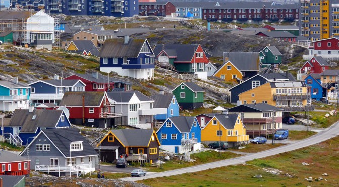
Urban Patterns | Nuuk, Greenland by Dr. Mark David Major, AICP, CNU-A
NOTE: Urban Patterns is focusing on more obscure and/or extreme locations in a number of posts over the next few weeks.
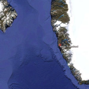
Satellite view of Nuuk on the southwest coast of Greenland from 800 km (Image: US Geological Survey, Landsat and IBCAO, Data SIO, NOAA, U.S. Navy, NGA, GEBCO, courtesy of Google Earth, 2013). The north coast of Baffin Island, Canada is to the extreme left of this image.
Nuuk, Greenland is the capital city of Greenland. It is located at the end of the Nuup Kangerlua fjord on the eastern shore of the Labrador Sea. The area around Nuuk has a long history of habitation dating as far back to 2,200 BC including the ancient pre-Inuit, Vikings/Norse, Norwegian, and Danish people. The colony founded in 1728 by the Dano-Norwegian Crown consisted of mutinous soldiers, convicts, and prostitutes; most of whom died within the first year of scurvy and other ailments. Today, it has a population of approximately 16,500 people and over a third of Greenland’s total population lives in the Nuuk Greater Metropolitan area. The town has steadily grown over the last two decades with the population increasing by over a third relative to the 1990 levels, and by over 22% relative to the 2000 levels. Nuuk has developed trade, business, shipping, and other industries. It began as a small fishing settlement with a harbor but, as the economy developed rapidly during the 1970s and 1980s, the fishing industry declined. However, seafood including fish, seal, and so forth is still sold in abundance in Nuuk and the capital contains a number of fish markets. Minerals such as zinc, gold, and so forth have significantly contributed to the development of Nuuk’s economy. The city, like much of Greenland, is heavily dependent upon Danish funding and investment (Source: Wikipedia).
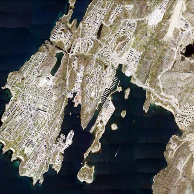
Satellite view from 10km of Nuuk, Greenland in 2013 (Source: Google Earth).
The urban grid of Nuuk is somewhat unexpected. Given the extreme polar climate, one might expect a more compact layout to promote energy and heat efficiency in the settlement. However, the town has more of a dispersed deformed grid layout, perhaps somewhat more characteristic of Inuit settlements in the horizontal dimension whilst much of the architecture reflects a Danish/European influence in the vertical dimension (see the header image). The dispersed nature of the urban grid might also be reflective of the rapid growth occurring in the town over the previous three decades. Some areas of the urban grid are laid out in a manner consistent with American suburban sprawl patterns, especially to the east and north of the town. The somewhat hilly terrain of the town probably plays a role in this settlement form as well. Given its location in Greenland, several things about Nuuk might, at first glance, strike some people as odd: for example, Nuuk has its own golf club and course, which is adjacent to the University of Greenland campus (yes, there is a university but only 150 students); there is the Greenland National Museum, a National Library, and a Greenland National Bank; and, even two stadia located in the town, a futbol stadium with a seating capacity of 2,000 people and a handball stadium that can hold 1,000 people. Nuuk, Greenland is so unexpected in many ways, which it is utterly fascinating.
(Updated: July 4, 2017)
Urban Patterns is a series of posts from The Outlaw Urbanist presenting interesting examples of terrestrial patterns shaped by human intervention in the urban landscape over time.
“Thoughts meander like a restless wind, Inside a letter box, They stumble blindly, as they make their way,Across the universe.” — Across the Universe, The Beatles
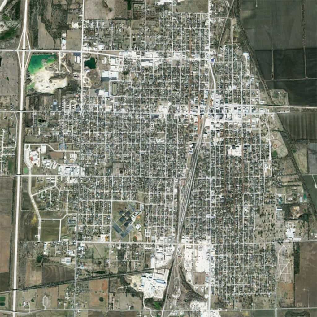
Urban Patterns | The Center of Our Terrestrial Universe | Chanute, Kansas USA by Dr. Mark David Major, AICP, CNU-A
NOTE: Urban Patterns will focus on more obscure and/or extreme locations in a number of posts over the next few weeks.
According to the Mac version of Google Earth, the center of our terrestrial universe can be found in the City of Chanute of Neosho County, Kansas. When you open Google Earth on a Mac, allow the globe to stop spinning, then only zoom in on the Earth and you’ll eventually find yourself in Chanute, Kansas. Dan Webb, a software engineer for the Mac OS X version of Google Earth, programed the software this way; he explains his charmingly flippant reasons here. Incidentally, if you do the same on the Windows version of Google Earth (you know, fifteen minutes after the PC has started up and Windows has downloaded all of its updates), you’ll actually end up in Lawrence, Kansas. However, since Apple is infinitely superior to Windows, then the Mac version of Google Earth must be correct about our ‘terrestrial center’.
Satellite view from 5 km of Chanute, Kansas USA (Source: Google Earth).
“Neosho” is a Native American word generally accepted to be of Osage derivation. It is translated variously as “water that has been made muddy”, “clear cold water” or “clear water”, the last being the most accepted. Chanute was formally founded in 1873. When the Leavenworth, Lawrence & Galveston Rail Road crossed the Missouri, Kansas and Texas state limits within Neosho County, four rival towns initially sprang up in the vicinity of the junction: New Chicago, Chicago Junction, Alliance, and Tioga. The four towns were consolidated in 1872 and the new town was named Chanute in honor of Octave Chanute, a railroad civil engineer. Chanute has a population of approximately 9,100 people (Source: Wikipedia). The urban pattern of Chanute is characterized by several typical – but still interesting – components of the American landscape. First, there is a predominant regular grid aligned to the cardinal directions, consistent with the method of land division established by the 1785 Land Ordinance in the United States; Second, this regular grid marginally shifts from perfect orthogonality. For example, West Main Street (the primary east-west route toward the top of the above image) marginally shifts northward along some distance before shifting southward again into alignment with East Main Street on the other side of the railroad tracks. Third, this regular grid has evolved over time around the railroad line passing through the center of Chanute in a southwest to northeast direction (from Tulsa, Oklahoma to Kansas City, Missouri). This generates a significant interruption to the orthogonal grid in the town, introducing differentiation from east-to-west by privileging those routes crossing the tracks to link both sides of town. Indeed, the interruptions (e.g. the railroad tracks, the large block to the south defining the Neosho Community College campus, and 215th Road/E. Elm Street angling into the regular grid from the east at the upper middle right of the above image) to the regular grid of Chanute characterize the town as much as the regular grid itself. Finally, the western edge of Chanute is defined by State Highway 169, which mirrors the Tulsa-to-Kansas City alignment of the railroad. However, this is not an interstate highway. Chanute is almost exactly at the center of a ring of interstates, more than a hundred miles in any direction to 35/335 to the north and west, 498 to the east, and 44 to the south. Because of this, and the fact that its population has remained relatively stable over the last 100 years (only variation of +/- 1,000), Chanute has maintained its small-town persona as an American farming community.
(Updated: July 3, 2017)
Urban Patterns is a series of posts from The Outlaw Urbanist presenting interesting examples of terrestrial patterns shaped by human intervention in the urban landscape over time.
Share the knowledge!
Blogging about architecture, urbanism, and culture…

 The key is the incidence or deficiency of a readily apparent geometry in the physical composition of streets and blocks in plan. American cities tend to possess such geometries so they are regular grids. European or Middle Eastern ‘organic’ cities appear to lack such geometries so they are deformed grids. Others have defined this as the difference between composition and configuration to better distinguish between how we view the city (static form) and how it works (dynamic process). Composition is an easy-to-grasp, understand-all-at-once description and configuration is a more complex view of relations amongst elements that potentially affect urban functions. This distinction is often confused or misunderstood, inevitably leading us to a theoretical dead-end.
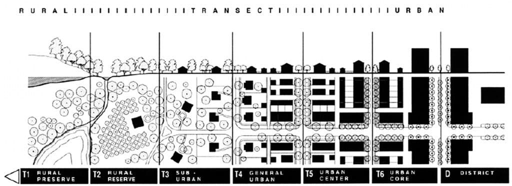
 If we focus on the static and dynamic relationship between form and process, composition and configuration, in the design of the urban grid, a basic set of design decisions having formal and process implications for urban space can be identified.