Tag Archives: Urban Pattern

Urban Patterns | St Louis, Missouri USA

“I will be your tootsie wootsie,
If you will meet in St. Louis, Louis,
Meet me at the fair.”
— Meet Me in St. Louis, Judy Garland

Urban Patterns | St. Louis, Missouri USA
by Dr. Mark David Major, AICP, CNU-A

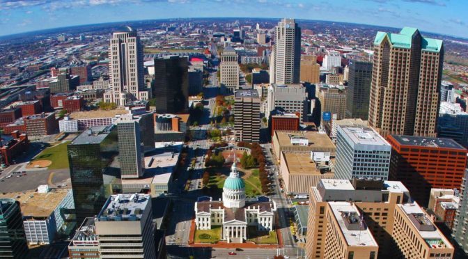
St. Louis is an independent city (meaning it is not part of St. Louis County) and major American port in the state of Missouri, built along the western bank of the Mississippi River, on the border with Illinois. The city had an estimated population of 311,404 in 2016. It is the cultural and economic center of the Greater St. Louis area (metropolitan population of 2.9 million people), making it the largest metropolitan area in Missouri and the 19th-largest in the United States (Source: Wikipedia).

map, St. Louis, 1780, archives, Wikipedia
A map of St. Louis in 1780. From the archives in Seville, Spain (Source: Wikipedia).

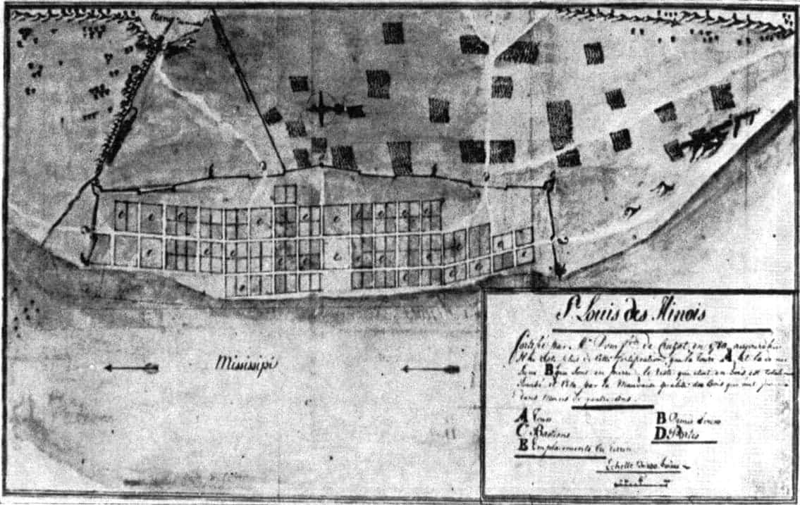
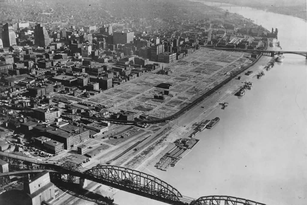
Prior to European settlement, the area was a major regional center of Native American Mississippian culture. The city of St. Louis was founded in 1764 by French fur traders Pierre Laclède and Auguste Chouteau, and named after Louis IX of France. In 1764, following France’s defeat in the Seven Years’ War, the area was ceded to Spain and retroceded back to France in 1800. Nominally, the city operated as an independent city after 1764 until 1803, when the United States acquired the territory as part of the Louisiana Purchase. During the 19th century, St. Louis developed as a major port on the Mississippi River. In the 1870 Census, St. Louis was ranked as the 4th-largest city in the United States. It separated from St. Louis County in 1877, becoming an independent city and thus, limiting its own political boundaries. In 1904, it hosted the World’s Fair/Louisiana Purchase Exposition and the Summer Olympics (Source: Wikipedia).

Satellite view, 15 km, St. Louis, Missouri, USA, Google Earth
Satellite view from 15 km of St. Louis, Missouri in the USA (Source: Google Earth).

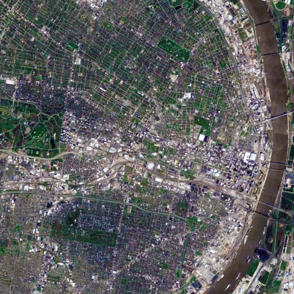
The St. Louis urban pattern is composed of a series of small-scale regular grids of varying size, which are offset in relation to each other. This originally occurred due to adapting the regular grid layout to the topography of the Mississippi River adjacent to the riverfront at this location to ensure that most valuable lots were rectangular in shape for the purposes of buildability. Like other cities in the world composed of offset, regular grids (such as Athens, Greece and New Orleans, Louisiana), this – in combination with the distribution of land from afar by the French/Spanish crowns during the Colonial period – had a ‘cascade effect’ in shaping the layout and orientation of future parcels of small-scale regular grids in the city. Later, railroad lines running east-west introduced a very strong north-south divide in the city, which persists to this day. Oddly, this divide (historically reflecting a post-war racial divide in the city, e.g. whites in south St. Louis and blacks in north St. Louis) has been reinforced by Federal, state, and city planning efforts such as the Jefferson National Expansion Memorial (i.e. Gateway Arch) grounds on the riverfront in downtown St. Louis.

St Louis, Warehouse District, New Orleans, French Quarter, 1930s, Gateway Arch
St. Louis’ Warehouse District – same size as two New Orleans’ French Quarters – demolished during the 1930s to (eventually) make way for the Jefferson National Expansion Memorial grounds and Gateway Arch though this riverfront land remained vacant for over two decades.

Urban Patterns is a series of posts from The Outlaw Urbanist presenting interesting examples of terrestrial patterns shaped by human intervention in the urban landscape over time.

Share the knowledge!
Share

PHOTO ESSAY | Havana, Cuba | Part 2

PHOTO ESSAY | Havana, Cuba | Part 2
Photographs by Concrete Blonde

Part 2 of a brief photographic essay of architecture and urban space in Havana, Cuba courtesy of Concrete Blonde. Again, the urban vocabulary of Havana is remarkably consistent: the street life of urban balconies, the use of balcony gardens in softening the urban streetscape, rooftop terraces, abundant use of urban sidewalk arcades, and the use of color.

Looking over a Havana neighborhood through an open window with the harbor in the distance.
Havana street life above and below, courtesy of a ground-level retail shop and second floor balconies.
A narrow shopping street in Havana, Cuba.
A lavishly-vegetated garden in the courtyard of a public building in Havana, Cuba.
Vegetation hanging from a second floor balcony soften the hard edges of the urban streetscape in Havana, Cuba.
Upper-level balconies introduce additional street constitution and casual surveillance of the street in the urban environment of Havana, Cuba.
Balconies and sidewalk arcades defining the street vocabulary of Havana, Cuba.
A street space well-used by pedestrians in Havana, Cuba.
A narrow street width in Havana, Cuba.
Finally, a light well made of empty bottles at a local restaurant in Havana, Cuba; included here only because it’s so ingeniously cool.
Share the knowledge!
Share

PHOTO ESSAY | Havana, Cuba | Part 1

PHOTO ESSAY | Havana, Cuba | Part 1
Photographs by Concrete Blonde

Part 1 of a brief photographic essay of architecture and urban space in Havana, Cuba courtesy of Concrete Blonde. In terms of urbanism, the most interesting aspects of these photographs are: the street life of urban balconies, the use of balcony gardens in softening the urban streetscape, rooftop terraces, abundant use of urban sidewalk arcades, and the use of color. In terms of political ideology, it seems symbolic that many of the cars (most likely of origin in Eastern Europe) and best architecture (at least, in terms of design if not actual age) predates the Communist Revolution lead by Fidel Castro in 1959; make of that what you will. However, the result is an urban treasure trove awaiting re-discovery and historic rehabilitation.

Havana streetscape showing sidewalk arcades and second-level balconies.
Rooftop terraces in Havana, Cuba.
Heavily-vegetated balconies in Havana, Cuba.
From this perspective, notice how the line of sight sneaks pass the corner of buildings to continue along the space of the street. Architects and planners ignore such nuances of the urban pattern at their peril.
Fantastic mural incorporated into the design of an otherwise mundane Modern building.
Contemporary pedestrian plaza, probably a conversion of an old tram/rail line running down the middle of the street. Though beautifully done, notice how empty the plaza appears during the middle of the day due to the generous street width, especially in comparison to the following photo of a heavily-populated street in Havana with a narrower street width.
A typical street scene in Havana, Cuba.
Churchyard plaza in Havana, Cuba.
Urban balconies defining the facade of an early twentieth century (1930s?) building in Havana, Cuba.
Sidewalk arcades, balconies, and rooftop terraces on another street in Havana, Cuba.

Stay tuned for Part 2 of the Havana, Cuba Photographic Essay coming soon on The Outlaw Urbanist!

Share the knowledge!
Share