A Compressed City of Time in Light | The City in Art

Wassily Kandinsky’s Moscow I (1916), oil on canvas, 49.5 x 51.5 cm, The State Tretyakov Gallery, Moscow, Russia.

A Compressed City of Time in Light | The City in Art
by Dr. Mark David Major, AICP, CNU-A

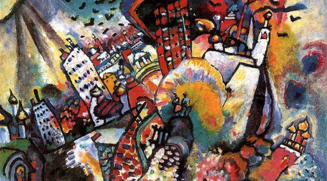
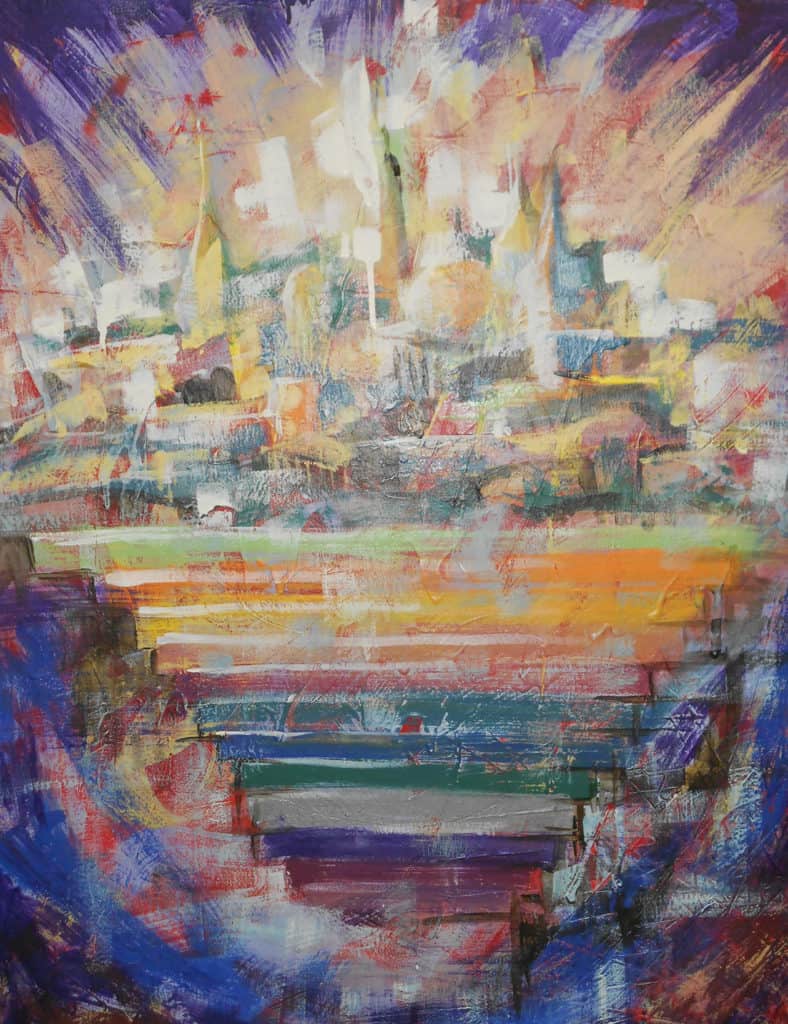
Wassily Kandinsky painted Moscow I in 1916 after he was forced to return to Russia in 1914 because of Germany’s declaration of war against Russia during World War I. The year 1915 was a period of profound depression and self-doubt during which he tried to build a new life at age 50 after living almost two decades in Munich, Germany. He did not paint a single picture. In 1916, Kandinsky painted Moscow I. He wrote, “I would love to paint a large landscape of Moscow taking elements from everywhere and combining them into a single picture weak and strong parts, mixing everything together in the same way as the world is mixed of different elements. It must be like an orchestra” (Becks-Malorny, Wassily Kandinsky, 1866–1944, 115). Moscow I contains some of the same romantic fairy-tale qualities of his earlier paintings, fused with dramatic forms and colors. “The sun dissolves the whole of Moscow into a single spot, which, like a wild tuba, sets all one’s soul vibrating” (Kandinsky, “Reminiscences,” 360).

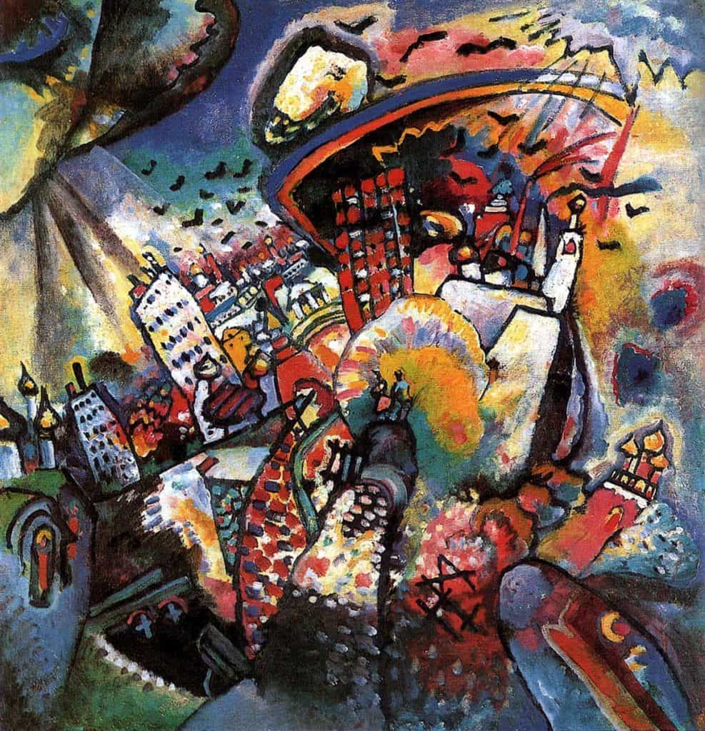
At first glance, Kandinsky’s Moscow I appears to be a simple collage of landmarks, freed of the constraints of gravity and space, represented in a highly abstract manner by the artist. However, upon closer examination, there appears to be a logic to the almost spherical layout of objects composing the Moscow built environment (for example, the Kremlin is clearly represented towards the lower right). Using Kandisky’s own words about this painting as a guide (see above), we can hypothesize Kandisky placed these objects within the frame of the painting in relation to the time of day when each achieves its apex in terms of natural light and vibrant color, hence the almost spherical layout and luxurious richness of the hues. The spherical layout seems to mirror the path of the sun across the sky, or perhaps the daylight hours on the face of a clock. In this sense, Kandinsky’s Moscow I is a notional ‘clock of the city’, representing for us the optimal passage of time to see the collected objects of the city as shown in the painting. If true, then it is a clever means to elevate the painting beyond mere collage, above the mere randomness of collected objects that are compressed and freed of space. It also embeds his representation of Moscow with a kinetic energy that metaphorically accounts for the activity of urban life itself, the city as more than a mere collection of things but as a thing that, in itself, is alive.

About Wassily Kandinsky
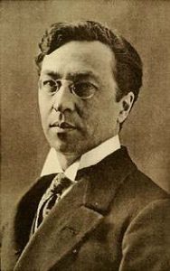
Wassily Kandinsky (born December 16, 1866, died December 13, 1944) was a Russian painter and art theorist. He is credited with painting the first purely abstract works. With the possible exception of Marc Chagall (who was born/educated in Russia but adopted France as his home in adulthood to the point of being considered a “Russian-French” artist), Kandinsky is probably the most influential Russian artist in human history. Born in Moscow, Kandinsky spent his childhood in Odessa but later enrolled at the University of Moscow to study law and economics. Successful in his profession, he was offered a professorship (Chair of Roman Law) at the University of Dorpat where he began painting studies (life-drawing, sketching, and anatomy) at the age of 30. In 1896 Kandinsky settled in Munich, studying first at Anton Ažbe’s private school and then at the Academy of Fine Arts. He returned to Moscow in 1914 after the outbreak of World War I. Kandinsky was unsympathetic to the official theories on art in Communist Moscow and returned to Germany in 1921. There, he taught at the Bauhaus school of art and architecture from 1922 until the Nazis closed it in 1933. Like Chagall, he then moved to France where he lived for the rest of his life, becoming a French citizen in 1939, and producing some of his most prominent pieces of art. He died at Neuilly-sur-Seine in 1944. Unlike Chagall, Kandinsky never attained the status of being (in part) a French artist but has always been considered a definitive Russian one (Source: Wikipedia).

The City in Art is a series by The Outlaw Urbanist. The purpose is to present and discuss artistic depictions of the city that can help us, as professionals, learn to better see the city in ways that are invisible to others. Before the 20th century, most artistic representations of the city broadly fell into, more or less, three categories: literalism, pastoral romanticism, and impressionism, or some variation thereof. Generally, these artistic representations of the city lack a certain amount of substantive interest for the modern world. The City in Art series places particular emphasis on art and photography from the dawn of the 20th century to the present day.

Share the knowledge!
Share

The Biblical City | Part 3

The New Jerusalem by Mollie Walker Freeman (2013).

The Biblical City: Redux
By Dr. Mark David Major, AICP, CNU-A The Outlaw Urbanist contributor

Can the Holy Bible tell us anything about urbanism?

It might seem unusual to investigate the Holy Bible for information about urbanism but the idea is not completely off-the-wall. In fact, it’s the subject of a fascinating 1997 study, The City in the Bible: A Relational Perspective, by the Jubilee Center in Cambridge, England and commissioned by the Anglican Church of England (Crook, 1997). The Jubilee Centre is a non-profit Christian social reform organization that “offers a biblical perspective on issues and trends of relevance to the general public” (Source: Jubilee Centre). Other writers have also examined biblical descriptions of city planning, such as those found in the Old Testament books of Leviticus and Ezekiel (Gallion and Eisner, 1963; Frick, 1997; Reps, 1979; Hawkins, 1986). However, the most comprehensive research appears to principally derive from a social science or religious studies perspective instead of architecture or urban planning. In part, this is understandable since it’s almost impossible to separate religious doctrine from any investigation of the Holy Bible, whatever the subject. The expressed purpose of the Jubilee Centre study is to explore “God’s view of today’s city (and) how modern Christians should address urban problems” with particular emphasis on the “local action” of Christians in “political and community involvement” (Crook, 1997; 5-6).

Crook (1997) correctly points out the commonly accepted, anti-urban stereotype of the Holy Bible – and presumably of God, which reached its apex beginning in the 19th century with social reformers such as Ebenezer Howard, persisting to this day – derives from popular culture perception of its most famous stories; the Garden of Eden, the construction of the Tower of Babel as a rebellion against God, God’s wrath against Sodom and Gomorrah, Jewish revolts against Rome, and Jesus’ entry/subsequent crucifixion in Jerusalem. It is an incomplete picture but even Crook is somewhat guilty of playing to this anti-urban stereotype in his 1997 study, arguing cities began and continue “in sin and rebellion… violence… corruption and oppression” (7). This statement can be equally applied to humanity in general, and not necessarily only cities in particular. However, the overwhelming majority of references to the city in the Holy Bible are neutral (see The Biblical City, Part 2), and the two most important in the New Testament are positive. As Crook (1997) concedes, “cities… represent a microcosm of God’s redemptive plan. The Bible begins in a perfect garden, but ends in a redeemed city, the New Jerusalem” (6). Jesus first introduces this microcosm of God’s plan using the city as a metaphor during the Sermon on the Mount, saying, “You are light for the world. A city built on a hill-top cannot be hidden” (NJB Matthew 5:14). In 1630, this was the source for Puritan John Winthrop’s sermon, “A Model of Christian Charity”, promoting a “city on a hill” that would become Boston. During the 20th century, John F. Kennedy and Ronald Reagan expanded on this reference in expressing an ideal of American exceptionalism as “a shining city on a hill” and a model for the entire world. In all three cases, the city is presented as an ideal to achieve (be it God’s salvation, Christian charity, or American exceptionalism) and not merely a hotbed for sin, violence, and corruption. One is forced to wonder how our planning of contemporary cities might be improved if we started from the premise that the city is a Divine ideal to achieve instead of an Earthly problem to solve.

References                  
Crook, A. 1997. The City in the Bible: A Relational Perspective. Cambridge, England: Jubilee Centre. Report commission by the Anglican Church of England.

Frick, F. 1977. The City in Ancient Israel. Princeton: SBL Dissertation Series 36.

Gallion, A.B. and S. Eisner. 1963. The Urban Pattern: City Planning and Design, Second Edition. Princeton: D. Van Nostrand Company, Inc.

Hawkins, P. 1986. Civitas: Religious Interpretations of the City. Atlanta, Georgia: Scholars Press Studies in the Humanities.

Reps, John W. 1979. Cities of the American West: A History of Frontier Urban Planning. Princeton, NJ: Princeton University Press.

NEXT: The City of Wisdom

The Biblical City is a new series from The Outlaw Urbanist.

Share the knowledge!
Share

Space Syntax for Dummies | Part 3 | Results

Space Syntax for Dummies, Part 3
RESULTS
by Dr. Mark David Major, AICP, CNU-A, The Outlaw Urbanist contributor

The final part of this three-part introduction to the basics of space syntax reviews some of the earliest – and most crucial – research results about pedestrian and vehicular movement using the axial map (see above) of urban street networks. Again, Part 3 is somewhat tailored to an American audience since it is based on excerpts from Chapter 3 of my forthcoming Relentless Magnificence: The American Urban Grid.

Early space syntax studies demonstrated the potential of the axial map to reveal important functional characteristics about the urban spatial network. 
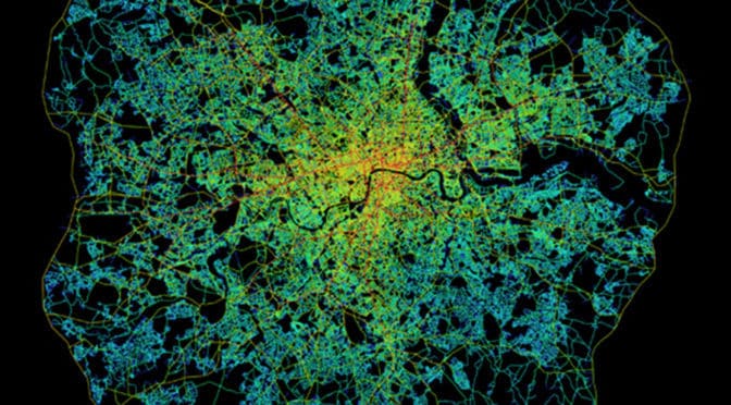
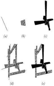
This is because urban space tends to be linear with streets, boulevards, avenues, and alleys but with only occasional (in relative terms) convex elements such as squares and public open space (Hillier, 2005). This can been seen most clearly in axial map of Greater London within the M25 (see below). The axial map represents the most optimal line of sight passing through every accessible space in the London street network until accounting for all accessible spaces and, then, measuring and graphically representing the spatial configuration of that network in terms of topological depth (see Space Syntax for Dummies, Part 2). Penn et al (1997) define the axial map as “the minimal set of axial lines such that the set taken together fully surveys the system, and that every axial line that may connect two otherwise-unconnected lines is included” (Turner et al, 2004: 428).

Space syntax model of Greater London within the M25 (Source: Space Syntax Limited and University College London).

Topological depth (refer back to the explanation in Space Syntax for Dummies, Part 2) can be measured based on global integration (or in topological terms, betweenness) because it measures the configurational relationship of all spaces to all others across the entire spatial network. It can also be measured to provide a more localized picture of spatial configuration by measuring local integration (or in topological terms, choice). The latter can be most easily understood if you imagine yourself standing at the intersection of two streets. Simultaneously, you are in and can see along the length of these two streets but also see all other streets – as well as other urban functions, i.e. level of use by people and cars, land uses, building heights. etc. – intersecting with them from your position. Or, topological depth can be measured in terms of radii between these two extremes. The space syntax model of Greater London within the M25 (see above) does so by limiting the radius based on the mean depth from the most globally integrated street; in this case, Oxford Street. The space syntax software automatically colors the degree of integration for each axial line. The color range is from red (most integrated) through orange, yellow, and blue, light blue, blue to purple (most segregated). At this point, the space syntax model is still a purely mathematical representation of configurational pattern. The analysis did not yet take in account other urban functions such as land use, building heights or population density though, of course, this information can be inputted into the model using GIS. Despite this, the axial map appears to provide a very realistic picture of how London operates as an urban spatial network.

An early key finding of space syntax research was establishing there is a relationship between the spatial configuration of the urban grid and patterns of pedestrian and vehicular movement (Hillier et al, 1993; Penn and Hillier, 1998). Penn and Hillier (1998) found that integrated spaces carry larger movement flows than more segregated ones, and the effects were strong and consistent. The key discovery was the correlation between movement flows and a purely configurational measure of the urban spatial network before ever taking into account the location of attractors or generators of movement. This led to the formulation of the theory of natural movement. The theory of natural movement states that movement patterns in the urban environment arise naturally from the way the urban grid organizes the simplest routes to and from all locations involving the fewest changes of changes in that grid. 
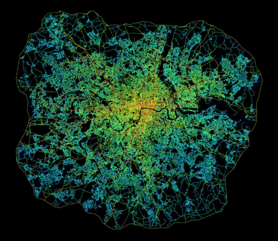
This means it is the design of the urban pattern in the shape of its grid that most matters. In this sense, natural movement is akin to a background effect of the urban grid since most movement in space will tend to be through-movement that is passing through a space on its way to somewhere else in the urban grid. The distribution of activities and land uses then has the potential to further intensify, or detract from, the background effects of natural movement (Hillier, 1996; Hillier and Vaughan, 2007).

A fundamental concept to arise from the theory of natural movement is the city as a movement economy. Namely, it is the pattern of the spatial network as generated by the urban grid, rather than the traditional planning emphasis on origin and destination matrices, which is the fundamental thing about the functioning of cities (Hillier, 1996). The urban grid generates a probabilistic but predictable pattern to the way people move through and occupy spaces in cities. Some spaces receive more movement and use because they are shallower within the spatial network whereas others are deeper and receive less. The spatial configuration of the urban grid generates a pattern of “attraction inequalities” whereby land uses tend to locate to exploit these potentials based on the pattern of natural movement (Hillier, 2002; 154). Retail will occupy more strategic locations to capitalize on the potential for passing trade. According to Hillier (2005), “this is not… to deny attraction… it is common sense (that) people make trips because the shops are there… but (attraction) is not fundamental” (11).

This early finding has led to a considerable body of research on how people move and occupy space, and the relationship to spatial configuration (see below and compare to the space syntax model of the Tate Gallery, Millbank in Space Syntax for Dummies, Part 1).

Routes of 100 people during the first 10 minutes of their visit to the Tate Gallery, Millbank (Hillier, et. al., 1996).

This simple introduction on The Outlaw Urbanist only begins to scratch the surface of the volume of research available from the use of space syntax over the previous 30 years. However, it should provide you with a solid foundation to jump into this vast collection of research, most of which is freely available online. For example, more than 500 research papers composing the proceedings of every Space Syntax Symposia for nearly twenty years is freely available for download via the Space Syntax Network here. Also, Chapter 3 of my forthcoming Relentless Magnificence: The American Urban Grid will delve more deeply into space syntax research and issues of methodology/terminology over the last 20 years.

Additional Reading and References
For your convenience, the easiest reading below is indicated with an *asterisk.

Hillier, Bill and L. Vaughan. 2007. “The city as one thing”, Progress in Planning, 67(3): 205-230. Article available online for download from University College London here.

Hillier Bill. 2005. “The art of place and the science of space”, World Architecture, Special Issue on Space Syntax. Beijing: 11(185): 24-34 (in Chinese); 96-102 (in English). Article is currently available online for download via the Scribd here. Registration required.

*Hillier Bill. 2002. “A theory of the city as object: or, how spatial laws mediate the social construction of urban space”, Urban Design International, 7: 153–179. Article available online for download from the Nordic Urban Design Association here.

*Hillier, Bill. 1996. Space is the Machine: A Configurational Theory of Architecture. Cambridge: Cambridge University Press. Digital eBook is available for free download from University College London here.

*Hillier, Bill, M.D. Major, J. Desyllas, K. Karimi, B. Campos, T. Stonor. 1996. Tate Gallery, Millbank: A Study of the Existing Layout and New Masterplan Proposal. Technical Report, Unit For Architectural Studies, Bartlett School of Graduate Studies, University College London. Report is available for free download from University College London here.

*Hillier, Bill, A. Penn, J. Hanson, T. Grajewski, J. Xu. 1993. “Natural Movement: or, configuration and attraction in urban pedestrian movement”, Environment and Planning B: Planning and Design, 20: 29-66. Article available online for download from University College London here.

*Major, M.D. 2014. Relentless Magnificence: The American Urban Grid. Jacksonville, Florida: Forum Books, forthcoming.

Penn, Alan, B. Hillier, D. Banister, Xu, J. 1998. “Configurational modeling of urban movement networks”, Environment and Planning B: Planning and Design, 25: 59-84. Article available online for download from University College London here.

Turner, Alasdair. 2004. Depthmap 4: A Researcher’s Handbook. Bartlett School of Graduate Studies, UCL, London. Handbook available online for download from University College London here.

Share the knowledge!
Share

Space Syntax for Dummies | Part 2 | Basics

Space Syntax for Dummies | Part 2
BASICS
by Dr. Mark David Major, AICP, CNU-A, The Outlaw Urbanist contributor

Continuing our three-part series on the basics of space syntax, Part 2 is based on excerpts from Chapter 3 of my forthcoming Relentless Magnificence: The American Urban Grid. As such, it is somewhat tailored to an American audience. The key principles discussed here are representation and configuration. What is configuration? In the simplest terms, using the most convenient definitions, configuration is not how one thing relates to another thing but how that one thing relates to all other things and also how all those other things relate to each other.

Basic representations of space syntax: (a) axial line; (b) convex space; (c) visual field or an “isovist” (after Benedikt, 1979); or used in tandem (d) axial lines passing through convex spaces; and (e) isovist from a convex space.

According to space syntax theory, a key to understanding urban space is a description not just of the individual elements in the city (this street or that square) but a description of the entire spatial system considered as a configurational network. Over the last three decades, spaces syntax research programs around the world have developed a series of representational and analytical techniques based on simple descriptions of space (Hillier and Hanson, 1984; Hillier, 1996; Hanson, 1998). By simple description, we mean representations that obey real physical constraints the built environment places on visibility and movement since you cannot see and move through solid objects but only through open and accessible space. First, the movement of a person or persons through the built environment tends to be linear so one representation used is the axial line or axis (see ‘a’ above). The matrix of the longest and fewest lines of sight and access that completely encompasses all the spaces of a built environment is the axial map. Second, previous research has found the occupation of space by people in the built environment will tend towards convexity, the mathematical definition of all points being visible to all others, such as a group of people gathered in a circle (Hillier et al, 1996; Campos, 1997). This simple description is a convex space (see ‘b’ above). The collection of the fattest two-dimensional lumps of space, or convex spaces, in a built environment is the convex map. Finally, the potential for seeing and moving in the built environment can also form the basis for a simple description of space, which Benedikt (1990) called the isovist or, more simply, the visual field at eye level (see ‘c’ above) (Hillier et al, 1987; Conroy Dalton et al, 2003). An isovist describes all visible and accessible space to which a person or persons might move as defined from a particular point or set of points. 
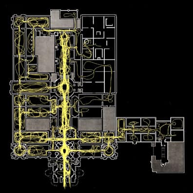
Later methodological developments in space syntax allow for the measurement of the configurational relationship of all visual fields from a gridded set of points (or point isovists) to all others in a built environment. These form a matrix of visual fields where some are more strategic than others for understanding the spatial network as a whole (see the space syntax model of visual fields in the Tate Gallery, Millbank in Space Syntax for Dummies, Part 1). This is a visibility graph (Turner and Penn, 1999). Finally, any combination of these representations can be used to create a more complex picture of the built environment, depending on the problem researched (see ‘d-e’ above). Hillier (2005) describes these simple descriptions as “a natural and necessary spatial geometry (which) describes some aspect of how buildings and cities are organized… as a vital aspect of how we create them, use them and understand them” (5). This is how to represent space.

However, some additional clarification is required about what is meant by configuration. Configuration is a relational system based on topological graph theory whereby any local changes in that system can have global effects across that system (Hillier, 1993; Hillier, 1996).

Configuration: (top) Relation between two objects so ‘a’ is to ‘b’ as ‘b’ is to ‘a’; (bottom left) A configurational relationship is created in relation to a third object, such as the surface of the Earth; (bottom center) Connection or permeability changes the configurational relationship between the three objects so all are equally shallow from the other; or, (bottom right) an asymmetrical relationship between the three objects whereby ‘b’ or ‘c’ can only be reached via ‘a.’

For example, two objects are in a mathematical relationship to each other so it can be said that ‘a’ is to ‘b’ as ‘b’ is to ‘a’ (see above, top). Once this relationship is established with reference to a third object, in this case the surface of the earth, there is a configurational relationship (see above, bottom). If the objects are distinct, then it can be said ‘a’ is to ‘c’ as ‘b’ is to ‘c’ but, in order to reach ‘a’ from ‘b’ or vice versa, one has to pass through ‘c’. This can be seen more clearly in the corresponding topological graph where ‘c’ is shallower to ‘a’ and ‘b’ than they are to each other. The depth of ‘a’ or ‘b’ to any other object in the system is three whereas the depth from ‘c’ to ‘a’ or ‘b’ is two and total depth in the system of objects is eight. Next, ‘a’ and ‘b’ can be placed next to each other to introduce the idea of permeability or connection into the system of objects. The objects are in a symmetrical relationship where all spaces are maximally shallow from each other, so that ‘a’ is to ‘b’ as ‘b’ is to ‘c.’ In this case, the depth from any object to any other is two and total depth in the system is six. Finally, if ‘b’ is placed on top of ‘a’, this forms an asymmetrical relationship with reference to ‘c.’ You have to pass through ‘a’ in order to reach ‘b’ from ‘c’ or vice versa but you are not required to pass through ‘b’ to go from ‘c’ to ‘a.’ In this case, the depth of ‘b’ and ‘c’ is three and depth from ‘a’ is only two. Total depth in this asymmetrical relationship is eight (Major, 2000). According to Hillier (2005), “space syntax seeks to formulate mathematically the configurational properties of space that we intuit, as manifested in the way… we construct real spatial patterns through building and cities” using topological graph theory to objectively measure these spatial patterns (6).

These are the basic principles underlying space syntax.

Additional Reading and References
For your convenience, the easiest reading below is indicated with an *asterisk.

Benedikt, Michael L. 1979. “To take hold of space: Isovists and Isovists Fields”, Environment and Planning B: Planning and Design, 6: 47-66. Article is currently available online for download from the Massachusetts Institute of Technology here.

Campos, Maria Beatriz de Arruda. 1997. “Strategic Space: Patterns of Use in Public Square of the City of London”, First International Space Syntax Symposium Proceedings (Eds. M.D. Major, L. Amorim, F. Dufaux), 2: 26.1-26.11. Article is currently available online for download via the Space Syntax Network here.

Conroy Dalton, Ruth and S. Bafna. 2003. “The syntactical image of the city: A reciprocal definition of spatial elements and spatial syntaxes”, Fourth International Space Syntax Symposium Proceedings, London, 2003: 59.1-59.22. Article is currently available online for download via the Space Syntax Network here.

Hanson, Julienne. 1998. Decoding Homes and Houses. Cambridge: Cambridge University Press. Available for purchase from Amazon here.

Hillier Bill. 2005. “The art of place and the science of space”, World Architecture, Special Issue on Space Syntax. Beijing: 11(185): 24-34 (in Chinese); 96-102 (in English). Article is currently available online for download from Scribd here. Registration required.

*Hillier, Bill. 1996. Space is the Machine: A Configurational Theory of Architecture. Cambridge: Cambridge University Press. Digital eBook is available for free download from University College London here.

*Hillier, Bill, M.D. Major, J. Desyllas, K. Karimi, B. Campos, T. Stonor. 1996. Tate Gallery, Millbank: A Study of the Existing Layout and New Masterplan Proposal. Technical Report, Unit For Architectural Studies, Bartlett School of Graduate Studies, University College London. Report is available for free download from University College London here.

*Hiller, Bill, J. Hanson, H. Graham. 1987. “Ideas are in things: an application of space syntax method to discovering housing genotypes”, Environment and Planning D: Planning and Design, 14: 363-385. Article is available for free download from University College London here.

Hillier, Bill and J. Hanson. 1984. The Social Logic of Space. Cambridge: Cambridge University Press. Available for purchase from Amazon here.

*Major, M.D. 2014. Relentless Magnificence: The American Urban Grid. Jacksonville, Florida: Forum Books, forthcoming.

Turner, Alasdair and A. Penn. 1999. “Making Isovists Syntactic: isovist integration analysis”, Second International Space Syntax Symposium Proceedings (Eds. F. de Holanda, L. Amorim, F. Dufaux), 1:11.01-11.14. Article is currently available online for download via the Space Syntax Network here.

Stay tuned for Space Syntax for Dummies, Part 3: Results.

Share the knowledge!
Share