“Come and keep your comrade warm,
I’m back in the U.S.S.R.
Hey you don’t know how lucky you are boys,
Back in the U.S.S.R.”
— Back in the U.S.S.R., The Beatles
Urban Patterns | Petropavlovsk-Kamchatsky, Russia
by Dr. Mark David Major, AICP, CNU-A
NOTE: Urban Patterns is going to focus on more obscure and/or extreme locations in a number of posts over the next few weeks.
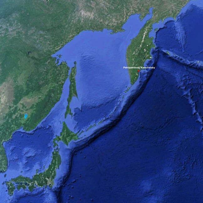
Petropavlovsk-Kamchatsky is located on the Avacha Bay along the Pacific Coast of Russia on the Kamchatka Peninsula to the northeast of Japan. The city and peninsula are located several hundred miles to the west of an extent of the Mariana Trench in the Pacific Ocean (see above). The Mariana Trench is where the Pacific plate dives under the Asian plate on the Earth. Because of this, several hundred miles to the west are a series of volcanoes generated by plate tectonics, the most famous of which is probably Mount Fuji outside of Tokyo, Japan. Petropavlovsk-Kamchatsky has a population of more than 178,000 (the overwhelming majority of which are ethnic Russians and Ukrainians), which serves as the cultural and administrative center of the Kamchatka Krai (a krai is an administrative division of the Russian Empire). In fact, more people live in the city than in the entirety of the peninsula. However, the city’s population has declined by almost 100,000 people over the last 20 years. Russia’s (and the former Soviet Union) largest submarine base is located on Avacha Bay across from Petropavlovsk-Kamchatsky. The city was founded by Danish navigator Vitus Bering in the service of the Russian Navy in 1740.
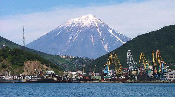
He named the new settlement “Petropavlovsk” (Peter and Paul) after his two ships, the St. Peter and the St. Paul. In addition to serving as an administrative center and providing infrastructure support for the Russian Navy, Petropavlovsk-Kamchatsky’s main commercial industry is fishing, salmon and crab meat in particular. Petropavlovsk-Kamchatsky is characterized by a subarctic climate and about three-and-a-half times more snow falls in this area compared to Siberia though, due to its location, temperatures are much milder year-round. Due to plate tectonics, Petropavlovsk-Kamchatsky is surrounded by high hill and volcanoes; see the header image of Petropavlovsk and Koryaksky Volcano, as seen from Avacha Bay (Source: Wikipedia).
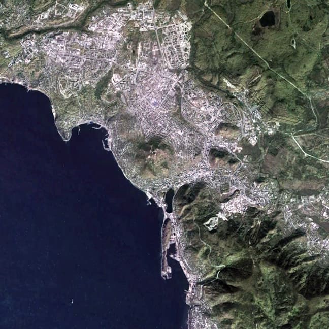
Because of this, the urban grid in the city is characterized by two attributes: first, a large extent of roads throughout the city and along the coast curving in relation to elevation changes in the area, as seen in other hilly cities around the world, which Moholy-Nagy referred to as a “geomorphic” pattern; and second, the deformation of a series of small-scale regular grids to optimize the buildable area on the flatter terrain, particularly inland to the northeast of the original town. The oldest part of the city is located directly on the bay, east of the smaller peninsula extended and made somewhat more ‘regular’ in shape by the intervention of man over the previous 250 years, i.e. at the lower center of the above image.
(Updated: July 2, 2017)
Urban Patterns is a series of posts from The Outlaw Urbanist presenting interesting examples of terrestrial patterns shaped by human intervention in the urban landscape over time.