Tag Archives: tourists

FREE COURSE | Following the Crowd | Movement, Space Use, Risk Management

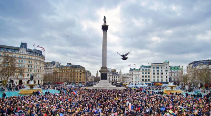
Following the Crowd | Movement, Space Use, Risk Management examines movement, congregation and space use in crowd phenomenon based on two studies in London during the late 1990s. The first was New Years Eve celebrations in central London and the second is the ‘Diana phenomenon’ of crowd gatherings in public displays of mourning in Kensington Gardens. The course argues two points. First, clearly, there are crowd characteristics particular to specific events, i.e. number of people, time factors, and crowd management measures. Second, many crowd characteristics often represent only a dramatic, temporary intensification of everyday circumstances in urban conditions, which has implications for recent pedestrian-oriented design concepts such as shared space (2.0 hour course).

NOTE: This course makes selective use of space syntax. Even if you are not familiar with space syntax, the subject matter should not be considered a deterrent.

Key concepts: crowds, movement, occupation, police, risk management, urban design.

Instructor: Dr. Mark David Major, AICP, CNU-A

Check here to purchase this  course (FREE registration required), which includes an two hour video presentation and PDFs of the course supplementary materials and slide handout.

Share the knowledge!
Share

NOW AVAILABLE | Reactivating the Riverfront, 1990-2015

Reactivating the Riverfront, 1990-2015 covers some design, planning, and regulatory strategies deployed to reactivate the riverfront in Central London. London is a metropolitan region of nearly 14 million people covering over 3,000 square miles where redevelopment involves a dizzy array of design, social, economic and political factors, especially in the post-war period. 
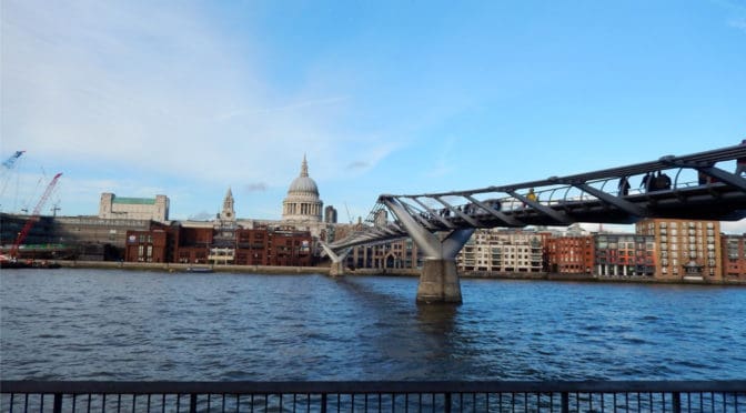
The course narrowly focuses on one particular aspect of redevelopment in that city over the last 25 years by examining five or six projects (depending on how they are parsed) on three sites from Westminster Bridge in the southeast to Tower Bridge in the northwest that proved crucial for revitalizing urban life along the River Thames (1.0 hour course).

Key concepts: Section 106 Agreement, pedestrian movement, tourists, locals, circuiting, river access.

Instructor: Dr. Mark David Major, AICP, CNU-A

Check here to purchase this course ($9.99), which includes an one-hour video presentation and PDFs of the course notes and slide handout.

Note: We are beta-testing with these initial course offerings so if you have any issues accessing the course material, please do not hesitate to contact us at [email protected]. Thank you!

Share the knowledge!
Share

Urban Patterns | Disneyland | Anaheim | California USA

“Jack be nimble, Jack be quick. Ohhhh.
Take a ride on the West Coast kick. Ohhhh.
Holiday roooooaaaad, ohhhhh.”
— Holiday Road, Lindsey Buckingham

Urban Patterns | Disneyland | Anaheim | California USA
by Dr. Mark David Major, AICP, CNU-A

Purportedly the happiest place on Earth, Disneyland is located in Anaheim, California about 30 miles from Downtown Los Angeles. Opened in 1955, Disneyland is the only theme park designed and built under the direct supervision of Walt Disney. Walt Disney came up with the concept after visiting various amusement parks with his daughters in the 1930s and 1940s. He initially envisioned building a tourist attraction adjacent to his studios in Burbank to entertain fans who wished to visit; however, he soon realized that the proposed site was too small. After hiring a consultant to help him determine an appropriate site for his project, Disney bought a 160-acre (65 ha) site near Anaheim in 1953. Construction began in 1954 and the park was unveiled during a special televised press event on the ABC Television Network on July 17, 1955 (Source: Wikipedia).

Satellite view from 2.5 km of Disneyland in Anaheim, California in 2013 (Source: Google Earth).

It is not a surprise to discover acres of surface parking servicing the park, which also represents the hottest place in the urbanized areas of Southern California (literally, not metaphorically). The pink ramparts of the Disney castle are visible in the center of the above image. The overall shape of the original park was circular (discounting later expansions) with the famous Disney Main Street running from the main gate in the south towards the north, defining a ceremonial axis that terminates on the castle. Pirate’s Lair on Tom Sawyer Island (see Mark Twain’s The Adventures of Tom Sawyer) is located to the northwest of the park. Tomorrowland is located to the eastern edge of the park (though I suppose nowadays it could be more easily called Todayland). The highway adjacent to Disneyland at its eastern edge is Interstate 5 aka Santa Ana Freeway. To get there from Santa Monica: take Olympic to I-10, then to I-5 south but avoid the 4-0-5 at all costs, like fer sure.

(Updated: June 25, 2017)

Urban Patterns is a series of posts from The Outlaw Urbanist presenting interesting examples of terrestrial patterns shaped by human intervention in the urban landscape over time.

Share the knowledge!
Share