Urban Patterns | New York, New York USA

“Even old New York was once New Amsterdam,
Why they changed it, I can’t say,
People just liked it better that way.”
Istanbul (Not Constantinople), They Might Be Giants (BTW, now in San Francisco)

Maybe you were expecting this…

“These vagabond shoes are longing to stray,
Right through the very heart of it: New York, New York.”
New York, New York, Frank Sinatra

Urban Patterns | New York, New York USA
by Dr. Mark David Major, AICP, CNU-A

New York is the most populous city in the United States. With an estimated 2016 population of 8,537,673 distributed over a land area of about 302.6 square miles (784 km2), New York City is also the most densely populated major city in the United States. Located at the southern tip of the state of New York, the city is the center of the New York metropolitan area, one of the most populous urban agglomerations in the world. New York City exerts a significant impact upon commerce, finance, media, art, fashion, research, technology, education, and entertainment around the world; its fast pace defining the term “a New York minute.” Home to the headquarters of the United Nations, New York is an important center for international diplomacy and has been described as the cultural, financial, and media capital of the world. Dutch merchants and settlers originally founded New York (originally named New Amsterdam) – along with three other Dutch forts in present-day New York State – on Manhattan Island at the conflux of the Hudson and East Rivers into a natural harbor at Upper New York Bay in 1625. As evidenced in the Castello Plan (see below), the early settlement was composed of small-scale offset regular-ish grids oriented to the shoreline of the Hudson and East Rivers at the southern tip of Manhattan Island (Source: Wikipedia).
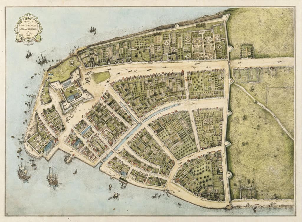
Redraft of the Castello Plan of New Amsterdam in 1660, redrawn in 1916 by John Wolcott Adams and Isaac Newton Phelps Stokes (Source: Wikipedia).

Over the first 100 years of the settlement, this geometric layout (in the modern Wall Street area) evolved into a classic, European deformed grid pattern. In planning terms, Manhattan is probably best known for the 1811 Commissioners Plan (see here for more information), which imposed a gridiron over most of the island north of the Wall Street area.
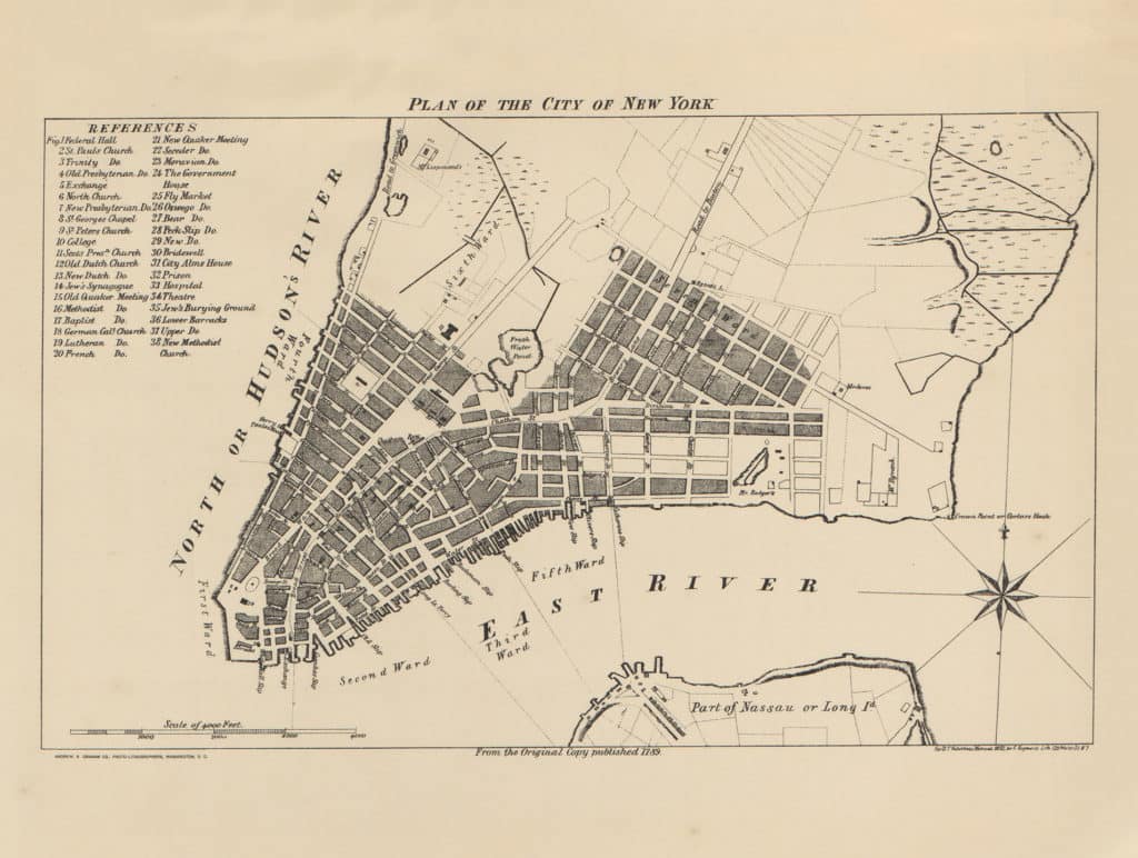
1789 Plan of New York, New York USA (Source: University of Texas).

However, as evidenced by historic plans of New York such as the 1789 plan of southern Manhattan (see above), this gridiron was really an extension of an already-existing regular grid immediately north of that area, predating the Commissioners Plan by two decades.
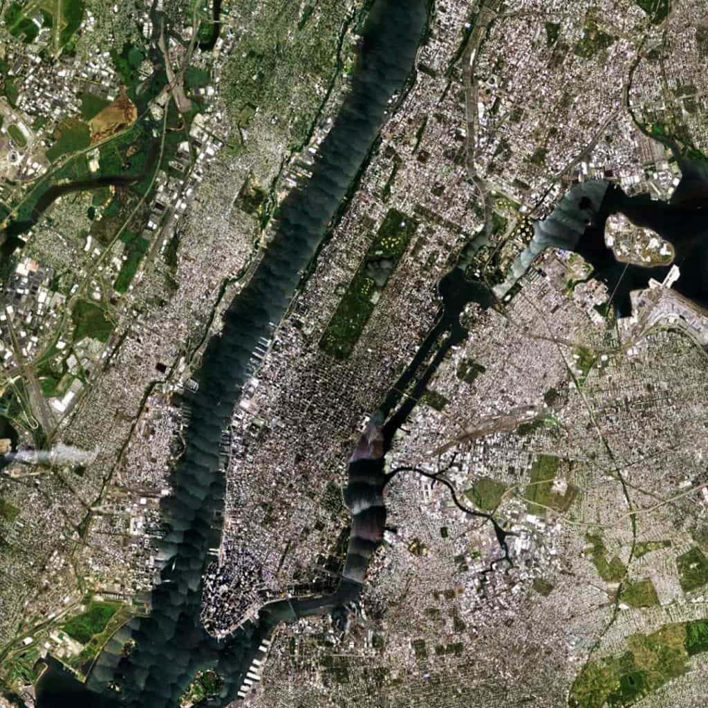
Satellite view from 20 km of New York, New York USA (Source: Google Earth).

The overall linear (more or less, south to north) shape of the island was well-suited for regular grid extension, especially in the middle portion of the island around Central Park. At 843 acres, Central Park (designed by landscape architect Frederick Law Olmsted and the English architect Calvert Vaux) is still one of the largest urban parks in the world and the most visited park in the United States. Architects and planners often discuss the planning of Manhattan to the exclusion of its larger urban context (especially in discussing the 1811 Commissioners Plan). However, the island is well-embedded within its larger urban context, possessing some 19 bridge and tunnel connections to the surrounding area, especially to the north of the island where 12 (63%) of these connections are available.

(Updated: August 14, 2017)

Urban Patterns is a series of posts from The Outlaw Urbanist presenting interesting examples of terrestrial patterns shaped by human intervention in the urban landscape over time.

Share the knowledge!
Share

On Space | A Sensory City of Theory

On Space | A Sensory City of Theory
by Dr. Mark David Major, AICP, CNU-A

Building transmutes the ideal into the selectively practical. Architecture asserts the hypothetical into creative sensation – of space, of light, of form, of transformation, of shapes frozen and in motion – and the city is born. The architect and planner re-assert the sensory into the theoretical, and the organism of the city is invigorated and renewed. The genesis of this association lies in the imagination of human intellect and the practicality of the human hand. It is not a mysterious alchemy, revealed to only a privileged few. It is a delightful synthesis of the human condition in which we are all are invited to participate. Space is both the medium and crucible of this association. Space surrounds and embeds the condition with meaning – within and extraneous – simultaneously internal and external to the object whilst also being native and foreign to its subject. It is future prologue and past epilogue of the same problem. In the city, this paradox is played on a grid of streets, geometrical in nature, intrinsically to the street itself and extrinsically in the relation of one to all others. This nature exists in a continuum, an axis drawn between the extremes of conserved chaos and radical order. Our errors in comprehending this ordered chaos, what Jane Jacobs once referred to as “organized complexity”, lies within the self-imposed boundaries of our own descriptions. We become limited in describing that which we wish to see instead of observing that which we wish to understand and, in doing so, we become trapped within the tired dogmas of an imagined past and a condemned future.

Dogma selects us. We do not choose the doctrine. This often (preferably) occurs independently of curiosity or wisdom and we youthfully mistake its favors as a proclamation that, indeed, we are the anointed one. It is a false image of oneself. Once a single step is taken along this path, we derive words inadequate to the object but sufficient for dogmatic pursuit in a hollow attempt to describe the nature of the city and make the understandable, the objective, into the incomprehensible, the subjective. We move backward and abnegate the hypothetical for the fanciful, the sensory for the material, and theoretical for the dogmatic. In doing so, we attempt to surround ourselves in meaning at the expense of the spatial and the urban. Theory suffocates in the vacuüm of this confrontation, embracing a void that fails the essential, instinctive construction of the city, in service to the super-ego of the individual. The urban loses balance. The real nature of the city hides behind a mask, a voice without a face, raising objections to the elementary urbane on shallow grounds of methodological peculiarities, historical reinterpretations, and narrow understandings of the relation between form and function. We must not fear to finally unmask the charlatan to unveil the bodily and mentally sensual to the masses, and declare the sensory city as a subject that is worthy of investigation and a thing demanding objective theory. In this way, the investigative and the theoretical form a synthesis to reveal the functional significance of space. Our words must have the precision and structure of whispers so that our theories carry meaning beyond the lone voice screaming to be heard above the crowd. We are the crowd, and it is our voices that matter.

On Space is a regular series of philosophical posts from The Outlaw Urbanist. These short articles (usually about 500 words) are in draft form so ideas, suggestions, thoughts and constructive criticism are welcome.

Share the knowledge!
Share

More Poor Richard | Part 1

More Poor Richard, Part 1
by Dr. Mark David Major, AICP, CNU-A, The Outlaw Urbanist contributor

Courteous Reader,

I attempted to win your favor when I wrote my first Almanac for Architects and Planners, in the name of the public good and professional betterment, by way of earning some profit and a wife. I am gratified by your expression of encouragement for my tireless efforts dedicated to these aims. Alas, my circumstances still find me exceedingly poor and, unluckily, exceedingly wifeless. I am required to earn some profit to address both problems whilst now addressing a third, namely testing the proposition that insanity is “doing the same thing over and over again and expecting different results.” To satisfy my own particular brand of insanity, I have written more proverbs and whimsical sayings for your benefit and, hopefully, my own.

As before on The Outlaw Urbanist, I write this new Almanac in increments of ten, according to the dictates of Moses and the Almighty. However, once published as an Almanac for Architects and Planners, the proverbs and witticisms were gathered into a number equal to the days of the week, after being reliably informed that both seven and ten are sacred numbers. My desired requirement for a wife is sufficient motive to write this new Almanac in the hope it will find your favor and retweets as a means of demonstrating the usefulness of my continued efforts but also your charity to this sane Friend and poor Servant,

Richard

On Cities

1.    As big as the road, so will the car be.

2.    When American urban designers and planners developed an allergic reaction to straight lines and right angles, our cities started sneezing phlegm all over the place.

3.    A ‘road to nowhere’ is much less important than all the ‘somewheres’ it will eventually lead.

4.    Suburban sprawl breeds idiotic driving behaviors.

5.    Interruptus en extremis isn’t any good for urban life… or your sex life.

6.     Pursuing (politically palatable) green spaces to the exclusion of (hard choice) urbanity is a self-defeating proposition. We have that, it’s called suburban sprawl.

7.     Observe the world around you before daring to create anew.

8.     Every city should have at least one Electric Avenue we gonna rock down and then take it higher… perhaps even two.

9.     The pattern of great cities is at once sensuous and logical; elegant with the past, restless in the present, and pregnant with future potential.

10.    Part is to whole as whole is to part in the city.

Issue 2 of More Poor Richard for Architects and Planners cometh soon!

Share the knowledge!
Share

Algorithmic Space | The City in Art

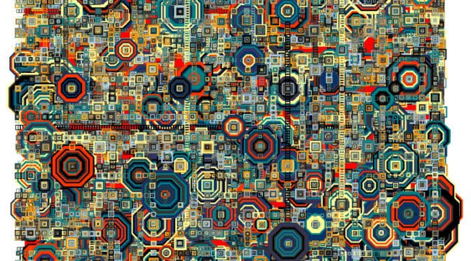
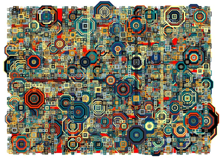
Don Relyea’s Cityscape with Helipads and Ladders (2011), www.donrelyea.com.

“They don’t know what you’re doing, Babe, it must be art.”
– Hold Me, Thrill Me, Kiss Me, Kill Me, U2

Algorithmic Space | The City in Art
by Dr. Mark David Major, AICP, CNU-A

Don Relyea’s Cityscape with Helipads and Ladders (2011) uses an algorithm based on the Hilbert space filling curve, discovered by mathematician David Hilbert. The version of Relyea’s program subdivides spaces within the total space to be filled and runs the algorithm to fill the smaller spaces separately. Each smaller space is centered on a point on the curve causing the smaller renderings to intersect the larger one in interesting ways. The program recursively draws rectangles along the curve. At certain times during the execution, it draws larger concentric rectangles and connects special points with trailed concentric rectangles (Source: www.donrelyea.com).

I am not even going to pretend to understand the mathematics of what Relyea is describing, except in only the vaguest sense. I’m sure Dr. Nick “Sheep” Dalton and Dr. Ruth Conroy Dalton would understand the mathematics of Relyea’s generative algorithm, and I will get them to explain it to me the next time I see them. For those interested in the mathematics of the algorithm, there is more information available here. However, purely in terms of art, Relyea’s generative algorithm appears to capture something of the “organized complexity” of the city, which is, no doubt, why Relyea decided to appropriately title his computer-generated art series as “cityscapes”. In addition to this generative complexity, Relyea’s prints also capture something of the repetitiveness of city space, which Relyea varies through his use of color (see the entire series to date here). It is suggestive there are more practical applications for his generative algorithm in urban modeling and science, beyond that of generating complex shapes for artistic reasons. However, based purely on artistic terms, the result is a compelling abstract image of repetitive complexity.

About Don Relyea
Don Relyea graduated from Southern Methodist University in 1992, where he was a print making major and information systems major and a merit scholarship student. He lives and works in Dallas Texas USA with his wife and three kids. Upon graduation, Relyea immersed himself in the multimedia software industry producing video and interactive CD content and eventually games for publishers and clients. In the multimedia industry, he developed a love for programming graphics on computers and now produces art in several media both traditional and digital. Relyea focuses in the area of computational art. He writes his own custom art software in C++ and Open GL. Many of the programming techniques Relyea learned in game development he now employs with his art, primarily producing prints and video art. He often weaves cultural, social and political dimensions into his work. Nature and mathematical forms are also common subjects. His print and video work have been in exhibited in galleries and juried exhibitions all over the United States. Recently, Relyea’s video art has been installed outdoors in curated/juried shows in Oslo, Norway, The Hague, the Digital Graffiti Festival at Alys Beach Florida, W hotel in Seoul Korea and International Free Exchange Zone in Incheon Korea (Source: www.donrelyea.com).

The City in Art is a series by The Outlaw Urbanist. The purpose is to present and discuss artistic depictions of the city that can help us, as professionals, learn to better see the city in ways that are invisible to others. Before the 20th century, most artistic representations of the city broadly fell into, more or less, three categories: literalism, pastoral romanticism, and impressionism, or some variation thereof. Generally, these artistic representations of the city lack a certain amount of substantive interest for the modern world. The City in Art series places particular emphasis on art and photography from the dawn of the 20th century to the present day.

Share the knowledge!
Share

Urban Patterns | Vienna, Austria

“Now in Vienna there are ten pretty women,
There’s a shoulder where Death comes to cry.”
Take this Waltz, Leonard Cohen

Urban Patterns | Vienna, Austria
by Dr. Mark David Major, AICP, CNU-A

Vienna is the capital and largest city of Austria with a population of about 1.8 million (2.6 million within the metropolitan area, nearly one-third of Austria’s population), and its cultural, economic, and political center. It is the 7th-largest city by population within city limits in the European Union. There is evidence of continuous habitation in Vienna since 500 BC when the site on the Danube River was first settled by the Celts. In 15 BC, the Romans fortified the frontier city they called “Vindobona” to guard the empire against Germanic tribes invading from the north. Vienna is known for its high quality of life. In a 2005 study of 127 world cities, the Economist Intelligence Unit ranked the city first (in a tie with Vancouver, Canada and San Francisco, USA) for the world’s most liveable cities (Source: Wikipedia).

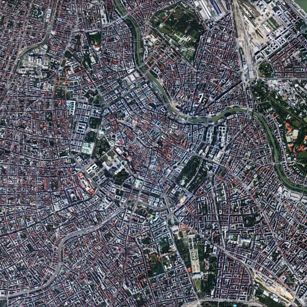
Satellite view from 5 km of Vienna, Austria (Source: Google Earth).

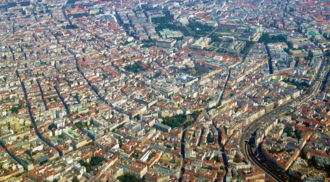
The urban layout of Vienna is a classic European deformed grid with a series of open-angled diagonal routes radiating outward from center-to-edge and intersecting/overlaying with a series of ring/orbital roads, which similarly radiate outwards based on an increasing radius from center-to-edge, i.e. smaller rings in the center, successively larger in the periphery. As in other European cities, the deformed grid pattern in the oldest area of the city (more or less center above) is composed of smaller blocks and shorter streets. As the city has grown in size, the size of blocks and length of streets (and associated segments) have increased, which embeds the layout with a strongly consistent geometric logic (especially when blocks are examined in discrete terms) in its deformed grid pattern.

(Updated:  May 18, 2017)

Urban Patterns is a series of posts from The Outlaw Urbanist presenting interesting examples of terrestrial patterns shaped by human intervention in the urban landscape over time.
Share the knowledge!
Share

Blogging about architecture, urbanism, and culture…

Share