Urbanists Branded as Outlaws for Bluntly Speaking Truth | Urbanism Speakeasy
Mark David Major recently made an appearance on the podcast, Urbanism Speakeasy.
Excerpt:
“We are outlaws. So says a passionate group of bloggers who have been challenging status quo infrastructure planners and designers. Mark David Major joins the Urbanism Speakeasy this week. He is the principal blogger and co-founder of The Outlaw Urbanist.”
On Space | The Phenomena of Space by Dr. Mark David Major, AICP, CNU-A
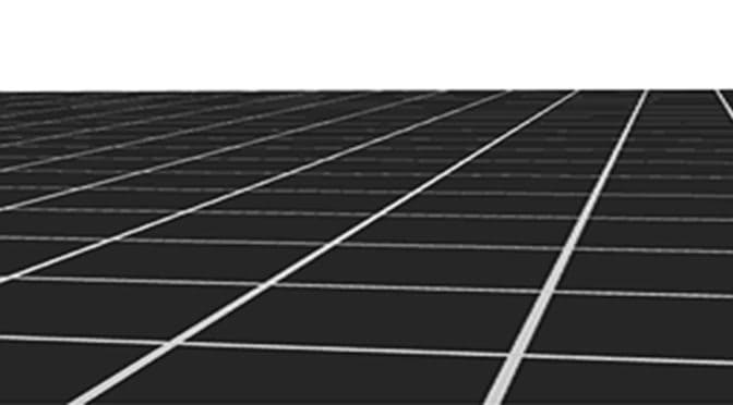
The character of space is innately capable of diagnostic exploration. Its mystery only derives from our own inexperience of life, obscuring phenomena otherwise naked to the human eye. Space is simultaneously independent of our actions and dependent on the reaction, Irresistible and immovable is its nature. These characteristics are composed of both semantic qualities of the eye and syntactic quantities of the mind, given purpose in deed and meaning in effect. It can be partially measured in Cartesian terms, partially valued within the constrictive boundaries of a narrow class of types, but only fully contemplated in mathematical scales of size and shape. Only in this manner can we ‘un-hole’ our understanding of space. We must stop digging. We must stop coloring within the lines of mistaken conceptions about space. We must embrace the knowable unknowns; bring the disposition of space closer to our hearts to receive the epiphany that will shake the foundations of the building professions. Space is a material thing, a thing of substance, of quantity and quality that begs for our description, for our understanding, and for our reasoned implementations. We must reduct to deduct but deduction in the absence of product is a shadow, without meaning or substance. It becomes an empty vessel waiting to be filled. If we leave an empty receptacle for the citizenry, detached from the meaning of built space, to connote and denote, then it shall be filled for us, often with dire unintended consequences for our spatial experience. We cannot skate our way to spatial freedom but only walk the path of its responsibilities.
These characteristics are of the mind and the hand, working in concert in the creation and evolution of society. We must become more aware of these consequences, of size and shape, of elongating or compacting, or dispersal or density. Size does matter not only in its measurement but also and mainly in the reaction as a contextual consequence. The line of the street in its horizontal and vertical dimension is worthy of examination as a discrete entity. However, absent of the network, its nature holds the absence of repercussion. It becomes a discordant beat, empty of its counterpoint, to generate a rhythm to the movements of life. We prescribe the false illusion of a static energy that cannot bear the weight of all the potential energy pervading the life force of the city, a place, a dwelling, or a people. We lose the connection between our constructions and ourselves; between each other; between them and us; and, between the invisible entity within which we reside and the Other within all of us. It is only when we liberate ourselves from our preconceptions and misconceptions that a true portrait of our spatial being can emerge from a multitude of brushstrokes. Then the generation and evolution of space will become a knowable known, spoken of in clarity, and not merely unconsciously practiced by rote. The spatial phenomena will be unveiled, unmasked, unhidden from our consciousness and its true beauty can be exalted and celebrated.
On Space is a regular series of philosophical posts from The Outlaw Urbanist. These short articles (usually about 500 words) are in draft form so ideas, suggestions, thoughts and constructive criticism are welcome.
Las Vegas is a source of fascination. It has been since the publication of Learning from Las Vegas in 1972. Some say Las Vegas is “the way you’d imagine heaven must look at night.” Norman Mailer describes the city thus; “the night before I left Las Vegas I walked out in the desert to look at the moon. There was a jeweled city on the horizon, spires rising in the night, but the jewels were diadems of electric and the spires were the neon of signs ten stories high.” Alistair Cooke observes, “Las Vegas is Everyman’s cut-rate Babylon… (there was) a roadside lunch counter and over it a sign proclaiming in three words that a Roman emperor’s orgy is now a democratic institution: Topless Pizza Lunch.” Cooke implies waitresses were serving pizza sans clothing but it could have meant the roadside lunch counter was serving its pizza lunch sans toppings, i.e. Margherita. Given Las Vegas’ reputation, it is probably wise to assume both options were on the menu. In any case, architects and urban planners have shared this fascination with the ‘Modern Babylon’ of Western civilization.
Learning from Las Vegas narrowed its arguments against the precepts of Modernism in favor of a new theoretical approach. The emergence of Post-Modernism as a distinctive architectural style overshadowed some of the most remarkable things in that book. This unsurprising since the point of examining the “phenomenon of architectural communication” where the “symbol in space (comes)
Urban Pattern in the 1960s: Figure-ground representation of building footprints along the Las Vegas Strip during the late 1960 (Venturi, et. al, 1972).
before form in space” in Las Vegas and, specifically the famous Strip, was to expand to the urban level a theory Robert Venturi had already outlined in 1966’s Complexity and Contradiction in Architecture. The preoccupation with the semantics of architectural form in Post-Modernism – and its successor, Deconstructivism – took to heart what Learning from Las Vegas showed us to the exclusion of what was said. For example, there is an implicit acknowledgement of a spatial dimension to the pattern of urban functions in Las Vegas. Namely, “a set of intertwined activities that form a pattern on the land… the Las Vegas Strip is not a chaotic sprawl but a set of activities whose pattern, as with other cities, depends on the technology of movement and communication and the economic value of land.” The book also extensively uses plan representations such as figure-grounds to reveal crucial information about the functional structure of urban space in Las Vegas during the late 1960s.
Las Vegas Today: Parks, airports, and interstate highways overlaying a space syntax model of Las Vegas street network.
This is a little remarked upon yet still remarkable concession, i.e. more than semantics is going on in Las Vegas. Albert Pope seizes on this concession in Ladders (1996) to argue the “urbanism of the Strip was itself structured on a relentless linear armature… in contrast to the original Las Vegas gridiron and the pedestrian ‘strip’ of Fremont Street, the organization of the upper strip was a discrete and reductive axis of development – a complete linear city.”
In hindsight, the flaw of Learning from Las Vegas is taking an urban object as a subject before its time. Las Vegas is more fascinating today than five decades ago because it represents a quintessential example of American development during the post-war period. We say this because the city is spatially transcendental. This means first, the city is characterized by congruent spatial networks occupying (grossly) the same point in space/time and second, these spatial networks exist a priori and emerge as a consequence to urban growth. By congruent, we mean coinciding at all points in terms of location since one is super-imposed over the other. The a priori conditions are a consequence of the pattern of land division imposed by the 1785 Land Ordinance. Using computer modeling such as the configurational software of space syntax, we can ‘peel’ these congruent spatial systems apart and examine their role in Las Vegas; much like peeling layers off an onion and examining the individual layers (we know together they form an onion). The results are fascinating. First, Las Vegas has a well-defined, center-to-edge spatial pattern, the focus of which is not the Las Vegas Strip (though it is partially in the core) but the historic area/Central Business District (CBD). Second, a congruent, large-scale orthogonal spatial pattern emerging from the pattern of land division over time characterizes Las Vegas. This orthogonal grid pattern did not exist in the early 20th century (though we can infer its outline from section lines) and only began to emerge during the 1950s and 1960s before fully manifesting in the late 20th century.
Las Vegas Yesterday: Las Vegas in 1908 (left) and 1952 (right) (Source: US Geological Survey).
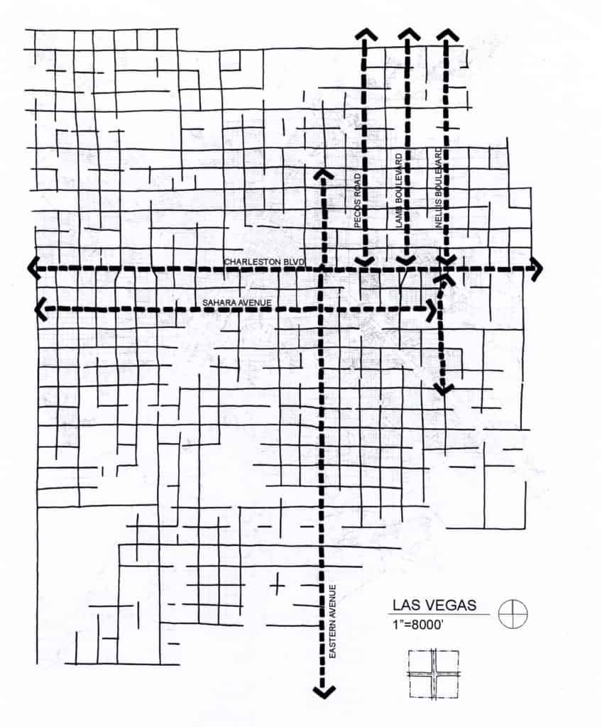
Urban form in Las Vegas has evolved over time to privilege the CBD/historic area so there is a micro-scale urban fabric that includes the historical diagonal routes from the CBD to the edges of the city in addition to this macro-scale orthogonal grid logic arising from the national grid system. We can demonstrate this by identifying all orthogonal routes aligned to cardinal directions arising from the pattern of land division. Some of these streets are long and highly connected (such as Charleston Boulevard). Others are not but all are evenly spaced apart in terms of metric distance arising from a historical process (subdivide the section, township, etc.) previously described by John Reps in The Making of Urban American/Cities of the American West. These streets represent the “strong prescriptive order” (using Pope’s terminology) of the national grid system as realized on the ground over time in the urban object. A portion of the ‘holistic’ Las Vegas super grid is composed of these large-scale orthogonal streets. This includes highly integrated routes such as Charleston Boulevard (east-west) and the southern segment of Las Vegas Boulevard (north-south).
Orthogonal Las Vegas: All orthogonal routes emerging from the pattern of land division imposed by the 1785 Land Ordinance.
However, this orthogonal logic is imperfectly realized. There are two reasons. First, the national grid system is a conceptual division of the land. The process Reps describes of section lines becoming main roads and so forth did not always occur for every tract of land. Second, the national grid system lays over the circumstance of the Earth. Bill Bryson succinctly summarizes the problem this causes for surveyors. “One problem with such a set-up is that a spherical planet does not lend itself to square corners. As you move near the poles, the closer the lines of longitude grow… (so) to get around this problem, longitudinal lines were adjusted every twenty-four miles… (which) explains why north-south streets… so often taken a mysterious jag” (136). This appears to be evident in diversions along the length of some north-south streets in Las Vegas. Peeling off this large-scale orthogonal street network reveals the underlying variation in the Las Vegas urban layout including a striking center-to-edge pattern formed by the historical diagonal routes and micro-scale street network. This shows how movement might utilize the urban grid, independently of the large-scale orthogonal streets.
Las Vegas’ Privileged Center: Center-to-edge urban pattern privileging the CBD/historic area.
The effect of the micro-scale street network is to privilege Las Vegas’ CBD/historical area. Configurational analysis using space syntax demonstrates this micro-scale street network is more closely related (significantly so) to the Las Vegas urban grid as a whole than the macro-scale network. This should be unsurprising. The crucial relationship for movement/urban functions in a city is center-to-edge. Edge-to-edge movement (for example, passing through Las Vegas in going from one city to another, i.e. Denver to Los Angeles) is nominally the function of the interstate highways. Instead, the macro-scale network operates as super-integrators since these streets are about six times more connected into the network compared to the average in Las Vegas.
The macro-scale network is reminiscent of a hierarchy imposed on the urban fabric by large-scale historic interventions: for example, Haussmann’s 19th century boulevards in Paris. However, there are key differences. First, the national grid system is an a priori conceptual order. Development allows this hierarchy to emerge during the growth of American cities. It is not a later remedial correction to the urban fabric. Second, it is distinct from the Las Vegas super grid. Some streets compose both but the most important are the diagonals of Las Vegas Boulevard, Main Street, Fremont Street, and Rancho Drive. If we removed the super grid in a similar experiment, then the urban fabric would disintegrate into discrete elements in the absence of these diagonals. Finally, there are highly segregated interstitial areas of the urban grid. These are suburban-type developments poorly connected into the urban grid except via the large-scale orthogonal streets defining their perimeters. We can describe this as discrete separation by linear segregation. Often, the only connection from neighborhood-to-neighborhood is via parallel curb cuts into separate developments (with at least one development somewhere having a minimum of two entry roads). This has nothing to do with inter-connectivity and everything to do with traffic management of vehicular turning actions.
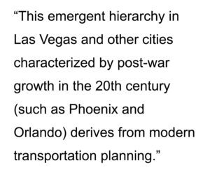
This emergent hierarchy in Las Vegas and other cities characterized by post-war growth in the 20th century (such as Phoenix and Orlando) derives from modern transportation planning. Regulatory requirements mandate the design of roads including street width, stopping distance, frequency of curb cuts, turning radius, and so on based on traffic speeds/volumes projected to utilize the streets using origin and destination gravity models Local governments have adopted these standards into their development review regulations, having a profound impact on American urban form since the mid-twentieth century. Planning to ‘minimum requirements’ gives rise to a spatial hierarchy that becomes embedded in the urban pattern. Borrowing from Christopher Alexander, Las Vegas proves that, in part, a city can be a tree. It is a different question whether it makes good urban form.
Based on excerpts from forthcoming The Syntax of City Space: American Urban Grids by Mark David Major.
“Come and keep your comrade warm, I’m back in the U.S.S.R. Hey you don’t know how lucky you are boys, Back in the U.S.S.R.” — Back in the U.S.S.R., The Beatles
Urban Patterns | Petropavlovsk-Kamchatsky, Russia by Dr. Mark David Major, AICP, CNU-A
NOTE: Urban Patterns is going to focus on more obscure and/or extreme locations in a number of posts over the next few weeks.
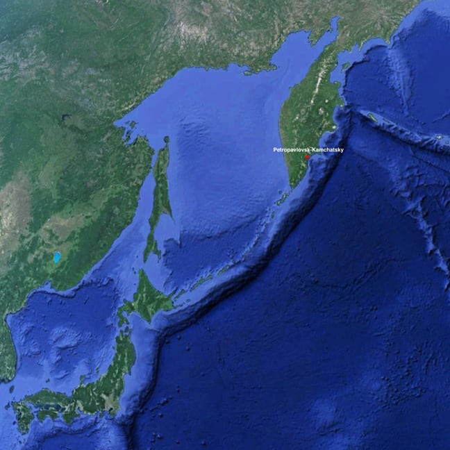
Satellite view from 3,000 km showing the location of Petropavlovsk-Kamchatsky, Russia north of Japan (Source: Google Earth).
Petropavlovsk-Kamchatsky is located on the Avacha Bay along the Pacific Coast of Russia on the Kamchatka Peninsula to the northeast of Japan. The city and peninsula are located several hundred miles to the west of an extent of the Mariana Trench in the Pacific Ocean (see above). The Mariana Trench is where the Pacific plate dives under the Asian plate on the Earth. Because of this, several hundred miles to the west are a series of volcanoes generated by plate tectonics, the most famous of which is probably Mount Fuji outside of Tokyo, Japan. Petropavlovsk-Kamchatsky has a population of more than 178,000 (the overwhelming majority of which are ethnic Russians and Ukrainians), which serves as the cultural and administrative center of the Kamchatka Krai (a krai is an administrative division of the Russian Empire). In fact, more people live in the city than in the entirety of the peninsula. However, the city’s population has declined by almost 100,000 people over the last 20 years. Russia’s (and the former Soviet Union) largest submarine base is located on Avacha Bay across from Petropavlovsk-Kamchatsky. The city was founded by Danish navigator Vitus Bering in the service of the Russian Navy in 1740.
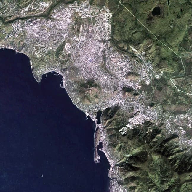
Satellite view from 15 km of Petropavlovsk-Kamchatsky, Russia (Source: Google Earth 2013).
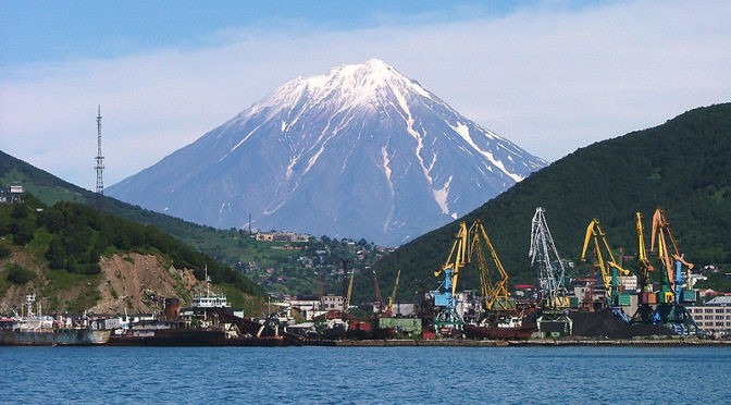
He named the new settlement “Petropavlovsk” (Peter and Paul) after his two ships, the St. Peter and the St. Paul. In addition to serving as an administrative center and providing infrastructure support for the Russian Navy, Petropavlovsk-Kamchatsky’s main commercial industry is fishing, salmon and crab meat in particular. Petropavlovsk-Kamchatsky is characterized by a subarctic climate and about three-and-a-half times more snow falls in this area compared to Siberia though, due to its location, temperatures are much milder year-round. Due to plate tectonics, Petropavlovsk-Kamchatsky is surrounded by high hill and volcanoes; see the header image of Petropavlovsk and Koryaksky Volcano, as seen from Avacha Bay (Source: Wikipedia).
Because of this, the urban grid in the city is characterized by two attributes: first, a large extent of roads throughout the city and along the coast curving in relation to elevation changes in the area, as seen in other hilly cities around the world, which Moholy-Nagy referred to as a “geomorphic” pattern; and second, the deformation of a series of small-scale regular grids to optimize the buildable area on the flatter terrain, particularly inland to the northeast of the original town. The oldest part of the city is located directly on the bay, east of the smaller peninsula extended and made somewhat more ‘regular’ in shape by the intervention of man over the previous 250 years, i.e. at the lower center of the above image.
(Updated: July 2, 2017)
Urban Patterns is a series of posts from The Outlaw Urbanist presenting interesting examples of terrestrial patterns shaped by human intervention in the urban landscape over time.
Share the knowledge!
Blogging about architecture, urbanism, and culture…

 We cannot skate our way to spatial freedom but only walk the path of its responsibilities.
 Cooke implies waitresses were serving pizza sans clothing but it could have meant the roadside lunch counter was serving its pizza lunch sans toppings, i.e. Margherita. Given Las Vegas’ reputation, it is probably wise to assume both options were on the menu. In any case, architects and urban planners have shared this fascination with the ‘Modern Babylon’ of Western civilization.
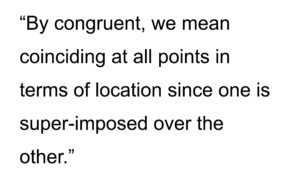 The a priori conditions are a consequence of the pattern of land division imposed by the 1785 Land Ordinance. Using computer modeling such as the configurational software of space syntax, we can ‘peel’ these congruent spatial systems apart and examine their role in Las Vegas; much like peeling layers off an onion and examining the individual layers (we know together they form an onion). The results are fascinating. First, Las Vegas has a well-defined, center-to-edge spatial pattern, the focus of which is not the Las Vegas Strip (though it is partially in the core) but the historic area/Central Business District (CBD). Second, a congruent, large-scale orthogonal spatial pattern emerging from the pattern of land division over time characterizes Las Vegas. This orthogonal grid pattern did not exist in the early 20th century (though we can infer its outline from section lines) and only began to emerge during the 1950s and 1960s before fully manifesting in the late 20th century.
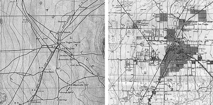
 cuts into separate developments (with at least one development somewhere having a minimum of two entry roads). This has nothing to do with inter-connectivity and everything to do with traffic management of vehicular turning actions.