Tag Archives: Planning

Urban Patterns | Kansas City, Missouri-Kansas USA

“We’ll be standin’ on the corner of 12th in line
With our Kansas City baby and our bottle of Kansas City wine.”
Kansas City, Little Richard

Urban Patterns | Kansas City, Missouri-Kansas USA
by Dr. Mark David Major, AICP, CNU-A

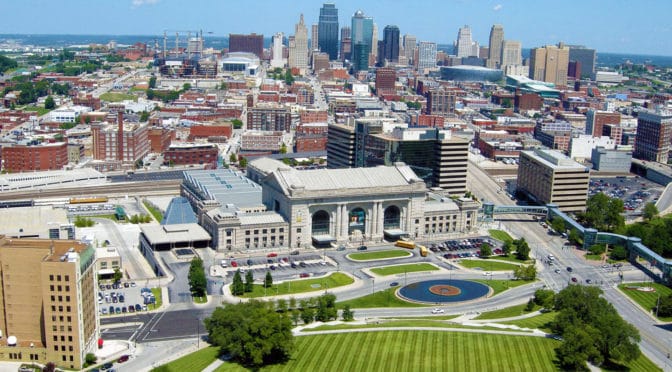
Kansas City, Missouri is the largest city in the state and the sixth largest city in the American Midwest. According to the U.S. Census Bureau, the city had an estimated population of 481,420 in 2016, making it the 37th largest city by population in the United States. It is the anchor city of the Kansas City metropolitan area, which straddles the Kansas–Missouri border. Kansas City was founded in the 1830s as a Missouri River port at its confluence with the Kansas River. On June 1, 1850, the town of Kansas was incorporated; shortly after came the establishment of the Kansas Territory. Confusion between the two ensued and the name Kansas City was assigned to distinguish them soon thereafter. Kansas City, Kansas is the third-largest city in that state and the third-largest city (after Kansas City, Missouri and Overland Park, Kansas) of the Kansas City metropolitan area. The Kansas City metropolitan area is a 15-county metropolitan area that straddles the border between Missouri and Kansas. With a population of about 2,340,000, it ranks as the second largest metropolitan area in Missouri (after Greater St. Louis). Kansas City, Kansas is abbreviated as KCK to differentiate it from Kansas City, Missouri. As of the 2010 census, Kansas City, Kansas had a population of 145,786 residents. (Source: Wikipedia).

Satellite view, 15 km, Kansas City,Missouri-Kansas USA, Google Earth
Satellite view from 15 km of Kansas City Missouri-Kansas USA (Source: Google Earth).

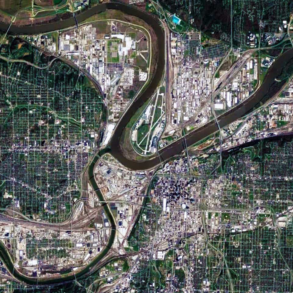
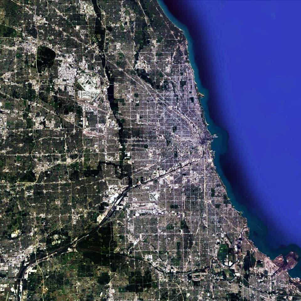
There are two distinctive characteristics to the urban pattern of Kansas City at different scales of the city. The first is the series of large building footprints and urban blocks composing a series of small-scale (in relative terms) offset grids adjacent to the Missouri and Kansas Rivers. This is most apparent in the close-up satellite view from 15 km of Kansas City (see above). This is a direct result of its historical origins in water transportation, which remains important to this day for the city; namely, the laying out of street networks to ensure a rectangular shape to the plots on the most valuable land immediately adjacent to the rivers.

Satellite view, 30 km, Kansas City,Missouri-Kansas USA, Google Earth
Satellite view from 30 km of Kansas City Missouri-Kansas USA (Source: Google Earth).

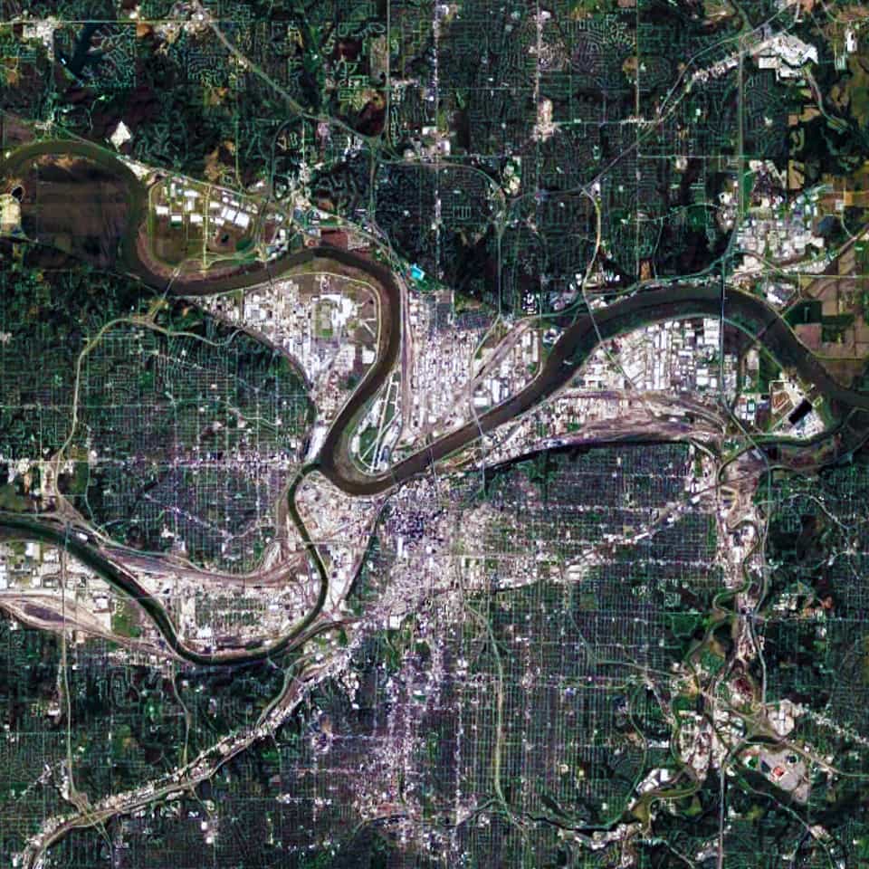
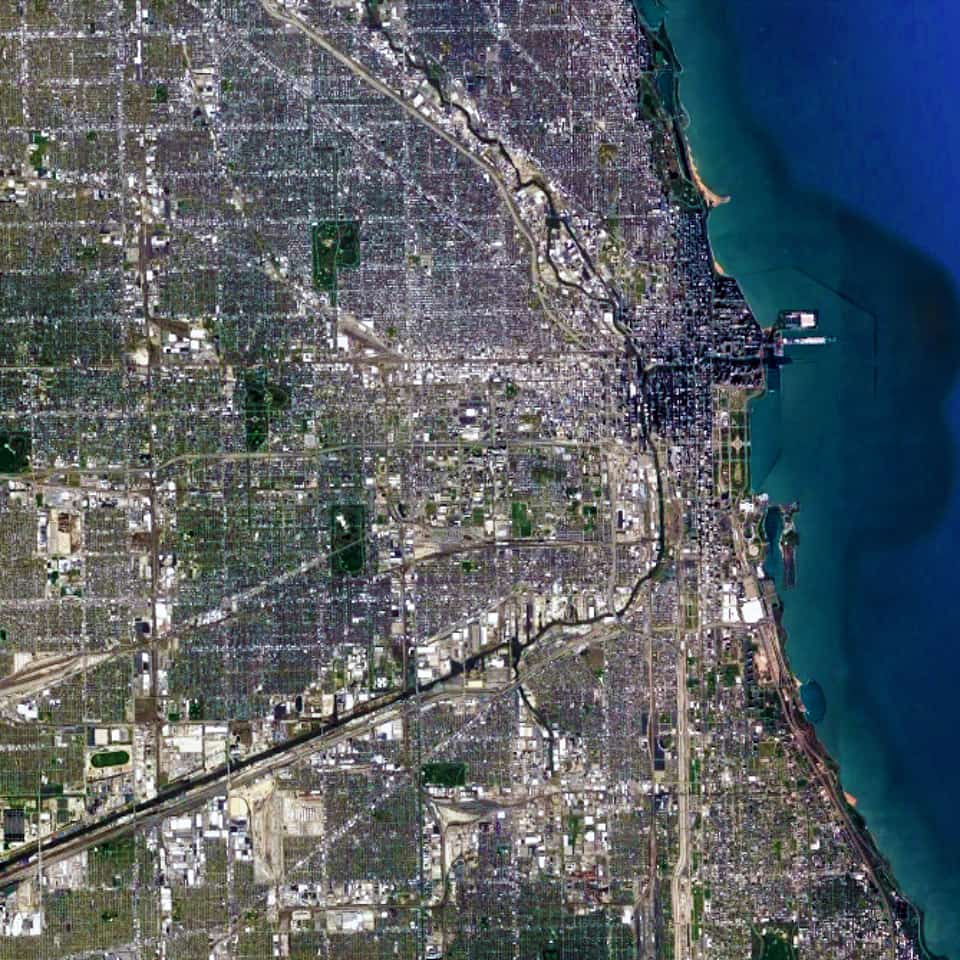
When examining the Kansas City urban pattern at the large-scale (see satellite view from 30 km above), the second distinctive characteristic becomes much more apparent; namely, a strong north-south and east-west structure in the street network of Kansas City. Initially, some people might think this occurred due to the stereotypical view about the ‘flatness’ of the American prairie. However, the topography in and around Kansas City is composed of gentle, rolling hills and river bluffs. Instead, this is evidence of the emergent pattern of the Jeffersonian grid in the 1785 Land Ordinance.

Urban Patterns is a series of posts from The Outlaw Urbanist presenting interesting examples of terrestrial patterns shaped by human intervention in the urban landscape over time.

Share the knowledge!
Share

Planning Naked | Cessation of a Feature

Planning Naked | Cessation of a Feature
by Dr. Mark David Major, AICP, CNU-A

For two-and-a-half years now, The Outlaw Urbanist has brought you a semi-regular feature as regular as we can manage in the best interests of our mental health called “Planning Naked.” It has been your (hopefully hilarious) guide to most everything about the latest issue of APA’s Planning Magazine.

Due to changing circumstances, we are announcing a cessation of the “Planning Naked” feature. Somehow, we think the editors and reporters of Planning Magazine will be relieved to hear this news.

However, The Outlaw Urbanist is open to this cessation being of temporary nature, if there are any readers who would like to take up the mantle of fighting the status quo and helping to police the underlying  often hidden assumptions of the editors and reporters of APA’s Planning Magazine by volunteering to write new editions of “Planning Naked.”

If you are interested, email us at [email protected].

Planning Naked has been a semi-regular feature article with observations and comments about a recent issue of Planning: The Magazine of the American Planning Association.

Share the knowledge!
Share

Urban Patterns | Doha, Qatar

“Ya’ know that, this town’s like a painted desert
Dead heat, movin’ in the city, I’m lost in a painted desert.”
— Painted Desert, Pat Benatar

Urban Patterns | Doha, Qatar
by Dr. Mark David Major, AICP, CNU-A

Doha (Arabic: الدوحة‎‎, ad-Dawḥa or ad-Dōḥa) literally meaning “the big tree” but, locally, “rounded bays” is the capital city and most populous city in the State of Qatar. Doha has a population of 1,351,000 in the city proper with a metropolitan population close to 1.5 million. The city is located on the coast of the Persian Gulf in the east of the country. It is Qatar’s fastest growing city with over 50% of the nation’s population living in Doha or its surrounding suburbs. It is the economic center of the country. Doha was founded in the 1820s as an offshoot of Al Bidda. It was officially declared as the country’s capital in 1971 when Qatar gained independence from being a British Protectorate. As the commercial capital of Qatar and one of the emergent financial centers in the Middle East, Doha is considered a world city by the Globalization and World Cities Research Network. The city of Doha was formed after seceding from another local settlement known as Al Bidda. The earliest documented mention of Al Bidda was made in 1681 by the Carmelite Convent in an account, which chronicles several settlements in Qatar. In the record, the ruler and a fort in the confines of Al Bidda are alluded to. Carsten Niebuhr, a European explorer who visited the Arabian Peninsula, created one of the first maps to depict the settlement in 1765 in which he labeled it as ‘Guttur’ (Source: Wikipedia).

1947, Aerial, photograph, Doha, Qatar, UCL Qatar
1947 Aerial photograph of Doha, Qatar (Source: UCL Qatar).

Recently, UCL Qatar created a new interactive map to explore the history of Doha from the late 1940s to the present day here. The Origins of Doha is a UCL Qatar research project, supported by the Qatar National Research Fund, which aims to explore the foundation and historic growth of Doha, its transformation to a modern city, and the lives and experiences of its people through a combination of archaeological investigation, historical research, and oral testimony (Source: UCL Qatar).

What we see in this 1947 aerial photograph (see above) is a very compact settlement gathered along the shoreline of the Doha Port on the Persian Gulf. The settlement is so compact that it is difficult to discern its spatial structure. However, if you focus on the center of the image, then look slightly southwards and eastwards, you can see a clear ring of circulation around a large block possessing an intricate street network. From this ring of circulation, we can discern at least four (4) diagonal streets radiating outwards in all directions. Given the rapid growth in Doha over the last 30 years, it is extremely difficult to assign modern day names to these places but it appears, more or less, consistent with the modern ‘downtown’ area. The older town of Al Bidda appears to be eastward of this area.

Satellite view, 15 km, Doha, Qatar, Google Earth
Satellite view from 15 km of Doha, Qatar (Source: Google Earth).

If we examine the urban pattern of Doha at the large scale (see the satellite view from 15 km above), then there is a distinctive ‘deformed wheel’ structure of diagonal streets radiating outward in most directions from the port. This network is connected together by a series of orbital roads, which encircle the city based on an increasing radii, as measured from the shoreline of the port. At this scale, the Doha urban pattern appears to be composed of massive ‘super blocks.’ However, this is misleading. The network of publicly-accessible space is more intricate than this, indicating an attempt to somewhat separate large-scale vehicular traffic from more localized types of traffic in these ‘super blocks.’

Satellite view, 2 km, super block, neighborhood, Doha, Qatar, Google Earth
Satellite view from 2 km of a ‘super block’ neighborhood in Doha, Qatar (Source: Google Earth).

This is more apparent if we zoom on one of these ‘super blocks’ (see the satellite view from 2 km above). We can discern the prototypical pattern you might in some older Middle Eastern settlements with narrower streets and a marginal offsetting of blocks, designed to subtly deter through traffic in the area. Functionally, this is more akin to Olmsted’s efforts to do the same in the Riverside suburb of Chicago, though representing a much different geometrical strategy. In fact, this is more practical than the modern suburbia model of massive blocks of nebulous shape and minimal street connections, which you will find in many post-war suburbs of the United States, especially those constructed over the last 40 years. It seems likely these attempts to retain a traditional type of urban pattern while still accommodating the requirements of a modern vehicular traffic system has resulted in a tension in the urban street network, especially due to the rapid growth during the early 21st century.

Urban Patterns is a series of posts from The Outlaw Urbanist presenting interesting examples of terrestrial patterns shaped by human intervention in the urban landscape over time.

Share the knowledge!
Share

Urban Patterns | Chicago, Illinois USA

“Come on, babe, Why don’t we paint the town? And all that jazz.
I’m gonna rouge my knees, And roll my stockings down,
And all that jazz.
Start the car, I know a whoopee spot, Where the gin is cold,
But the piano’s hot! It’s just a noisy hall, Where there’s a nightly brawl,
And all that jazz.”

— Bob Fosse’s Chicago: The Musical

Urban Patterns | Chicago, Illinois USA
by Dr. Mark David Major, AICP, CNU-A

Chicago is the third-most populous city in the United States with over 2.7 million residents. It is also the most populous city in both the state of Illinois and the Midwestern United States. It is the county seat of Cook County. The Chicago metropolitan area often referred to as “Chicagoland” has nearly 10 million people. It is the third-largest metropolis in the United States (after New York and Los Angeles). In terms of wealth and economy, Chicago is considered one of the most important business centers in the world. The town of Chicago was organized in 1833 with a population of about 200 people near a portage between the Great Lakes and the Mississippi River watershed. Within seven years it grew to more than 4,000 people. In mid-1835, the first public land sales began. The City of Chicago was incorporated in 1837. For several decades, Chicago was the fastest growing city in the world. Chicago was one of the five largest cities in the world by 1900. Before the growth of new Chinese cities during the early 21st century, the urban growth of Chicago during the 19th century was largely unprecedented in human history (Source: Wikipedia and The Syntax of City Space: American Urban Grids).

Satellite view, 90km, Metropolitan Chicago, Illinois, USA, Google Earth
Satellite view from 90km of Metropolitan Chicago, Illinois in the USA (Source: Google Earth).

Chicago has the most pervasively-realized regular grid in the world. In fact, the scale of the regular grid in Chicago is so massive that it is almost impossible to truly appreciate its scale. From one extreme to the other, it is probably the size of southeast England or twice the size of the European country of Luxembourg. However, it is only by examining the Chicago urban pattern at this scale that we can truly appreciate that there is a distinctive center-to-edge logic to the metropolitan region; most notably along the alignment of the Chicago River/Stevenson Expressway from the Loop in a southwest direction out of the area. This center-to-edge logic is replicated at the large-scale in the northern metropolitan region as well along the alignment of old Indian trails, which were incorporated into the urban fabric as paved roads; most notably a series of diagonal streets associated with the Northwest Highway out of town towards the state of Wisconsin.

Satellite view, 25 km, Chicago, Illinois, USA, Google Earth
Satellite view from 25 km of Chicago, Illinois in the USA (Source: Google Earth).

When we zoom in on the Chicago urban pattern, the crucial role of the Chicago River as a water-based transportation artery in the city becomes much more obvious. So does the multitude of skyscrapers in the central business district of the Loop (north and west of Grant Park at the shoreline of Lake Michigan). We can also see the large building footprints of Industrial land uses gathered around the entire length of the Chicago River from the southeast into the center of the city and then northward. All of these topographical, geographical, and infrastructure components are woven together within the ‘relentless’ regular gridiron layout, which serves to privilege downtown Chicago (and, in particular, The Loop) within the larger urban pattern of metropolitan Chicago. This barely begins to scratch the surface of why the Chicago grid plays such a significant role in its magnificence as one of the world’s greatest urban patterns.

Urban Patterns is a series of posts from The Outlaw Urbanist presenting interesting examples of terrestrial patterns shaped by human intervention in the urban landscape over time.

Share the knowledge!
Share

AVAILABLE NOW | The Syntax of City Space

The Syntax of City Space: American Urban Grids by Mark David Major with Foreword by Ruth Conroy Dalton (co-editor of Take One Building) is now available for pre-order from Routledge, Amazon, and other online retailers. Routledge/Taylor & Francis Group will release The Syntax of City Space: American Urban Grids in November 2017.

Cover, The Syntax of City Space, American Urban Grids, Mark David Major, Ruth Conroy DaltonMany people see American cities as a radical departure in the history of town planning because of their planned nature based on the geometrical division of the land. However, other cities of the world also began as planned towns with geometric layouts so American cities are not unique. Why did the regular grid come to so pervasively characterize American urbanism? Are American cities really so different?

The Syntax of City Space: American Urban Grids by Mark David Major with Foreword by Ruth Conroy Dalton (co-editor of Take One Building) answers these questions and much more by exploring the urban morphology of American cities. It argues American cities do represent a radical departure in the history of town planning while, simultaneously, still being subject to the same processes linking the urban network and function found in other types of cities around the world. 
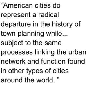
A historical preference for regularity in town planning had a profound influence on American urbanism, which endures to this day.

Download the Routledge/Taylor & Francis Group European promotional flyer here.

The Syntax of City Space: American Urban Grids is available for pre-order purchase with Routledge/Taylor & Francis Group, Amazon, Waterstones, and Foyles in the UK as well as other online retailers around the world.

Visit our Books for Sale page here.

About the Author
Dr. Mark David Major, AICP, CNU-A is an Assistant Professor of Architecture and Urban Design at Qatar University in Doha, Qatar. He is a graduate of Clemson University, University College London, and the University of London.

The Syntax of City Space: American Urban Grids
by Mark David Major with Foreword by Ruth Conroy Dalton
Hardcover, English, 260 pages
Routledge, First Edition (November 2017)
ISBN-10: 1138301566
ISBN-13: 978-1138301566

Purchase from Routledge/Taylor & Francis here.
Purchase from Amazon here.
Purchase from Waterstones here.
Purchase from Foyles here.

Share the knowledge!
Share