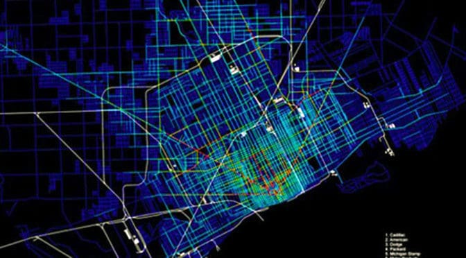
Featured Image: Choice network analysis at radius 10,000 meters of Detroit in 1952 with industry superimposed from Paradigm lost, Industrial and post-industrial Detroit (Psarra et al, 2013).
REVIEW: Paradigm lost, Industrial and post-industrial Detroit by Sophia Psarra, Conrad Kickert, and Amanda Pluviano, Urban Design International, Advanced Online Publication, March 27, 2013
by Mark David Major, The Outlaw Urbanist contributor
There is a simple question at the heart of the Psarra et al paper, “Paradigm lost: Industrial and post-industrial Detroit – An analysis of the street network and its social and economic dimensions from 1796 to the present,” available as an advanced online publication from Urban Design International. This question is: can spatial pattern be implicated in the remarkable urban decline of Detroit over the last half-century? It is an important question precisely because so many architecture, urban design and planning professionals – as well as politicians and policy makers – never bother to ask it, especially in the United States. The answer provided by Psarra et al is an academically careful and qualified ‘yes’.
Their basic argument is the locating of large-scale industrial uses at the northern periphery of the urban grid (along and near to Davison St./Grand Ave.) beginning around 1900-1910 – in combination with interstate highway system construction and decline of the streetcar system a few decades later – served to disrupt the integrated functioning of the urban street network, commercial, industrial and residential land uses, and the transportation infrastructure serving them (railroads, streetcars) in the city. This facilitated radical decentralization of Detroit to the suburbs, where developers and industry could find ever larger and cheaper land parcels. Their argument is a little more nuanced than this but that is the gist. In doing so, they conclude (though don’t say so bluntly) the automobile both made and destroyed Detroit.
They acknowledge more complex factors were, no doubt, at work in the decline of Detroit but argue understanding the pattern of urban space and how it relates to land uses and transportation infrastructure is crucial for diagnosing the problem. In its diagnosis, the paper excels though it is very light on offering solutions (beyond a vague call for “radical solutions”).  For example, they generally discuss what they describe as “Landscape Urbanism” without much detail. They are far too kind to reveal what, I suspect, is probably an outright disdain for this approach to serious urban problems. Landscape Urbanism only exists because it is politically expedient and offers policy makers/politicians the appearance of doing something (and feeds the financial coffers of consultants) when, in fact, it is usually a useless solution that avoids the real problem all together. What is really interesting about their historical analysis is where industrial land uses were not located; namely, along the riverfront at the edge of the Woodward plan. This suggests the seeds of Detroit’s urban decline might be traced back to the early 19th century. Large-scale industrial land uses may not have been allowed to develop along the riverfront of the Woodward plan. If the industrial land uses along Davison/Grand had come to be located along the riverfront instead of the northern periphery, Detroit may have been better positioned to manage its transition from an industrial to a post-industrial city, as other cities have accomplished to varying degrees of success.
By necessity, academic articles cannot cover all of the bases. For example, I would have liked to have seen spatial analysis of contemporary Detroit with its interstate highway system ‘peeled off’ to better reveal its disruptive effect on the underlying street grid pattern. I’m not even sure if current space syntax software allows for this kind of ‘alternative’ analysis. I would have also liked to have seen a spatial model of Detroit embedded within its larger urban context to the south in Canada (Windsor/LaSalle), where the railroad lines do terminate along the riverfront of the Detroit River. There is also the political factor. Detroit has been subject to one-party rule (Democratic) for the last half-century and it’s hard to believe this is only coincidental with its decline as an urban center. To excuse the Democratic Party from Detroit’s decline, one almost has to concede that all government policies are essentially useless (a very Libertarian position). However, there is only so much anyone can cover in an article. “Paradigm lost, Industrial and post-industrial Detroit” is well worth the read. At the very least, it will get you questioning the “conventional wisdom” in the field about Detroit and other cities experiencing similar problems.
You read the full article online or download a PDF via the link below:
URBAN DESIGN International | Paradigm lost: Industrial and post-industrial Detroit – An analysis of the street network and its social and economic dimensions from 1796 to the present.
 The course covers the financial, institutional, and legal hurdles/pitfalls confronting space syntax in the American market, especially in the private sector. Using a series of ‘back-of-the-napkin’ financial calculations common to the American development process, the course demonstrates how these challenges can transform into a distinct advantage for advocating the cause of the space syntax in the United States. The course concludes by discussing the enormous challenges and opportunities for space syntax in America today (1.0 hour course).


 For example, they generally discuss what they describe as “Landscape Urbanism” without much detail. They are far too kind to reveal what, I suspect, is probably an outright disdain for this approach to serious urban problems. Landscape Urbanism only exists because it is politically expedient and offers policy makers/politicians the appearance of doing something (and feeds the financial coffers of consultants) when, in fact, it is usually a useless solution that avoids the real problem all together. What is really interesting about their historical analysis is where industrial land uses were not located; namely, along the riverfront at the edge of the Woodward plan. This suggests the seeds of Detroit’s urban decline might be traced back to the early 19th century. Large-scale industrial land uses may not have been allowed to develop along the riverfront of the Woodward plan. If the industrial land uses along Davison/Grand had come to be located along the riverfront instead of the northern periphery, Detroit may have been better positioned to manage its transition from an industrial to a post-industrial city, as other cities have accomplished to varying degrees of success.