Tag Archives: The Urban Pattern

Urban Patterns | London, United Kingdom

“London calling, yes I was there too,
An’ you know what they said well some of it was true!”
London Calling, The Clash

Urban Patterns | London, United Kingdom
by Dr. Mark David Major, AICP, CNU-A

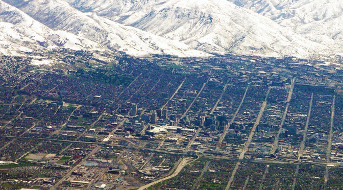
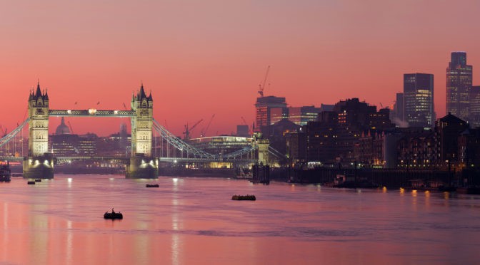
London is the capital and most populous city of England and the United Kingdom. Standing on the River Thames in the southeast of the island of Great Britain, London has been a major settlement for two millennia. It was founded by the Romans, who named it Londinium. London’s ancient core, the City of London, largely retains its +square-mile medieval boundaries. Since at least the 19th century, “London” has also referred to the metropolis around this core, historically split between Middlesex, Essex, Surrey, Kent, and Hertfordshire, which today largely makes up Greater London, governed by the Mayor of London and the London Assembly. London is a leading global city in the arts, commerce, education, entertainment, fashion, finance, healthcare, media, professional services, research and development, tourism, and transportation. London has a diverse range of people and cultures, and more than 300 languages are spoken in the region. The estimated mid-2015 municipal population (corresponding to Greater London) was 8,673,713, which is the largest of any city in the European Union, and accounting for 12.5% of the UK population (Source: Wikipedia).

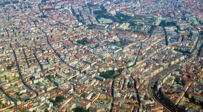
Archaeological discoveries in the London area have found evidence of structures that date back as far as 4,500 B.C., indicating humans have occupied the area far longer than previously thought. However, the founding of London by the Romans in 43 AD still marks the first large-scale settlement in the area. This settlement was founded in the location of the modern “Square Mile” of the City of London (to the right of the below satellite view, north of the River Thames where there are five bridges).

1572 Braun & Hogenberg’s 1572 map of London showing the City of London (center) and the early origins of the City of Westminster (far left) and the Bankside area (bottom center, south of the River Thames).

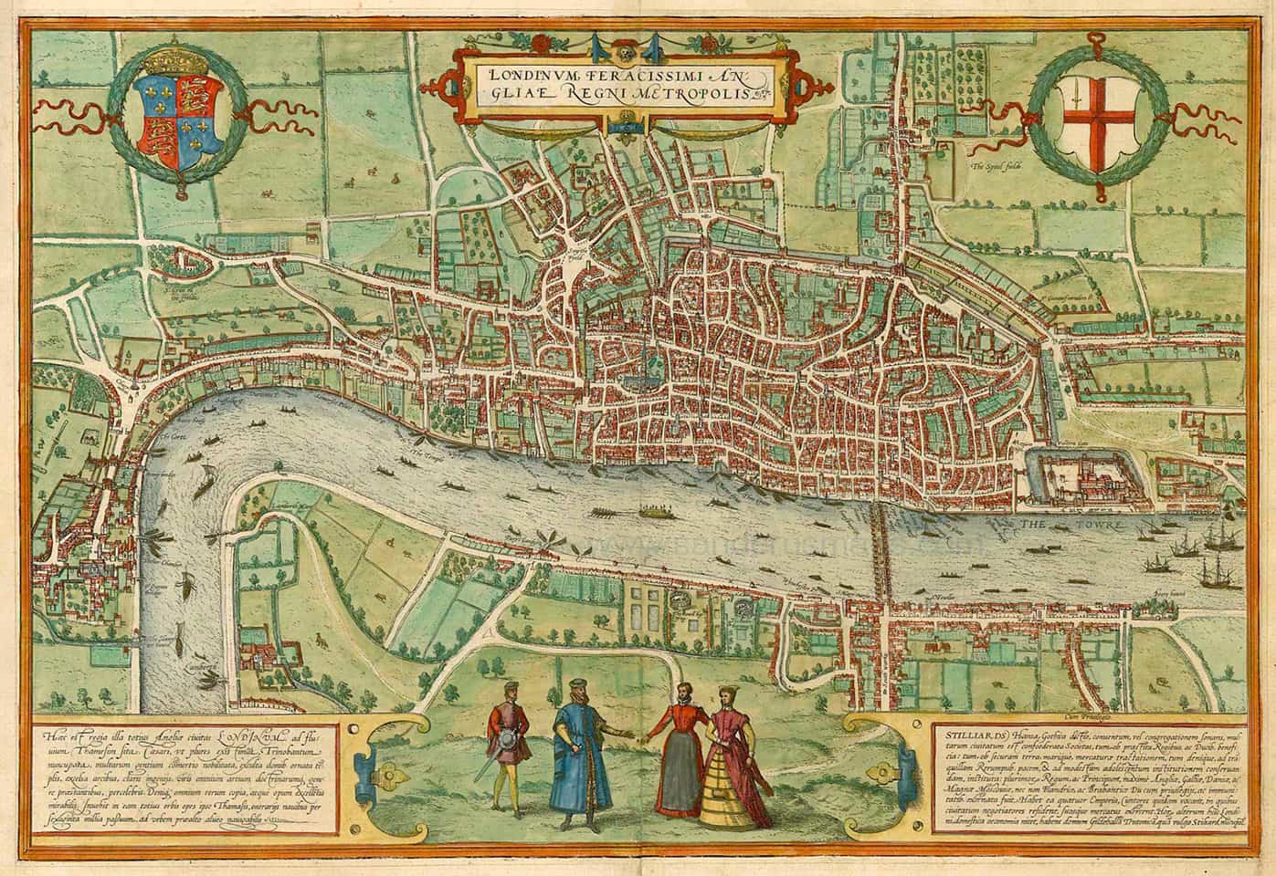
The City of Westminister (west and south of St. James Park along the River Thames where it has a – more or less – north-south alignment at this location) predates the Norman Conquest of England in 1066. The two distinct settlements only began to merge together during the 16th century (see above).

Satellite view of central London from 15 km (Source: Google Earth).

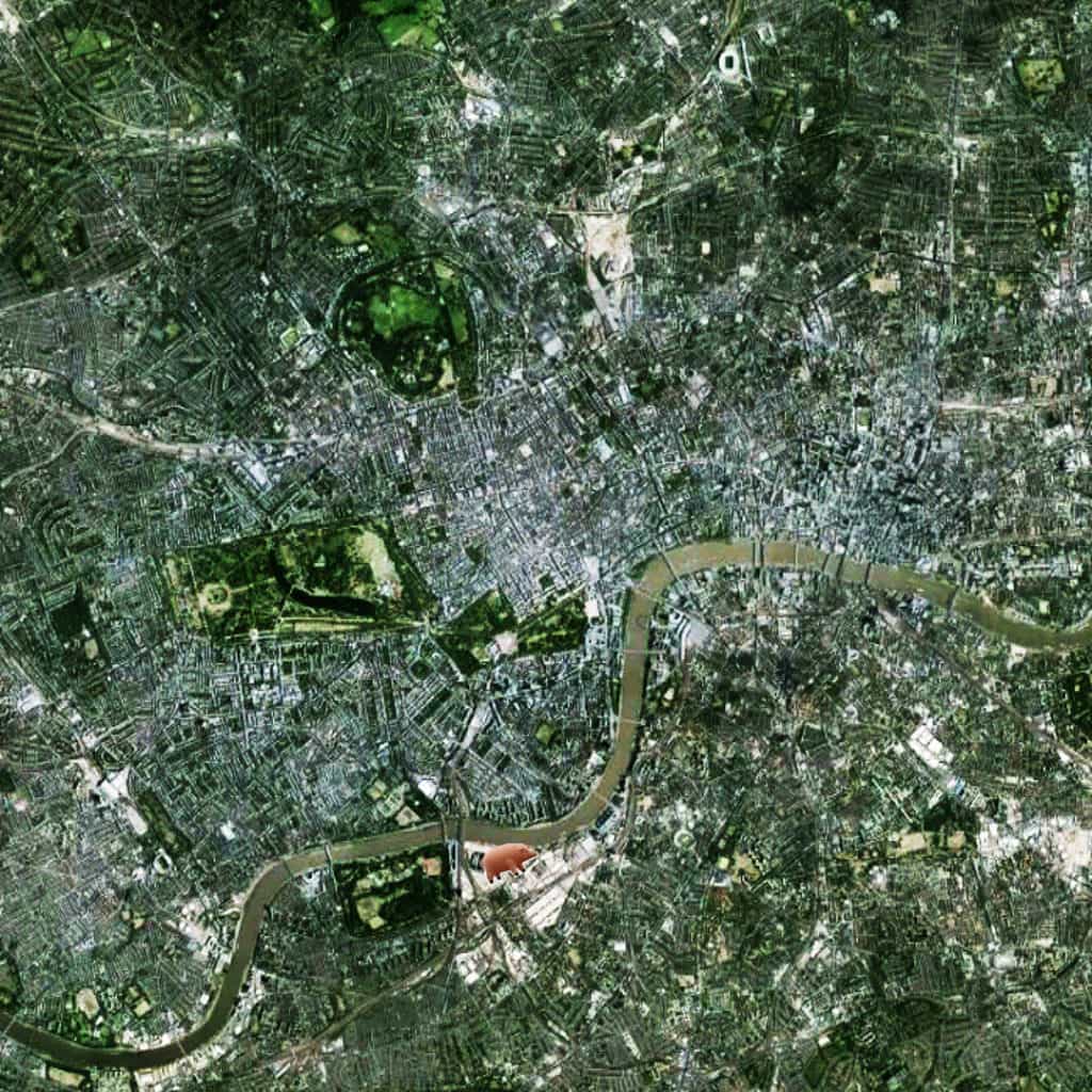
This created a new urban focus in what is now called the West End (the exact center of this image, which is focused on Piccadilly Circus, adjacent to Hyde Park) and, specifically, Oxford Street (the clearly visible, long east-west street at the center of the image). The City of London is characterized by a small-scale, deformed grid pattern of small blocks and short streets (in relative terms, though not nearly as small-scale as during the Medieval period).

Pink Floyd’s Animals album cover illustration of a pig flying over Battersea Power Station.

In fact, all of London has a deformed grid pattern radiating outward from center-to-edge whereby the scale of the grid became larger for street lengths and block sizes (such as in the West End) during the growth of the city in order to mediate the relationship between the center and its ever-expanding edges.

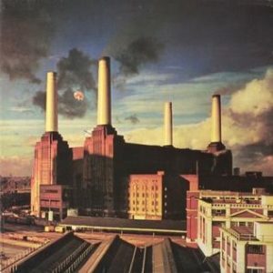
NOTE: As any Pink Floyd fan might expect, the flying pig marks the location of Battersea Power Station, currently and finally being redeveloped.

(Updated: June 16, 2017)

Urban Patterns is a series of posts from The Outlaw Urbanist presenting interesting examples of terrestrial patterns shaped by human intervention in the urban landscape over time.

Share the knowledge!
Share

Urban Patterns | New York, New York USA

“Even old New York was once New Amsterdam,
Why they changed it, I can’t say,
People just liked it better that way.”
Istanbul (Not Constantinople), They Might Be Giants (BTW, now in San Francisco)

Maybe you were expecting this…

“These vagabond shoes are longing to stray,
Right through the very heart of it: New York, New York.”
New York, New York, Frank Sinatra

Urban Patterns | New York, New York USA
by Dr. Mark David Major, AICP, CNU-A

New York is the most populous city in the United States. With an estimated 2016 population of 8,537,673 distributed over a land area of about 302.6 square miles (784 km2), New York City is also the most densely populated major city in the United States. Located at the southern tip of the state of New York, the city is the center of the New York metropolitan area, one of the most populous urban agglomerations in the world. New York City exerts a significant impact upon commerce, finance, media, art, fashion, research, technology, education, and entertainment around the world; its fast pace defining the term “a New York minute.” Home to the headquarters of the United Nations, New York is an important center for international diplomacy and has been described as the cultural, financial, and media capital of the world. Dutch merchants and settlers originally founded New York (originally named New Amsterdam) – along with three other Dutch forts in present-day New York State – on Manhattan Island at the conflux of the Hudson and East Rivers into a natural harbor at Upper New York Bay in 1625. As evidenced in the Castello Plan (see below), the early settlement was composed of small-scale offset regular-ish grids oriented to the shoreline of the Hudson and East Rivers at the southern tip of Manhattan Island (Source: Wikipedia).

Redraft of the Castello Plan of New Amsterdam in 1660, redrawn in 1916 by John Wolcott Adams and Isaac Newton Phelps Stokes (Source: Wikipedia).

Over the first 100 years of the settlement, this geometric layout (in the modern Wall Street area) evolved into a classic, European deformed grid pattern. In planning terms, Manhattan is probably best known for the 1811 Commissioners Plan (see here for more information), which imposed a gridiron over most of the island north of the Wall Street area.

1789 Plan of New York, New York USA (Source: University of Texas).

However, as evidenced by historic plans of New York such as the 1789 plan of southern Manhattan (see above), this gridiron was really an extension of an already-existing regular grid immediately north of that area, predating the Commissioners Plan by two decades.

Satellite view from 20 km of New York, New York USA (Source: Google Earth).

The overall linear (more or less, south to north) shape of the island was well-suited for regular grid extension, especially in the middle portion of the island around Central Park. At 843 acres, Central Park (designed by landscape architect Frederick Law Olmsted and the English architect Calvert Vaux) is still one of the largest urban parks in the world and the most visited park in the United States. Architects and planners often discuss the planning of Manhattan to the exclusion of its larger urban context (especially in discussing the 1811 Commissioners Plan). However, the island is well-embedded within its larger urban context, possessing some 19 bridge and tunnel connections to the surrounding area, especially to the north of the island where 12 (63%) of these connections are available.

(Updated: August 14, 2017)

Urban Patterns is a series of posts from The Outlaw Urbanist presenting interesting examples of terrestrial patterns shaped by human intervention in the urban landscape over time.

Share the knowledge!
Share

Urban Patterns | Vienna, Austria

“Now in Vienna there are ten pretty women,
There’s a shoulder where Death comes to cry.”
Take this Waltz, Leonard Cohen

Urban Patterns | Vienna, Austria
by Dr. Mark David Major, AICP, CNU-A

Vienna is the capital and largest city of Austria with a population of about 1.8 million (2.6 million within the metropolitan area, nearly one-third of Austria’s population), and its cultural, economic, and political center. It is the 7th-largest city by population within city limits in the European Union. There is evidence of continuous habitation in Vienna since 500 BC when the site on the Danube River was first settled by the Celts. In 15 BC, the Romans fortified the frontier city they called “Vindobona” to guard the empire against Germanic tribes invading from the north. Vienna is known for its high quality of life. In a 2005 study of 127 world cities, the Economist Intelligence Unit ranked the city first (in a tie with Vancouver, Canada and San Francisco, USA) for the world’s most liveable cities (Source: Wikipedia).

Satellite view from 5 km of Vienna, Austria (Source: Google Earth).

The urban layout of Vienna is a classic European deformed grid with a series of open-angled diagonal routes radiating outward from center-to-edge and intersecting/overlaying with a series of ring/orbital roads, which similarly radiate outwards based on an increasing radius from center-to-edge, i.e. smaller rings in the center, successively larger in the periphery. As in other European cities, the deformed grid pattern in the oldest area of the city (more or less center above) is composed of smaller blocks and shorter streets. As the city has grown in size, the size of blocks and length of streets (and associated segments) have increased, which embeds the layout with a strongly consistent geometric logic (especially when blocks are examined in discrete terms) in its deformed grid pattern.

(Updated:  May 18, 2017)

Urban Patterns is a series of posts from The Outlaw Urbanist presenting interesting examples of terrestrial patterns shaped by human intervention in the urban landscape over time.

Share the knowledge!
Share

Urban Patterns | Las Vegas, Nevada USA

“I wanna feel sunlight on my face. I see the dust-cloud,
Disappear without a trace. I wanna take shelter,
From the poison rain, Where the streets have no name.”
Where the Streets Have No Name, U2

Urban Patterns | Las Vegas, Nevada USA
by Dr. Mark David Major, AICP, CNU-A

There is a lot that can be said – and has been said over the years – about the “Modern Babylon’ known as Las Vegas, Nevada. Las Vegas comes from the Spanish, who used artesian wells for water in the area, supporting green meadows (vegas in Spanish), on journeys along the Old Spanish Trail from Texas during the 19th century. Mormons were the first to settle in the area in 1855 when Brigham Young assigned missionaries from Salt Lake City to convert the local Indian population to Mormonism. They constructed a fort near the current downtown area, which served as a stopover for travelers between Salt Lake City and Los Angeles. The missionaries abandoned the settlement a couple of years later during the Utah War (a bloodless confrontation between Mormon settlers and the U.S. Government).

Las Vegas, Nevada in 1906 (Source: Las Vegas Convention and Visitors Authority).

Las Vegas became a railroad town in 1905 when it was still a crossroads hamlet and briefly prospered in the early 20th century due to mining activities in the area, and as a rail stopover between Salt Lake City and Los Angeles. Official incorporation of the city occurred in 1911 and the State of Nevada legalized gambling in 1931. This led to the construction of the first casino-hotels in Las Vegas, which gained success and notoriety due to organized crime figures such as Bugsy Siegel and Meyer Lansky. Siegel and Lansky were associated with the Genovese crime family (one of New York City’s Five Families of the Cosa Nostra, i.e. American Mafia). However, Mormon-owned banks fronted Siegel and Lansky, which provided legitimacy for their activities. Siegel was a driving force behind large-scale development of Las Vegas until his murder in 1947. The large casino-hotels led to an explosion of urban growth that eventually made Las Vegas one of the top entertainment and tourist destinations in the world.

Satellite view from 20 km of Las Vegas, Nevada USA (Source: Google Earth).

Having said all this, we are going to limit today’s Urban Patterns post about Las Vegas to three things. First, a large amount of green visible in the above satellite image is completely man-made (either rooftops or lawns). Las Vegas is located in an arid basin on the desert floor, surrounded by dry mountains. Much of the landscape is rocky and dusty and the environment is dominated by desert vegetation. To borrow from Baudrillard, the greenery of Las Vegas is a landscaper’s simulacrum of a natural vegetation that otherwise does not exist in the area independent of man-made irrigation systems (much like Los Angeles). Second, is the readily-apparent importance of the radial streets (including a significant portion of Las Vegas Boulevard) feeding into the CBD/historic area (offset grid at the center). Lastly, is the indelible mark that has emerged over time on the urban landscape due to the national grid system imposed by the 1785 Land Ordinance, as evidenced by the large-scale orthogonal grid pattern around the CBD/historic area. These are only three interesting things about the city’s urban pattern. Las Vegas is an endlessly fascinating city for so many different reasons.

(Updated:  May 18, 2017)

Urban Patterns is a series of posts from The Outlaw Urbanist presenting interesting examples of terrestrial patterns shaped by human intervention in the urban landscape over time.

Share the knowledge!
Share

Urban Patterns | Salt Lake City, Utah USA

“Day is done but there’s no job to be found in Salt Lake City,
Room’s cold no one to hold so I’ll just walk around,
And think of all the times that she said that she loved me,
But that’s just a mem’ry in Salt Lake City.”
— Salt Lake City, Hank Williams, Jr.

Urban Patterns | Salt Lake City, Utah USA
by Dr. Mark David Major, AICP, CNU-A
Originally posted on May 17, 2013

This week we are looking at the urban pattern of Salt Lake City, Utah USA in honor of where CNU21 (21st Congress for New Urbanism Conference) will be (was) held May 29-June 1, 2013. Salt Lake City was founded in 1847 in what was still Mexican Territory by Brigham Young, Isaac Morley, George Washington Bradley and several other Mormon followers, who extensively irrigated and cultivated the arid valley. Brigham Young claimed to have seen the area in a vision prior to their arrival. Due to its proximity to the Great Salt Lake, the city was originally named “Great Salt Lake City” but the word “great” was dropped from the official name in 1868. Although Salt Lake City is still home to the headquarters of The Church of Jesus Christ of Latter-day Saints (LDS Church), less than half of its population are Mormons today (Source: Wikipedia).

Satellite view form 10 km of Salt Lake City, Utah (Source: Google Earth).

The urban pattern of Salt Lake City is extremely interesting for an American city due to the emphasis on square blocks. This is atypical for most pre-20th century American cities, which usually and rapidly developed using a well-defined land speculation process. 19th-century American land speculators tended to elongate urban blocks into a rectangular shape (for example, in Denver and Chicago) to maximize the number of available lots for sale and, hence, their profits. However, Salt Lake City was founded by the Mormons, who were (initially) more interested in the social order of their settlement as imprinted in its physical pattern than personal economic gain. So, they laid out the settlement using a regular grid composed of square blocks. Salt Lake City is a perfect illustration of Poor Richard’s maxim that, “Compact block sizes are about community. Ample block sizes are about profit.”

(Updated:  May 18, 2017)

Urban Patterns is a series of posts from The Outlaw Urbanist presenting interesting examples of terrestrial patterns shaped by human intervention in the urban landscape over time.

Share the knowledge!
Share