Tag Archives: The Outlaw Urbanist

Terre Potentiel | The City in Art

Paul Klee’s Highways and Byways (1929), 67 x 83 cm or 26.4” x 32.7”, oil on canvas, Christoph and Andr Collection displayed in Museum Ludwig, Cologne, Germany.

Terre Potentiel | The City in Art
by Dr. Mark David Major, AICP, CNU-A

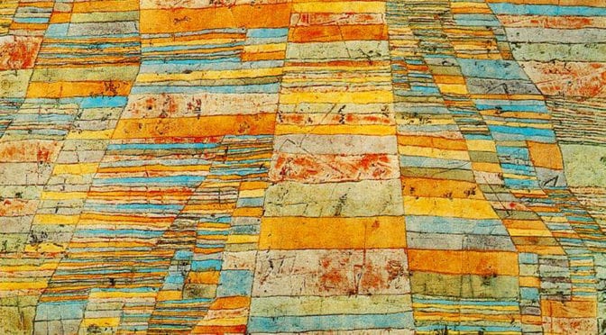
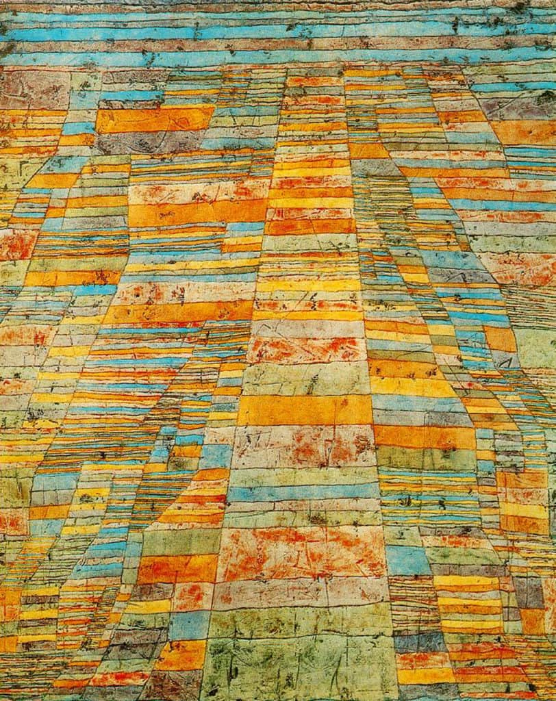
According to the one interpretation of Paul Klee’s Highways and Byways, plots of lands are used as ‘building blocks’ to offer an aerial view of the landscape in order to create the illusion of perspective and relief. “Complexity emerges geometrically by successive doublings from a central ‘highway’ to create ‘byways’ (i.e. small, more dense or compact plots of land), only to be lost again by inversely halving their number.” The largest plots forming the central ‘highway’ approach a water body (probably the River Nile since this period of Klee’s paintings came after a trip to Egypt). However, the title of Klee’s painting indicates a different interpretation than agricultural plots for the colored strata (Source: The Peacock’s Tail: Essays on Mathematics and Culture). It does seem to hint at more than an abstract painting of an agricultural landscape. Perhaps skewed by an American perspective towards the land, it might suggest terre potentiel (the potential of the land). Humans have already intervened in the landscape for agricultural uses and the river already serves as a transportation hub, both associated with the support mechanisms for urban living. “In this pattern of fields, all is order, timeless structure, with a poetic element added… in twentieth-century creative language” (Source: PaulKlee.net). It is in this ‘timeless structure of order’ that can be found the design traces of a future urban pattern, a future city that has yet to emerge from the land but the potential for its emergence is already etched in the landscape. I love this painting, not so much for what it represents in the ‘here and now’ (though it is beautiful only on these terms) but what it represents about the possible, the “undiscovered country,” …the future, where all travelers must venture but none may journey before it is time.

About Paul Klee
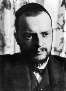
Paul Klee (1879–1940) was born near Bern, Switzerland. He studied drawing and painting in Munich for three years beginning in 1898. By 1911, he was involved with the German Expressionist group Der Blaue Reiter (The Blue Rider), founded by Wassily Kandinsky and Franz Marc. In 1914, Klee visited Tunisia. The experience was the turning point. The limpid light of North Africa awakened his sense of color. Klee gradually detached color from physical description and used it independently, giving him the final push toward abstraction. In 1920, Walter Gropius invited Klee to join the faculty of the Bauhaus. Nearly half of Klee’s work was produced during the ten years he taught at the Bauhaus. From 1931-1933, Klee taught at the Academy of Fine Arts in Düsseldorf. When the National Socialists declared his art “degenerate”, he returned to his native Bern. Klee suffered from a wasting disease, scleroderma, towards the end of his life, enduring the pain until his death in Muralto, Locarno, Switzerland, on June 29, 1940 (Source: Metropolitan Museum of Art/Wikipedia).

Visit the Artsy.net Paul Klee page here.

Read a later article about another Paul Klee painting featured in The City in Art series here.

The City in Art is a series by The Outlaw Urbanist. The purpose is to present and discuss artistic depictions of the city that can help us, as professionals, learn to better see the city in ways that are invisible to others. Before the 20th century, most artistic representations of the city broadly fell into, more or less, three categories: literalism, pastoral romanticism, and impressionism, or some variation thereof. Generally, these artistic representations of the city lack a certain amount of substantive interest for the modern world. The City in Art series places particular emphasis on art and photography from the dawn of the 20th century to the present day.

Share the knowledge!
Share

Urban Patterns | Olmsted’s Riverside Suburb in Chicago

“Take me to the river, drop me in the water,
Take me to the river, dip me in the water,
Washing me down, washing me down.”
Take Me to the River, Talking Heads

Urban Patterns | Olmsted’s Riverside Suburb in Chicago
by Dr. Mark David Major, AICP, CNU-A

We are not anti-suburbia. In fact, quite the opposite. By definition, cities grow at their edges and suburbs have played a vitally important role in the growth of cities over thousands of years even if the modern use of the term ‘suburb’ only first emerged during the 19th century. We are against badly designed suburbs. We are against the proliferation of cheap, badly designed suburbs that have spread across the American landscape like an infection since 1926 but, especially, during the post-war period, i.e. suburban sprawl. By cheap, we really mean flimsy vertical (usually baloon-frame) constructions instead of merely low-cost in gross terms, though this is also often an aspect of the suburban sprawl model. So, what does a well-designed suburb look like?

Frederick Law Olmsted’s general plan for the Riverside neighborhood of Chicago, Illinois.

You would be hard-pressed to find a better model than Frederick Law Olmsted’s Riverside suburb in Chicago, Illinois. Riverside is one of the earliest (and still best) of the 19th century suburbs, which emerged from the City Beautiful movement. Olmsted designed Riverside in 1869, a full 60 years(!) before the landmark case, Village of Euclid, Ohio v. Ambler Realty Co., in which the US Supreme Court upheld zoning as a constitutional exercise of police power. The curvilinear street network of Olmsted’s plan discretely and explicitly separates in spatial terms the suburb from the large-scale regular grid logic in Chicago by making the most direct paths for movement around – rather than through – the residential area. Streets were “laid out as to afford moderately direct routes of communications between different parts of the neighborhood (but) they would be inconvenient to be followed for any purpose of business beyond the mere supplying of the wants of the neighborhood itself. That is to say, it would be easier for any man wishing to convey merchandise from any point a short distance on one side of the neighborhood to a point a short distance on the other side to go around it rather than through it” (Olmsted quoted in Reps, 1979 about an earlier but similar plan in Berkeley, California).

Satellite view from 5 km of Riverside in Chicago, Illinois (Source: Google Earth).

This is a similar design method deployed in Middle Eastern cities to isolated residential areas by complicating routes through those areas. However, like the Middle Eastern model, Olmsted’s Riverside suburb still maintains a multitude of street connections (17 in total) to the surrounding urban context at its periphery streets. This provides a stark contrast to even many New Urbanist developments; for example, Celebration in Orlando, FL and Amelia Park in Fernandina Beach, FL, which both only have three street connections to the surrounding urban context. The real genius of Olmsted’s Riverside plan achieves discrete separation from the surrounding urban context in spatial terms without relying upon interruptus in extremis (using the absolute minimum of external street connections, which is mathematically one), which lies at the core of the suburban sprawl model associated with Euclidean zoning and roadway classifications of modern transportation planning (and later, admittedly, the cost-savings aims of developers and home builders). So, we are not against suburbs. All we are saying is. if we are going to build suburbs – and we have to, it’s a fact – make sure they are damn good ones.

(Updated: April 13, 2017)

Urban Patterns is a series of posts from The Outlaw Urbanist presenting interesting examples of terrestrial patterns shaped by human intervention in the urban landscape over time.

Share the knowledge!
Share

Dog Shits in Suburban Sprawl Hell, Property Values Rise 20%

A True Story about Shit
by Dr. Mark David Major, AICP, CNU-A, The Outlaw Urbanist contributor

Today, I found myself in single-family suburban sprawl hell, somewhere in Northeast Florida, with my dog, Izzy. The reason is unimportant. However, being a dutiful dog, Izzy indicated she needed to go for a walk. (Note: She is 4 years old next month and the cutest dog with the sweetest disposition… but that’s beside the point). So, I hooked her to the leash and started to walk her through a neighborhood, which is the very definition of suburban sprawl. Yes, there was not any street inter-connectivity and we have to retrace our route into this neighborhood, giving us the “pleasure” of seeing the same Mega Mediterranean homes not once but twice. Of course, the homes are only Mega Mediterranean along the front yard facades. Along the side yards, the true nature of the homes as basic wood frame construction with really cheap siding, sitting on 1/4 acre lots, is obvious. Most of the lawns were neatly manicured with St. Augustine grass (by the way, not really a grass… it’s a weed but whatever), as one might expect. In spending about 20 minutes in this neighborhood, I passed about a half of dozen people at 6:00 pm in the evening. None of these people said hello.

In fact, only one person spoke to me. After Izzy had done ‘her business’ (meaning she pooped) in a front yard and I was bending down with my doggy poop bag to pick it up, a woman came rushing out of her house to tell me, “I don’t like dogs pooping in my yard.” I looked at her incredulously and replied, “I’m picking it up.” She said (and I’m not kidding), “I know but I spent a lot on money on this yard and I don’t want it messed up by dogs pooping in it.” As you might expect, I stared in shock at this woman like she was a crazy person. She did not make her political position on urine clear to me. I pointed out, “it’s fertilizer.” She then added, “I know but I have dogs too and I don’t let them poop in my yard.” I’m not sure but this may have been a ‘suburban code’, meaning ‘I make sure my dogs poop in the neighbors’ yards.’ I replied, 
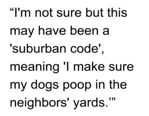
“Call the police, I’m sure it must be a crime,” turned around and walked back the way we came out of the neighborhood, all the while dutifully carrying my doggy poop bag and carefully navigating through multiple piles of dog shit in the neighborhood common areas. Needless to say, Izzy and I will never be walking in that neighborhood again (not that it was ever likely anyway).

My normal experience in a historic, traditional neighborhood has always been when Izzy poops in someone’s yard, I dutifully pick it up and, if it is noticed, the homeowners usually say, “thank you.” Suburban sprawl breeds intolerance of the stranger and the unfamiliar… and, apparently, acute cases of coprophobia (an irrational fear of feces).

Share the knowledge!
Share

The Audacity of Audacity | DOT Secretary on Spending Binge | Planetizen

Transportation Secretary on Spending Binge Before Leaving Office | Planetizen

Ray LaHood, U.S. secretary of transportation, pauses while speaking during the U.S. Export-Import Bank annual conference in Washington, D.C., U.S., on Friday, April 5, 2013. Photographer: Andrew Harrer/Bloomberg via Getty Images

In February 2013, outgoing US DOT Secretary Ray LaHood was bemoaning the need for an additional $15 billion a year to fix potholes (see The Outlaw Urbanist post, “The Weight of Debt,” 2/7/13). Two months later, LaHood is apparently spending money like a drunken sailor in a whorehouse (no offense to sailors… or whores), throwing out $1.5B in grants like it was candy (10% of the total amount he previously said was desperately needed to fill potholes). Now, I’m sure local mayors and governments do, indeed, appreciate the largesse from DoT but there’s something incredibly unseemly about this situation.

From the article:

“LaHood is pushing the limits of his power. He recently earmarked $100,000 for the construction of a one-eighth scale miniature railroad in the backyard of his private home.”

See what I mean? The American taxpayers’ money at work on behalf of Ray LaHood. Surely, that has got to be illegal? Right? Generally, this is how you book a reservation at the Illinois Governors’ Memorial Wing of the United States Penitentiary in Marion, Illinois.

You can read the full article here: Transportation Secretary on Spending Binge Before Leaving Office | Planetizen

Share the knowledge!
Share

Gobsmacked by Those Crazy Germans | The ‘Tropical Islands’ Resort In Germany

Concrete Blonde sent a link to this Business Insider photographic essay under the subject header “Porn for Architects and Urban Planners.” Thank goodness a picture is worth a thousand words because 15,000 words seem woefully inadequate to explain what you can see in 15 photographs. Business Insider does not mention the designer or owner but we’re guessing Willy Wonka and Jerry Jones, respectively.

Excerpt from article:

“South of Berlin, a giant airplane hangar on a former Soviet airbase has been transformed into a sunny, sandy resort. Known as the Tropical Islands, the space is 1,181 feet long, 689 feet wide, and 351 feet tall. To put that in perspective, eight football fields and the Statue of Liberty could fit inside. The resort has been open since 2004, and attracts around 1 million visitors each year…. Despite Germany’s chilly winters, the temperature inside stays at a balmy 78 degrees. There are 13 different bars and restaurants, miniature golf, flamingos, and the biggest spa in Europe at just under 33,000 square feet.”

See more photographs here: The ‘Tropical Islands’ Resort In Germany | Business Insider

Share the knowledge!
Share