Tag Archives: The Urban Pattern

Urban Patterns | Philadelphia, Pennsylvania USA

“Oh brother, are you gonna leave me,
Wastin´ away on the streets of Philadelphia.”
— Streets of Philadelphia, Bruce Springsteen

Urban Patterns | Philadelphia, Pennsylvania USA
by Dr. Mark David Major, AICP, CNU-A

Philadelphia is the largest city in the Commonwealth of Pennsylvania and the fifth-most populous city in the United States, with an estimated population of 1,567,442 and more than 6 million in the seventh-largest metropolitan statistical area, as of 2015. Philadelphia is the economic and cultural anchor of the Delaware Valley—a region located in the Northeastern United States at the confluence of the Delaware and Schuylkill rivers with 7.2 million people residing in the eighth-largest combined statistical area in the United States. In 1682, William Penn, an English Quaker, founded the city to serve as capital of the Pennsylvania Colony. Philadelphia played an instrumental role in the American Revolution as a meeting place for the Founding Fathers of the United States, who signed the Declaration of Independence in 1776 and the Constitution in 1787 (Source: Wikipedia).

Satellite view from 5 km of Philadelphia, Pennsylvania USA (Source: Google Earth).

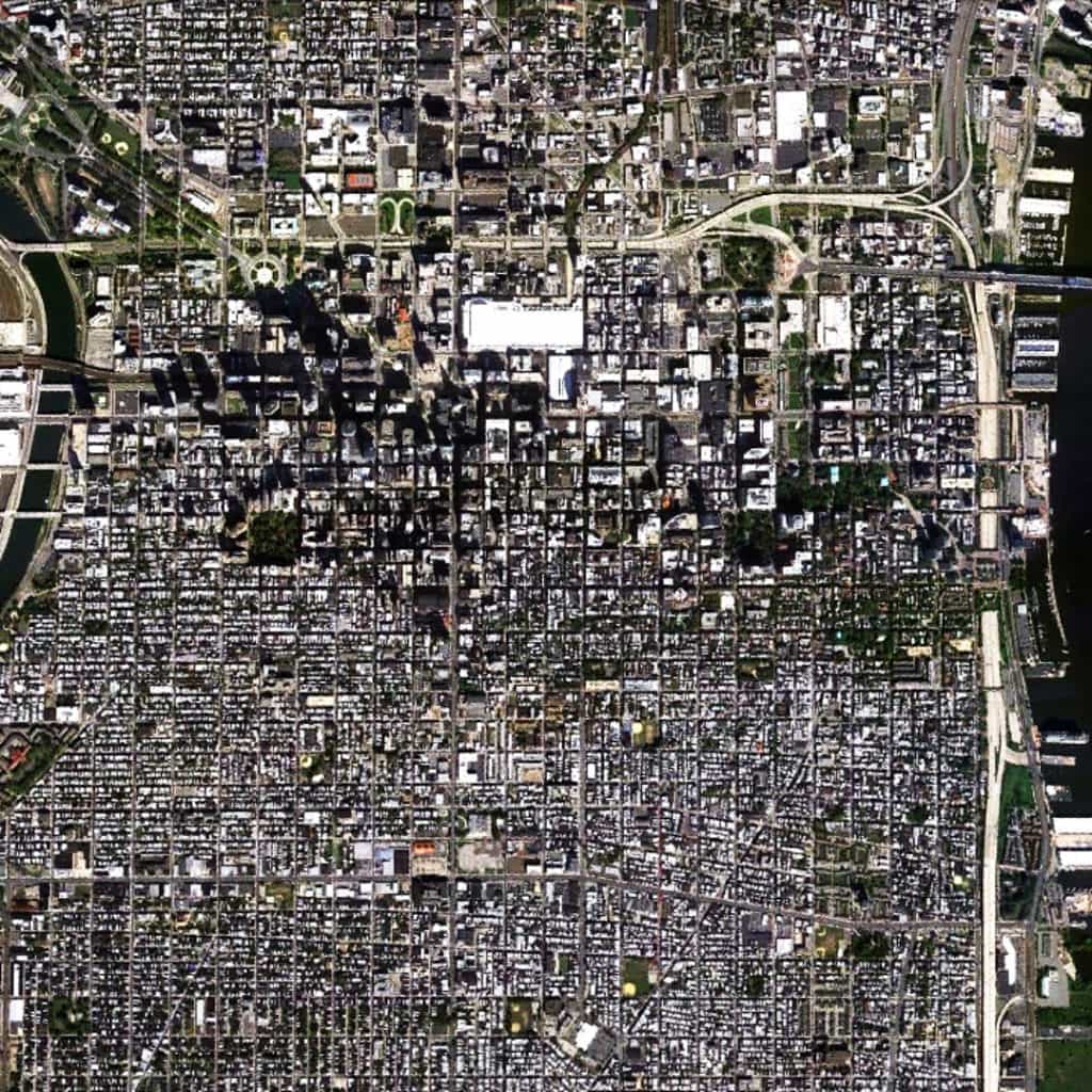
There are two remarkable yet seemingly contradictory things about the urban pattern in Philadelphia; in particular, within the bounds of William Penn’s original 1682 plan for the city. First, is the remarkable degree to which the plan has changed over more than 330 years of development. Most often, this has occurred through the manipulation of block sizes (upsizing and subdividing of urban blocks) even if the Vine Street Expressway (Interstate 676) and Delaware Expressway (Interstate 95) ringing the bounds of the original plan might, at first glance, draw the eye to these large-scale interventions. Second, is the remarkable degree to which the integrity of the original Penn plan for the city has endured literally thousands of small-scale interventions over more than 330 years of development. Taken together, this points to something even more remarkable, which is the instrumental power of the regular grid to be simultaneously flexible for and resilient to change over time.

(Updated: April 1, 2017)

Urban Patterns is a series of posts from The Outlaw Urbanist presenting interesting examples of terrestrial patterns shaped by human intervention in the urban landscape over time.

Share the knowledge!
Share

Urban Patterns | The Village | Portmeirion, Wales

“But still we walk into the valley,
And others try to kill the inner flame,
We’re burning brighter than before,
I don’t have a number, I’M A NAME!”

Back in the Village, Iron Maiden

Urban Patterns | The Village | Portmeirion, Wales
by Dr. Mark David Major, AICP, CNU-A

The grounds of the Hotel Portmeirion, a resort near Penrhyndeudraeth in North Wales, famously served as the doppelgänger for “The Village” in the 1960s television series, The Prisoner. Portmeirion is a popular tourist village in Gwynedd, North Wales. It was designed and built by Sir Clough Williams-Ellis between 1925 and 1975 in the ‘style’ of an Italian village. From 1,500 feet above, “The Village” appears relatively unchanged some forty years later.

Satellite view from 1 km of Portmeirion, Wales (Source: Google Earth).

Interestingly, the layout of Portmeirion appears more akin to the layout of a theme park, zoo, or even a modern golf course. There are few distinctive features composed in plan in a manner consistent with traditional settlement – Italian or otherwise – or a modern suburban forms. Instead, the layout is composed of a series of medium- and large-scale loop roads; the largest one being further to the east associated with Castell Deudraeth, which is a restored Victorian building and gardens that re-opened as a hotel in 2001. The most distinctive of these roads incorporate the grounds of the Hotel Portmeirion itself, forming an U-shaped semi-circular vehicular road in relation to the Afon Dwyryd shoreline in the south. This means the most accessible routes for pedestrians (aka tourists) tend to traverse (or, at least, want to) diagonally across the large green spaces of Williams-Ellis’ plan but within the limitations imposed its hard and landscaping features, i.e. paved areas, reflection ponds, etc. Be seeing you.

(Updated: March 29, 2017)

Urban Patterns is a series of posts from The Outlaw Urbanist presenting interesting examples of terrestrial patterns shaped by human intervention in the urban landscape over time.

Share the knowledge!
Share

Urban Patterns | Venice, Italy

“Enter this sublime corrosion,
Venice drowning in emotion.”
Venice Drowning, Duran, Duran

Urban Patterns | Venice, Italy
by Dr. Mark David Major, AICP, CNU-A

Venice is a city in northeastern Italy and the capital of the Veneto region. It is situated in a group of 117 small islands that are separated by canals and linked by bridges. These are located in the shallow Venetian Lagoon, an enclosed bay that lies between the mouths of the Po and the Piave Rivers. Parts of Venice are renowned for the beauty of their settings, their architecture, and artwork. The lagoon and a part of the city are listed as a World Heritage Site. In 2014, 264,579 people resided in Comune di Venezia, of whom around 55,000 live in the historic city of Venice (Centro storico). Together with Padua and Treviso, the city is included in the Padua-Treviso-Venice Metropolitan Area with a total population of 2.6 million people. Venice was a major financial and maritime power during the Middle Ages and Renaissance, and a staging area for the Crusades and the Battle of Lepanto, as well as a very important center of commerce (especially silk, grain, and spice) and art in the 13th century up to the end of the 17th century. The city is considered to have been the first real international financial center which gradually emerged from the 9th century to its peak in the 14th century, making it a wealthy city throughout most of its history (Source: Wikipedia).

Venice has been a source of fascination for centuries for a variety of reasons including, rightly so, its architecture and urban design. In many ways, Venice seems unique. Its island location seems to allow the city to operate as an ‘almost discrete’ urban system. At least, much more so than most cities. It incorporates a mix of transportation modes including pedestrian paths, a rail station, ports, and internal water navigation, e.g. the canals. Venice is an urban pattern ‘frozen in time’ because of historical conservation efforts during the 20th century, almost as much – if not more so – for maintaining the delicate man-made ecosystem of Venice due to subsidence (i.e. gradual lowering of the city into the sea) as for architectural and urban design aesthetics. Venice is ‘frozen’ into its deformed grid layout much in the same manner as the Pilot Plan of Brasilia is ‘frozen’ in its modernist, geometric layout.

Satellite view from 5 km of Venice, Italy (Source: Google Earth).

Nonetheless, there are many interesting things to note. The intricacy of the deformed grid layout indicates a well-defined and easily-understood neighborhood pattern in Venice, despite the lack of a readily-apparent geometry in the ‘bird’s eye view’ of the layout. Block sizes appear larger and more geometrically regular at the outer edges of the island (for example, to the north at the water’s edge) and smaller towards the center of the island (for example, at the bend in the Grand Canal). Venice’s street system also seems to have evolved over time to privilege the edge-to-edge relationship from one shoreline to another with longer, straighter streets intersecting these streets for transverse movement, especially closer to the outer edges of the island; for example, to the north and south. This leaves the patterning of the center-to-edge relationship for movement in the Venice urban network to the canal system itself, especially in the relationship between the rail station located at the water’s edge to the west and the Grand Canal itself. Collectively, this seems to represent something of an European inversion (and a very particular one at that) in formal terms compared to the suburban street network pattern of post-war American cities (such as Las Vegas or Phoenix), where very long edge-to-edge, super grid streets are geometrically determined by the cardinal directions and interstitial streets tend to be shorter by comparison. Nonetheless, the dynamic of Venice’s train station in relation to this urban pattern is somewhat replicated by the airport in the American model.

(Updated: March 28, 2017)

Urban Patterns is a series of posts from The Outlaw Urbanist presenting interesting examples of terrestrial patterns shaped by human intervention in the urban landscape over time.

Share the knowledge!
Share

Urban Patterns | El Tikkawin, Sudan

“How far is it from, how far is it from,
Walk through the storms, go through the storms.”
Storms in Africa, Enya

Urban Patterns | El Tikkawin, Sudan
by Dr. Mark David Major, AICP, CNU-A

El Tikkawin is a settlement located on the Upper Nile River in Sudan at 18°13’12” north of the equator and 33°55’12” east of the Greenwich Prime Meridian. Demographic and population data is not readily available but it appears to be a large town. The town is located adjacent to rich agricultural lands associated with the seasonal flooding of the Nile River. A large-scale (in relative terms) regular grid characterizes the largest area of the town, probably reflective of thousands of years of Egyptian influence in the Upper Nile region. Within the interstitial areas of the regular grid are the more intricate street networks more commonly associated with Middle Eastern settlements. This is a similar model to American suburban sprawl in the 20th century with the important exception that the interstitial street networks in El Tikkawin do not eliminate almost entirely connections at the periphery of the interstitial area, which is the case in the worst examples of American suburban sprawl.

Satellite view from 5 km of El Tikkawin, Sudan (Source: Google Earth).

This suggests a more sustainable and compact spatio-functional model in El Tikkawin compared to the dysfunction associated with American suburbs (being almost entirely auto-dependent). The regular grid is mostly absent in what appears to be the oldest section of El Tikkawin (to the right, immediately adjacent to Upper Nile agricultural lands). This oldest part of town is mostly characterized by a deformed grid layout. Finally, for anyone who ever criticized space syntax by asking to be shown an axial line… well, here they are… marked in the landscape. Tracks mark the path through large (undeveloped) open spaces to-and-from the surrounding agricultural lands and other parts of El Tikkawin as people linearized their use of space during their everyday activities.

(Updated: March 24, 2017)

Urban Patterns is a series of posts from The Outlaw Urbanist presenting interesting examples of terrestrial patterns shaped by human intervention in the urban landscape over time.

Share the knowledge!
Share

Urban Patterns | Savannah, Georgia USA

“Time to call on old Anne Hannah
While she sits there wishing for her last reward
Peaceful Sunday in Savannah
Don’t you dare go fishin, son, Amen.”
Sunday in Savannah, Rosemary Clooney

Urban Patterns | Savannah, Georgia USA
by Dr. Mark David Major, AICP, CNU-A

Savannah is the oldest city in the U.S. state of Georgia and is the county seat of Chatham County. Established in 1733 on the Savannah River, the city of Savannah became the British colonial capital of the Province of Georgia and later the first state capital of Georgia. A strategic port city in the American Revolution and during the American Civil War, Savannah is today an industrial center and an important Atlantic seaport. It is Georgia’s fifth-largest city and third-largest metropolitan area. Savannah’s architecture, history, and reputation for Southern charm and hospitality are internationally known. The city’s former promotional name was the “Hostess City of the South,” a phrase still used by the city government. An earlier nickname was “the Forest City”, in reference to the large population and species of oak trees that flourish in the Savannah area. These trees were especially valuable in shipbuilding during the 19th century. In 2014, Savannah attracted 13.5 million visitors from across the country and around the world. Savannah’s downtown area is one of the largest National Historic Landmark Districts in the United States (Source: Wikipedia).

Satellite view from 15 km of Savannah, Georgia USA (Source: Google Earth).

The Oglethorpe ward plan of Savannah sits on the banks of the Savannah River to the north (distinguished by the squares, which are darker in this image). The street alignments of the ward plan extend southwards to define the north-south streets of a larger orthogonal grid south of the Oglethorpe plan. Interstate 516, East Derenne Street, and the Harry S. Truman Parkway (road with wandering alignment to the east) effectively form a ‘ring road’ around the urban core to the south, west and east. The large blocks and offset grid to the west of the Oglethorpe plan introduce deformation into the layout to maximize the number of buildable lots in relation to the topography of the Savannah River (i.e. the port). The large airport to the extreme south is the Hunter Army Airfield. Except for Hutchinson Island itself (in Georgia), there is very little development north of Savannah in South Carolina except further north away from the river, perhaps due to a combination of environmental and jurisdictional factors.

(Updated: March 23, 2017)

Urban Patterns is a series of posts from The Outlaw Urbanist presenting interesting examples of terrestrial patterns shaped by human intervention in the urban landscape over time.

Share the knowledge!
Share