Space Syntax for Dummies, Part 3
RESULTS
by Dr. Mark David Major, AICP, CNU-A, The Outlaw Urbanist contributor
The final part of this three-part introduction to the basics of space syntax reviews some of the earliest – and most crucial – research results about pedestrian and vehicular movement using the axial map (see above) of urban street networks. Again, Part 3 is somewhat tailored to an American audience since it is based on excerpts from Chapter 3 of my forthcoming Relentless Magnificence: The American Urban Grid.
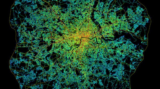
Early space syntax studies demonstrated the potential of the axial map to reveal important functional characteristics about the urban spatial network.  This is because urban space tends to be linear with streets, boulevards, avenues, and alleys but with only occasional (in relative terms) convex elements such as squares and public open space (Hillier, 2005). This can been seen most clearly in axial map of Greater London within the M25 (see below). The axial map represents the most optimal line of sight passing through every accessible space in the London street network until accounting for all accessible spaces and, then, measuring and graphically representing the spatial configuration of that network in terms of topological depth (see Space Syntax for Dummies, Part 2). Penn et al (1997) define the axial map as “the minimal set of axial lines such that the set taken together fully surveys the system, and that every axial line that may connect two otherwise-unconnected lines is included” (Turner et al, 2004: 428).
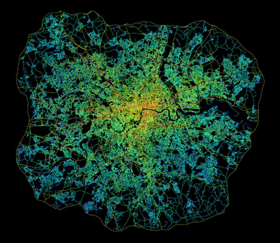
Topological depth (refer back to the explanation in Space Syntax for Dummies, Part 2) can be measured based on global integration (or in topological terms, betweenness) because it measures the configurational relationship of all spaces to all others across the entire spatial network. It can also be measured to provide a more localized picture of spatial configuration by measuring local integration (or in topological terms, choice). The latter can be most easily understood if you imagine yourself standing at the intersection of two streets. Simultaneously, you are in and can see along the length of these two streets but also see all other streets – as well as other urban functions, i.e. level of use by people and cars, land uses, building heights. etc. – intersecting with them from your position. Or, topological depth can be measured in terms of radii between these two extremes. The space syntax model of Greater London within the M25 (see above) does so by limiting the radius based on the mean depth from the most globally integrated street; in this case, Oxford Street. The space syntax software automatically colors the degree of integration for each axial line. The color range is from red (most integrated) through orange, yellow, and blue, light blue, blue to purple (most segregated). At this point, the space syntax model is still a purely mathematical representation of configurational pattern. The analysis did not yet take in account other urban functions such as land use, building heights or population density though, of course, this information can be inputted into the model using GIS. Despite this, the axial map appears to provide a very realistic picture of how London operates as an urban spatial network.
An early key finding of space syntax research was establishing there is a relationship between the spatial configuration of the urban grid and patterns of pedestrian and vehicular movement (Hillier et al, 1993; Penn and Hillier, 1998). Penn and Hillier (1998) found that integrated spaces carry larger movement flows than more segregated ones, and the effects were strong and consistent. The key discovery was the correlation between movement flows and a purely configurational measure of the urban spatial network before ever taking into account the location of attractors or generators of movement. This led to the formulation of the theory of natural movement. The theory of natural movement states that movement patterns in the urban environment arise naturally from the way the urban grid organizes the simplest routes to and from all locations involving the fewest changes of changes in that grid.  This means it is the design of the urban pattern in the shape of its grid that most matters. In this sense, natural movement is akin to a background effect of the urban grid since most movement in space will tend to be through-movement that is passing through a space on its way to somewhere else in the urban grid. The distribution of activities and land uses then has the potential to further intensify, or detract from, the background effects of natural movement (Hillier, 1996; Hillier and Vaughan, 2007).
A fundamental concept to arise from the theory of natural movement is the city as a movement economy. Namely, it is the pattern of the spatial network as generated by the urban grid, rather than the traditional planning emphasis on origin and destination matrices, which is the fundamental thing about the functioning of cities (Hillier, 1996). The urban grid generates a probabilistic but predictable pattern to the way people move through and occupy spaces in cities. Some spaces receive more movement and use because they are shallower within the spatial network whereas others are deeper and receive less. The spatial configuration of the urban grid generates a pattern of “attraction inequalities” whereby land uses tend to locate to exploit these potentials based on the pattern of natural movement (Hillier, 2002; 154). Retail will occupy more strategic locations to capitalize on the potential for passing trade. According to Hillier (2005), “this is not… to deny attraction… it is common sense (that) people make trips because the shops are there… but (attraction) is not fundamental” (11).
This early finding has led to a considerable body of research on how people move and occupy space, and the relationship to spatial configuration (see below and compare to the space syntax model of the Tate Gallery, Millbank in Space Syntax for Dummies, Part 1).
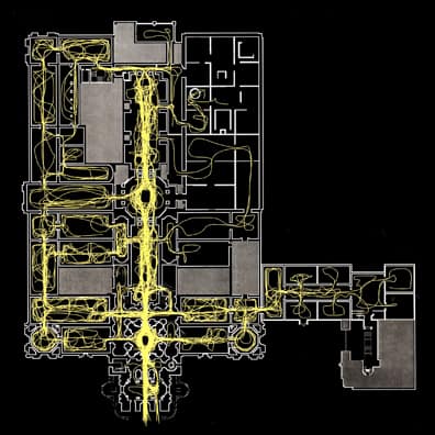
This simple introduction on The Outlaw Urbanist only begins to scratch the surface of the volume of research available from the use of space syntax over the previous 30 years. However, it should provide you with a solid foundation to jump into this vast collection of research, most of which is freely available online. For example, more than 500 research papers composing the proceedings of every Space Syntax Symposia for nearly twenty years is freely available for download via the Space Syntax Network here. Also, Chapter 3 of my forthcoming Relentless Magnificence: The American Urban Grid will delve more deeply into space syntax research and issues of methodology/terminology over the last 20 years.
Additional Reading and References
For your convenience, the easiest reading below is indicated with an *asterisk.
Hillier, Bill and L. Vaughan. 2007. “The city as one thing”, Progress in Planning, 67(3): 205-230. Article available online for download from University College London here.
Hillier Bill. 2005. “The art of place and the science of space”, World Architecture, Special Issue on Space Syntax. Beijing: 11(185): 24-34 (in Chinese); 96-102 (in English). Article is currently available online for download via the Scribd here. Registration required.
*Hillier Bill. 2002. “A theory of the city as object: or, how spatial laws mediate the social construction of urban space”, Urban Design International, 7: 153–179. Article available online for download from the Nordic Urban Design Association here.
*Hillier, Bill. 1996. Space is the Machine: A Configurational Theory of Architecture. Cambridge: Cambridge University Press. Digital eBook is available for free download from University College London here.
*Hillier, Bill, M.D. Major, J. Desyllas, K. Karimi, B. Campos, T. Stonor. 1996. Tate Gallery, Millbank: A Study of the Existing Layout and New Masterplan Proposal. Technical Report, Unit For Architectural Studies, Bartlett School of Graduate Studies, University College London. Report is available for free download from University College London here.
*Hillier, Bill, A. Penn, J. Hanson, T. Grajewski, J. Xu. 1993. “Natural Movement: or, configuration and attraction in urban pedestrian movement”, Environment and Planning B: Planning and Design, 20: 29-66. Article available online for download from University College London here.
*Major, M.D. 2014. Relentless Magnificence: The American Urban Grid. Jacksonville, Florida: Forum Books, forthcoming.
Penn, Alan, B. Hillier, D. Banister, Xu, J. 1998. “Configurational modeling of urban movement networks”, Environment and Planning B: Planning and Design, 25: 59-84. Article available online for download from University College London here.
Turner, Alasdair. 2004. Depthmap 4: A Researcher’s Handbook. Bartlett School of Graduate Studies, UCL, London. Handbook available online for download from University College London here.

