Category Archives: Urban Patterns

Urban Patterns | Salt Lake City, Utah USA

“Day is done but there’s no job to be found in Salt Lake City,
Room’s cold no one to hold so I’ll just walk around,
And think of all the times that she said that she loved me,
But that’s just a mem’ry in Salt Lake City.”
— Salt Lake City, Hank Williams, Jr.

Urban Patterns | Salt Lake City, Utah USA
by Dr. Mark David Major, AICP, CNU-A
Originally posted on May 17, 2013

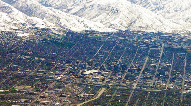
This week we are looking at the urban pattern of Salt Lake City, Utah USA in honor of where CNU21 (21st Congress for New Urbanism Conference) will be (was) held May 29-June 1, 2013. Salt Lake City was founded in 1847 in what was still Mexican Territory by Brigham Young, Isaac Morley, George Washington Bradley and several other Mormon followers, who extensively irrigated and cultivated the arid valley. Brigham Young claimed to have seen the area in a vision prior to their arrival. Due to its proximity to the Great Salt Lake, the city was originally named “Great Salt Lake City” but the word “great” was dropped from the official name in 1868. Although Salt Lake City is still home to the headquarters of The Church of Jesus Christ of Latter-day Saints (LDS Church), less than half of its population are Mormons today (Source: Wikipedia).

Satellite view form 10 km of Salt Lake City, Utah (Source: Google Earth).

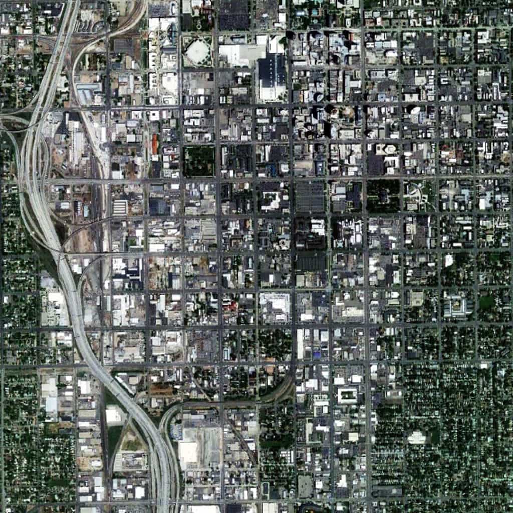
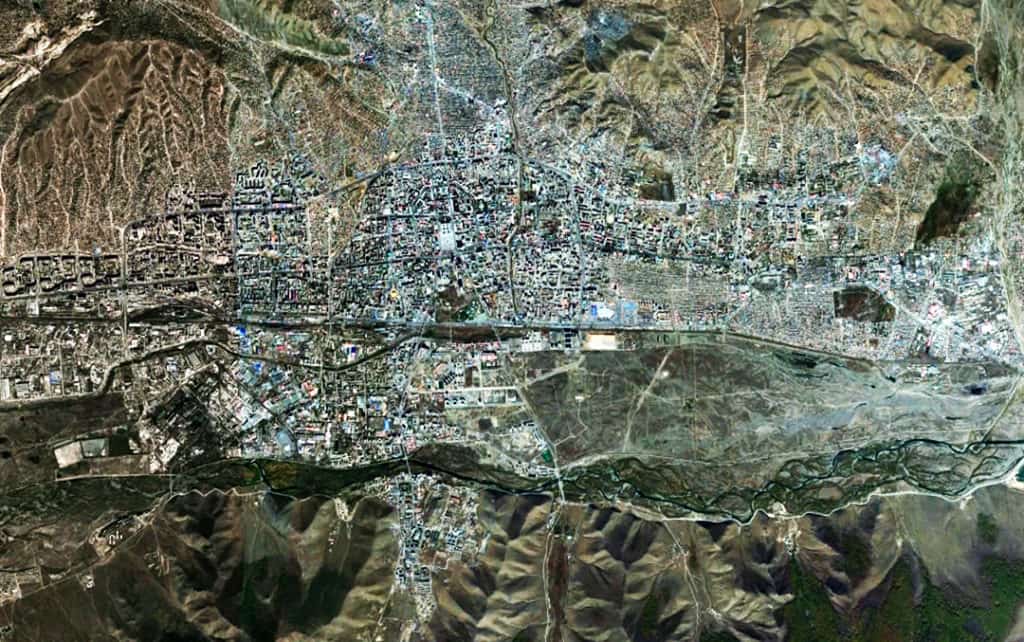
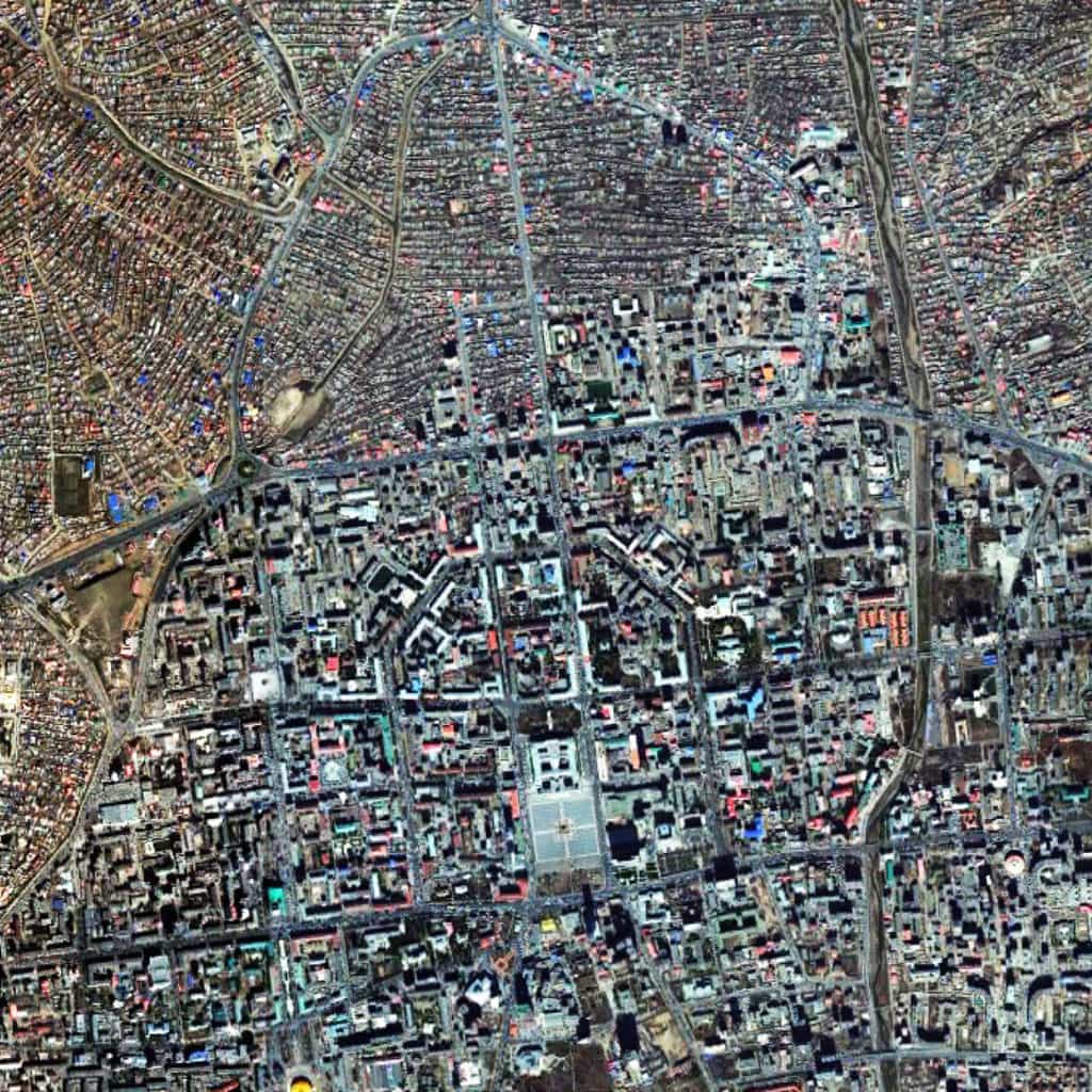
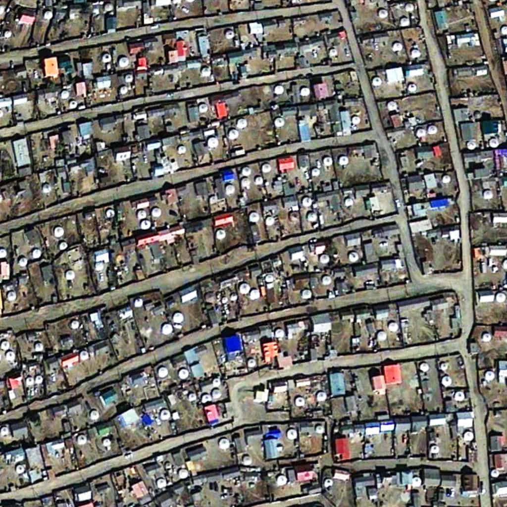
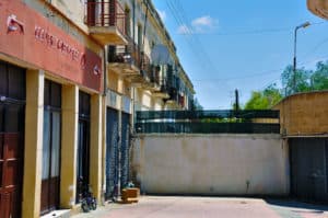
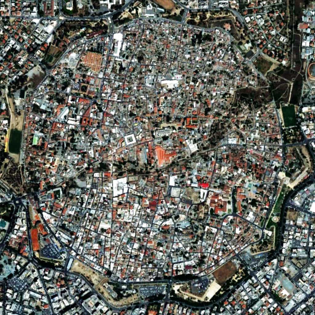
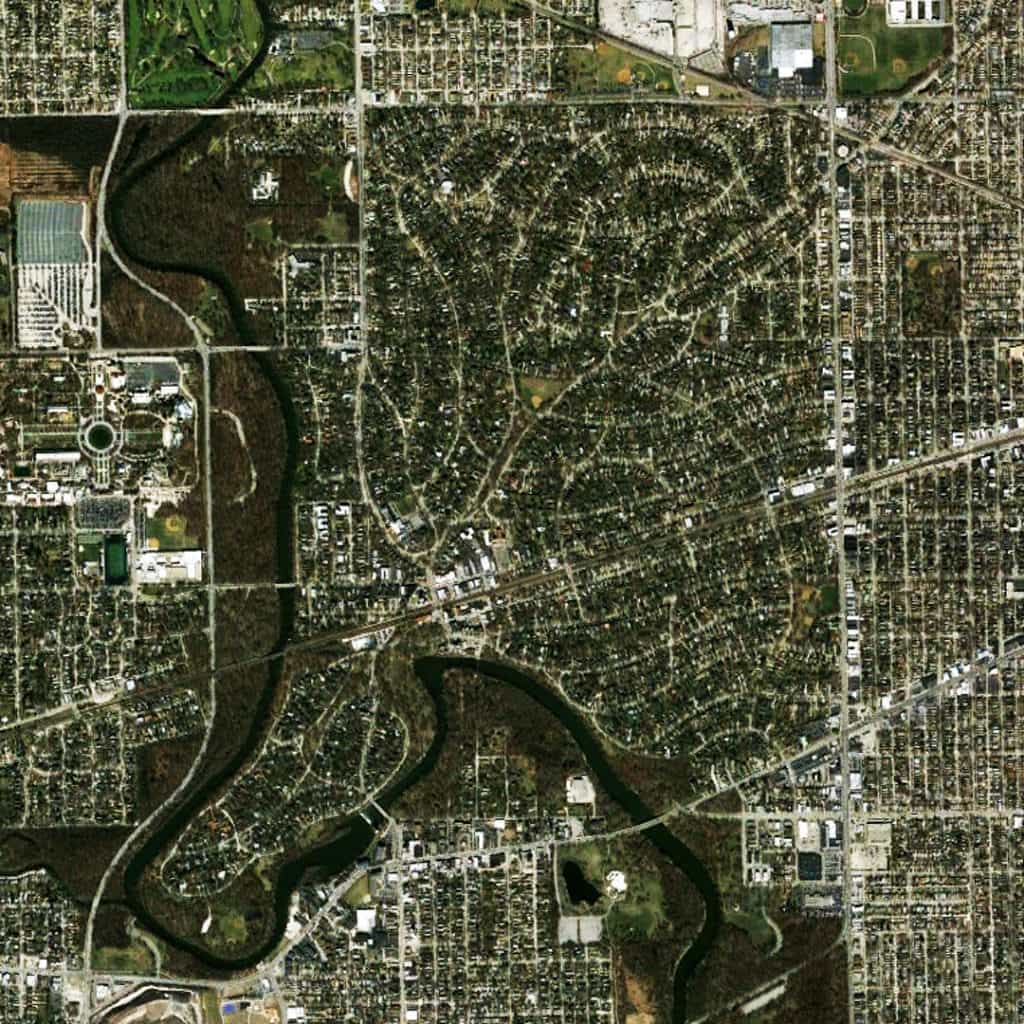
The urban pattern of Salt Lake City is extremely interesting for an American city due to the emphasis on square blocks. This is atypical for most pre-20th century American cities, which usually and rapidly developed using a well-defined land speculation process. 19th-century American land speculators tended to elongate urban blocks into a rectangular shape (for example, in Denver and Chicago) to maximize the number of available lots for sale and, hence, their profits. However, Salt Lake City was founded by the Mormons, who were (initially) more interested in the social order of their settlement as imprinted in its physical pattern than personal economic gain. So, they laid out the settlement using a regular grid composed of square blocks. Salt Lake City is a perfect illustration of Poor Richard’s maxim that, “Compact block sizes are about community. Ample block sizes are about profit.”

(Updated:  May 18, 2017)

Urban Patterns is a series of posts from The Outlaw Urbanist presenting interesting examples of terrestrial patterns shaped by human intervention in the urban landscape over time.

Share the knowledge!
Share

Urban Patterns | Ulaanbaatar, Mongolia

“There’s a tent in the center of town,
Where the people can gather around.”
Tent in the Center of Town, Sara Groves

Urban Patterns | Ulaanbaatar, Mongolia
by Dr. Mark David Major, AICP, CNU-A

Satellite view from 15 km of Ulaanbaatar, Mongolia (Image: DigitalGlobe © 2013, Courtesy of Google Earth).

Ulaanbaatar, Mongolia is a fascinating settlement for a variety of reasons. The city was founded in 1639 as a movable (i.e. nomadic) Buddhist monastic center. In 1778, it settled permanently in its present location at the junction of the Tuul and Selbe rivers. Before that, it changed location 28 times with each site selected for ceremonial reasons (Source: City of Ulaanbaatar). At first glance from 60,000 feet (see above), the urban pattern appears to be strongly characterized by a predominantly linear structure oriented to the Tuul River, the Trans-Siberian railway line, and Peace Avenue, all of which (more or less) runs parallel to each other in an east-to-west direction. However, this is somewhat misleading due to radical differences in building scale between (mainly) residential areas in the periphery and the non-residential areas of the settlement in the city center. This is clearer in a view of the settlement from 20,000 feet (see below), which reveals the street network is actually a deformed grid layout, very characteristic of European towns. The difference in the scale of building construction in the city center (large buildings and blocks) compared to the surrounding residential areas (small buildings in elongated blocks) is quite distinctive.

Satelitte view from 5 km of Ulaanbaatar, Mongolia (Image: DigitalGlobe © 2013, Courtesy of Google Earth).

Closer examination of a residential area reveals a reason for the radical differences in building scale in the settlement (see below view from 6,000 feet). The residential area is characterized by walled compounds, many of which have a yurt (circular structure generally in white in the below image). A yurt is a portable, bent dwelling structure traditionally used in nomadic cultures from the steppes of Central Asia. The structure comprises a crown or compression wheel usually steam bent, supported by roof ribs which are bent down at the end where they meet the lattice wall (again steam bent). The top of the wall is prevented from spreading by means of a tension band which opposes the force of the roof ribs. The structure is usually covered by layers of fabric and sheep’s wool felt for insulation and weatherproofing (Source: Wikipedia). Many of the compounds also have a permanent structure, which tends to have colorful roofs. All of these physical features, combined with the nomadic origins of the settlement, makes Ulannbaatar one of the most fascinating urban patterns on our planet.

Satellite view from 500m of Ulaanbaatar, Mongolia (Image: DigitalGlobe © 2013, Courtesy of Google Earth).

(Updated:  May 12, 2017)

Urban Patterns is a series of posts from The Outlaw Urbanist presenting interesting examples of terrestrial patterns shaped by human intervention in the urban landscape over time.

Share the knowledge!
Share

Urban Patterns | Nicosia, Cyprus

“Leave them kids alone!
All in all it’s just another brick in the wall,
All in all you’re just another brick in the wall.”
Another Brick in the Wall (Part 2), Pink Floyd

Urban Patterns | Nicosia, Cyprus
by Dr. Mark David Major, AICP, CNU-A

Nicosia is the largest city on the island of Cyprus. It is located near the center of the Mesaoria plain on the banks of the River Pedieos. It is the capital and seat of government of the Republic of Cyprus. As such, it is the farthest southeast of all European Union member states’ capitals. It has been the capital of Cyprus since the 10th century. The Greek Cypriot and Turkish Cypriot communities of Nicosia segregated into the south and north of the city respectively in 1963 following the outbreak of violence. This division became a militarized border between the Republic of Cyprus and Northern Cyprus after Turkey invaded the island in 1974, occupying the north of the island including northern Nicosia.

Street walled off from access in Nicosia, Cyprus.

Today, the northern part of the city is the capital of Northern Cyprus, a state recognized only by Turkey, which is considered occupied Cypriot territory by the international community. Nicosia has been in continuous habitation since the beginning of the Bronze Age (i.e. over 4,5000 years) when the first inhabitants settled in the area. Nicosia later became a city-state known as Ledra or Ledrae, one of the twelve kingdoms of ancient Cyprus built by Achaeans after the end of the Trojan War. Remains of old Ledra today can be found in the Ayia Paraskevi hill in the southeast of the city (Source: Wikipedia).

Satellite view from 2.5 km of Nicosia, Cyprus (Source: Google Earth).

Nicosia, Cyprus has an interesting urban pattern for a variety of reasons. First, after the fall of the Berlin Wall, it is the only remaining divided city in the world (the demarcation is the “Green Line”, evident at the center of the above satellite image from 8,000 feet) between the Turkish north and the Greek south. Second, the city is characterized by a deformed grid layout. However, within the walls of the old city, the pattern of streets in the Turkish north is more characteristic of Middle Eastern cities where smaller block sizes and narrow street widths serve to complicate continuous lines of sights. In the Greek south, street widths are wider, blocks are larger, and the layout is more geometric in nature. This indicates a clear distinction in the social construction of space by two cultures (predominantly Turkish/Islāmic in the north and Greek/Orthodox Christian in the south). However, as interesting as this is, it is not the most remarkable thing about Nicosia. When you zoom out to encompass more of the surrounding urban context outside the walls of the old city (see header image from 15,000 feet), the deformed grid of the city is everywhere more characterized (in relative terms by comparison to the street pattern within the old city walls) by wider and straighter streets, larger blocks, and a more geometrical layout as a whole; again, more so to the south than the north. This ably demonstrates the necessity of urban functionality in overcoming the social imprint of space in order to better mediate the relationship between city center and the ever-expanding edges of that city.

(Updated: April 19, 2017)

Urban Patterns is a series of posts from The Outlaw Urbanist presenting interesting examples of terrestrial patterns shaped by human intervention in the urban landscape over time.

Share the knowledge!
Share

Urban Patterns | Hashima, Japan

“Islands in the stream, that is what we are, no one in between…”
Islands in the Stream, Bee Gees

Urban Patterns | Hashima, Japan
by Dr. Mark David Major, AICP, CNU-A

Many people will be familiar with popular and fantastic ‘dystopian’ photographs of the abandoned urbanscape and buildings on Hashima (or Gunkanjima, meaning “battleship island”), Japan. Otherwise, people have probably seen the latest James Bond film (Skyfall, 2012) where several scenes were filmed on the island as the ‘secret lair” of villain Silva (played with relish by Javier Bardem). An excellent review of the island’s history, “Hashima: The Ghost Island”, by Brian Burke-Gaffney is available online from Cabinet Magazine here. However, satellite images of the island are rarely provided. A Google image search in April 2013 only produced one aerial photograph taken from a few hundred feet.

Satellite view from 600m of Hashima Island, Japan (Source: Google Earth).

In 1959, Hashima was the most densely populated city on Earth, with 5,259 inhabitants on the small, rocky outcropping, or 216,264 people per square mile (Source: Wikipedia). The layout and terrain of the island represents something of a microcosm of urban form processes condensed into an extremely very small area. Based on historical photographs, Hashima was enlarged using embankments to ‘regularize’ the shape of the island. The original shoreline appears, more or less, reflected in the irregular shape of the central strip of green colors viewable from above on the island. There is a small-scale deformed grid in the south-central portion of the island whereas there is a regular grid layout in its north-westerly portion. The layout offsets to these plan elements in order to oriented buildings along the western shoreline: on a larger scale, in the central west area using deformation; and, in two linear building strips immediately adjacent to the western shoreline. There are two large open spaces: one along the eastern shoreline, used as the ‘marshaling’ ground for embarking on and departing from the island; and, a second at the northern tip of the island, which was primarily used for recreational space. There is also an enclosed square in the north central area of the island. Hashima is fascinating not only for a dystopian nature arising from its abandonment since 1974 but also because its layout contains an urban ‘universe’ of formal articulation on only 16 acres.

(Updated: April 18, 2017)

Urban Patterns is a series of posts from The Outlaw Urbanist presenting interesting examples of terrestrial patterns shaped by human intervention in the urban landscape over time.

Share the knowledge!
Share

Urban Patterns | Olmsted’s Riverside Suburb in Chicago

“Take me to the river, drop me in the water,
Take me to the river, dip me in the water,
Washing me down, washing me down.”
Take Me to the River, Talking Heads

Urban Patterns | Olmsted’s Riverside Suburb in Chicago
by Dr. Mark David Major, AICP, CNU-A

We are not anti-suburbia. In fact, quite the opposite. By definition, cities grow at their edges and suburbs have played a vitally important role in the growth of cities over thousands of years even if the modern use of the term ‘suburb’ only first emerged during the 19th century. We are against badly designed suburbs. We are against the proliferation of cheap, badly designed suburbs that have spread across the American landscape like an infection since 1926 but, especially, during the post-war period, i.e. suburban sprawl. By cheap, we really mean flimsy vertical (usually baloon-frame) constructions instead of merely low-cost in gross terms, though this is also often an aspect of the suburban sprawl model. So, what does a well-designed suburb look like?

Frederick Law Olmsted’s general plan for the Riverside neighborhood of Chicago, Illinois.

You would be hard-pressed to find a better model than Frederick Law Olmsted’s Riverside suburb in Chicago, Illinois. Riverside is one of the earliest (and still best) of the 19th century suburbs, which emerged from the City Beautiful movement. Olmsted designed Riverside in 1869, a full 60 years(!) before the landmark case, Village of Euclid, Ohio v. Ambler Realty Co., in which the US Supreme Court upheld zoning as a constitutional exercise of police power. The curvilinear street network of Olmsted’s plan discretely and explicitly separates in spatial terms the suburb from the large-scale regular grid logic in Chicago by making the most direct paths for movement around – rather than through – the residential area. Streets were “laid out as to afford moderately direct routes of communications between different parts of the neighborhood (but) they would be inconvenient to be followed for any purpose of business beyond the mere supplying of the wants of the neighborhood itself. That is to say, it would be easier for any man wishing to convey merchandise from any point a short distance on one side of the neighborhood to a point a short distance on the other side to go around it rather than through it” (Olmsted quoted in Reps, 1979 about an earlier but similar plan in Berkeley, California).

Satellite view from 5 km of Riverside in Chicago, Illinois (Source: Google Earth).

This is a similar design method deployed in Middle Eastern cities to isolated residential areas by complicating routes through those areas. However, like the Middle Eastern model, Olmsted’s Riverside suburb still maintains a multitude of street connections (17 in total) to the surrounding urban context at its periphery streets. This provides a stark contrast to even many New Urbanist developments; for example, Celebration in Orlando, FL and Amelia Park in Fernandina Beach, FL, which both only have three street connections to the surrounding urban context. The real genius of Olmsted’s Riverside plan achieves discrete separation from the surrounding urban context in spatial terms without relying upon interruptus in extremis (using the absolute minimum of external street connections, which is mathematically one), which lies at the core of the suburban sprawl model associated with Euclidean zoning and roadway classifications of modern transportation planning (and later, admittedly, the cost-savings aims of developers and home builders). So, we are not against suburbs. All we are saying is. if we are going to build suburbs – and we have to, it’s a fact – make sure they are damn good ones.

(Updated: April 13, 2017)

Urban Patterns is a series of posts from The Outlaw Urbanist presenting interesting examples of terrestrial patterns shaped by human intervention in the urban landscape over time.

Share the knowledge!
Share