Category Archives: Urban Patterns

Space Syntax for Dummies | Part 3 | Results

Space Syntax for Dummies, Part 3
RESULTS
by Dr. Mark David Major, AICP, CNU-A, The Outlaw Urbanist contributor

The final part of this three-part introduction to the basics of space syntax reviews some of the earliest – and most crucial – research results about pedestrian and vehicular movement using the axial map (see above) of urban street networks. Again, Part 3 is somewhat tailored to an American audience since it is based on excerpts from Chapter 3 of my forthcoming Relentless Magnificence: The American Urban Grid.

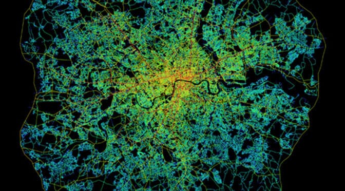
Early space syntax studies demonstrated the potential of the axial map to reveal important functional characteristics about the urban spatial network. This is because urban space tends to be linear with streets, boulevards, avenues, and alleys but with only occasional (in relative terms) convex elements such as squares and public open space (Hillier, 2005). This can been seen most clearly in axial map of Greater London within the M25 (see below). The axial map represents the most optimal line of sight passing through every accessible space in the London street network until accounting for all accessible spaces and, then, measuring and graphically representing the spatial configuration of that network in terms of topological depth (see Space Syntax for Dummies, Part 2). Penn et al (1997) define the axial map as “the minimal set of axial lines such that the set taken together fully surveys the system, and that every axial line that may connect two otherwise-unconnected lines is included” (Turner et al, 2004: 428).
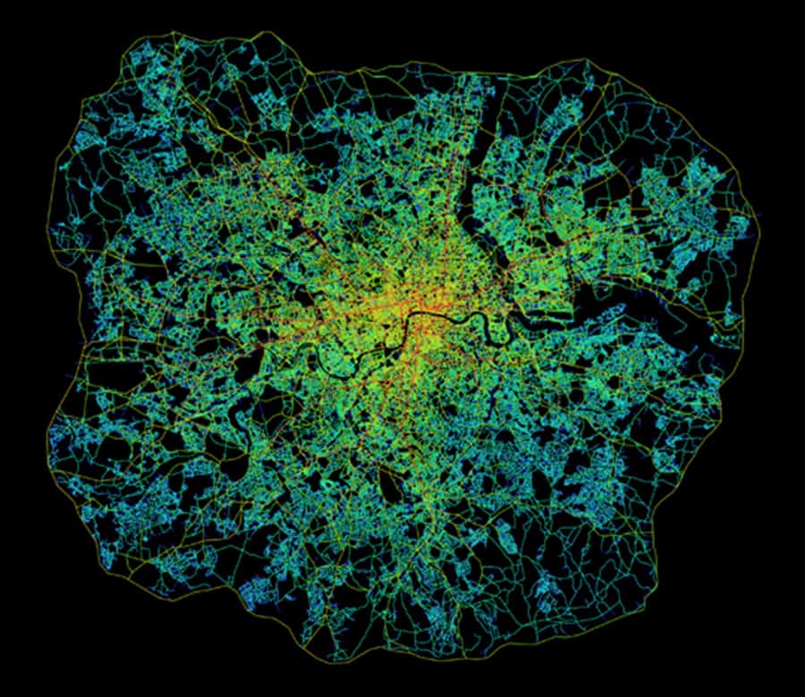
Space syntax model of Greater London within the M25 (Source: Space Syntax Limited and University College London).

Topological depth (refer back to the explanation in Space Syntax for Dummies, Part 2) can be measured based on global integration (or in topological terms, betweenness) because it measures the configurational relationship of all spaces to all others across the entire spatial network. It can also be measured to provide a more localized picture of spatial configuration by measuring local integration (or in topological terms, choice). The latter can be most easily understood if you imagine yourself standing at the intersection of two streets. Simultaneously, you are in and can see along the length of these two streets but also see all other streets – as well as other urban functions, i.e. level of use by people and cars, land uses, building heights. etc. – intersecting with them from your position. Or, topological depth can be measured in terms of radii between these two extremes. The space syntax model of Greater London within the M25 (see above) does so by limiting the radius based on the mean depth from the most globally integrated street; in this case, Oxford Street. The space syntax software automatically colors the degree of integration for each axial line. The color range is from red (most integrated) through orange, yellow, and blue, light blue, blue to purple (most segregated). At this point, the space syntax model is still a purely mathematical representation of configurational pattern. The analysis did not yet take in account other urban functions such as land use, building heights or population density though, of course, this information can be inputted into the model using GIS. Despite this, the axial map appears to provide a very realistic picture of how London operates as an urban spatial network.

An early key finding of space syntax research was establishing there is a relationship between the spatial configuration of the urban grid and patterns of pedestrian and vehicular movement (Hillier et al, 1993; Penn and Hillier, 1998). Penn and Hillier (1998) found that integrated spaces carry larger movement flows than more segregated ones, and the effects were strong and consistent. The key discovery was the correlation between movement flows and a purely configurational measure of the urban spatial network before ever taking into account the location of attractors or generators of movement. This led to the formulation of the theory of natural movement. The theory of natural movement states that movement patterns in the urban environment arise naturally from the way the urban grid organizes the simplest routes to and from all locations involving the fewest changes of changes in that grid. This means it is the design of the urban pattern in the shape of its grid that most matters. In this sense, natural movement is akin to a background effect of the urban grid since most movement in space will tend to be through-movement that is passing through a space on its way to somewhere else in the urban grid. The distribution of activities and land uses then has the potential to further intensify, or detract from, the background effects of natural movement (Hillier, 1996; Hillier and Vaughan, 2007).
A fundamental concept to arise from the theory of natural movement is the city as a movement economy. Namely, it is the pattern of the spatial network as generated by the urban grid, rather than the traditional planning emphasis on origin and destination matrices, which is the fundamental thing about the functioning of cities (Hillier, 1996). The urban grid generates a probabilistic but predictable pattern to the way people move through and occupy spaces in cities. Some spaces receive more movement and use because they are shallower within the spatial network whereas others are deeper and receive less. The spatial configuration of the urban grid generates a pattern of “attraction inequalities” whereby land uses tend to locate to exploit these potentials based on the pattern of natural movement (Hillier, 2002; 154). Retail will occupy more strategic locations to capitalize on the potential for passing trade. According to Hillier (2005), “this is not… to deny attraction… it is common sense (that) people make trips because the shops are there… but (attraction) is not fundamental” (11).

This early finding has led to a considerable body of research on how people move and occupy space, and the relationship to spatial configuration (see below and compare to the space syntax model of the Tate Gallery, Millbank in Space Syntax for Dummies, Part 1).
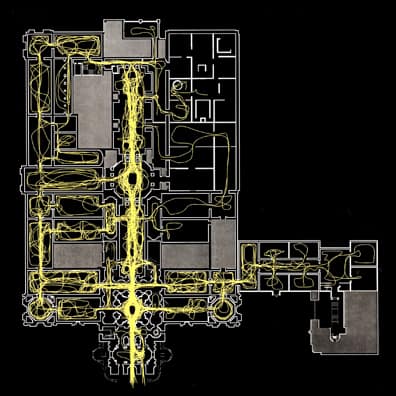
Routes of 100 people during the first 10 minutes of their visit to the Tate Gallery, Millbank (Hillier, et. al., 1996).

This simple introduction on The Outlaw Urbanist only begins to scratch the surface of the volume of research available from the use of space syntax over the previous 30 years. However, it should provide you with a solid foundation to jump into this vast collection of research, most of which is freely available online. For example, more than 500 research papers composing the proceedings of every Space Syntax Symposia for nearly twenty years is freely available for download via the Space Syntax Network here. Also, Chapter 3 of my forthcoming Relentless Magnificence: The American Urban Grid will delve more deeply into space syntax research and issues of methodology/terminology over the last 20 years.

Additional Reading and References
For your convenience, the easiest reading below is indicated with an *asterisk.

Hillier, Bill and L. Vaughan. 2007. “The city as one thing”, Progress in Planning, 67(3): 205-230. Article available online for download from University College London here.

Hillier Bill. 2005. “The art of place and the science of space”, World Architecture, Special Issue on Space Syntax. Beijing: 11(185): 24-34 (in Chinese); 96-102 (in English). Article is currently available online for download via the Scribd here. Registration required.

*Hillier Bill. 2002. “A theory of the city as object: or, how spatial laws mediate the social construction of urban space”, Urban Design International, 7: 153–179. Article available online for download from the Nordic Urban Design Association here.

*Hillier, Bill. 1996. Space is the Machine: A Configurational Theory of Architecture. Cambridge: Cambridge University Press. Digital eBook is available for free download from University College London here.

*Hillier, Bill, M.D. Major, J. Desyllas, K. Karimi, B. Campos, T. Stonor. 1996. Tate Gallery, Millbank: A Study of the Existing Layout and New Masterplan Proposal. Technical Report, Unit For Architectural Studies, Bartlett School of Graduate Studies, University College London. Report is available for free download from University College London here.

*Hillier, Bill, A. Penn, J. Hanson, T. Grajewski, J. Xu. 1993. “Natural Movement: or, configuration and attraction in urban pedestrian movement”, Environment and Planning B: Planning and Design, 20: 29-66. Article available online for download from University College London here.

*Major, M.D. 2014. Relentless Magnificence: The American Urban Grid. Jacksonville, Florida: Forum Books, forthcoming.

Penn, Alan, B. Hillier, D. Banister, Xu, J. 1998. “Configurational modeling of urban movement networks”, Environment and Planning B: Planning and Design, 25: 59-84. Article available online for download from University College London here.

Turner, Alasdair. 2004. Depthmap 4: A Researcher’s Handbook. Bartlett School of Graduate Studies, UCL, London. Handbook available online for download from University College London here.

Share the knowledge!
Share

Space Syntax for Dummies | Part 2 | Basics

Space Syntax for Dummies | Part 2
BASICS
by Dr. Mark David Major, AICP, CNU-A, The Outlaw Urbanist contributor

Continuing our three-part series on the basics of space syntax, Part 2 is based on excerpts from Chapter 3 of my forthcoming Relentless Magnificence: The American Urban Grid. As such, it is somewhat tailored to an American audience. The key principles discussed here are representation and configuration. What is configuration? In the simplest terms, using the most convenient definitions, configuration is not how one thing relates to another thing but how that one thing relates to all other things and also how all those other things relate to each other.

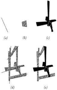
Basic representations of space syntax: (a) axial line; (b) convex space; (c) visual field or an “isovist” (after Benedikt, 1979); or used in tandem (d) axial lines passing through convex spaces; and (e) isovist from a convex space.

According to space syntax theory, a key to understanding urban space is a description not just of the individual elements in the city (this street or that square) but a description of the entire spatial system considered as a configurational network. Over the last three decades, spaces syntax research programs around the world have developed a series of representational and analytical techniques based on simple descriptions of space (Hillier and Hanson, 1984; Hillier, 1996; Hanson, 1998). By simple description, we mean representations that obey real physical constraints the built environment places on visibility and movement since you cannot see and move through solid objects but only through open and accessible space. First, the movement of a person or persons through the built environment tends to be linear so one representation used is the axial line or axis (see ‘a’ above). The matrix of the longest and fewest lines of sight and access that completely encompasses all the spaces of a built environment is the axial map. Second, previous research has found the occupation of space by people in the built environment will tend towards convexity, the mathematical definition of all points being visible to all others, such as a group of people gathered in a circle (Hillier et al, 1996; Campos, 1997). This simple description is a convex space (see ‘b’ above). The collection of the fattest two-dimensional lumps of space, or convex spaces, in a built environment is the convex map. Finally, the potential for seeing and moving in the built environment can also form the basis for a simple description of space, which Benedikt (1990) called the isovist or, more simply, the visual field at eye level (see ‘c’ above) (Hillier et al, 1987; Conroy Dalton et al, 2003). An isovist describes all visible and accessible space to which a person or persons might move as defined from a particular point or set of points. Later methodological developments in space syntax allow for the measurement of the configurational relationship of all visual fields from a gridded set of points (or point isovists) to all others in a built environment. These form a matrix of visual fields where some are more strategic than others for understanding the spatial network as a whole (see the space syntax model of visual fields in the Tate Gallery, Millbank in Space Syntax for Dummies, Part 1). This is a visibility graph (Turner and Penn, 1999). Finally, any combination of these representations can be used to create a more complex picture of the built environment, depending on the problem researched (see ‘d-e’ above). Hillier (2005) describes these simple descriptions as “a natural and necessary spatial geometry (which) describes some aspect of how buildings and cities are organized… as a vital aspect of how we create them, use them and understand them” (5). This is how to represent space.

However, some additional clarification is required about what is meant by configuration. Configuration is a relational system based on topological graph theory whereby any local changes in that system can have global effects across that system (Hillier, 1993; Hillier, 1996).

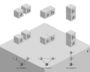
Configuration: (top) Relation between two objects so ‘a’ is to ‘b’ as ‘b’ is to ‘a’; (bottom left) A configurational relationship is created in relation to a third object, such as the surface of the Earth; (bottom center) Connection or permeability changes the configurational relationship between the three objects so all are equally shallow from the other; or, (bottom right) an asymmetrical relationship between the three objects whereby ‘b’ or ‘c’ can only be reached via ‘a.’

For example, two objects are in a mathematical relationship to each other so it can be said that ‘a’ is to ‘b’ as ‘b’ is to ‘a’ (see above, top). Once this relationship is established with reference to a third object, in this case the surface of the earth, there is a configurational relationship (see above, bottom). If the objects are distinct, then it can be said ‘a’ is to ‘c’ as ‘b’ is to ‘c’ but, in order to reach ‘a’ from ‘b’ or vice versa, one has to pass through ‘c’. This can be seen more clearly in the corresponding topological graph where ‘c’ is shallower to ‘a’ and ‘b’ than they are to each other. The depth of ‘a’ or ‘b’ to any other object in the system is three whereas the depth from ‘c’ to ‘a’ or ‘b’ is two and total depth in the system of objects is eight. Next, ‘a’ and ‘b’ can be placed next to each other to introduce the idea of permeability or connection into the system of objects. The objects are in a symmetrical relationship where all spaces are maximally shallow from each other, so that ‘a’ is to ‘b’ as ‘b’ is to ‘c.’ In this case, the depth from any object to any other is two and total depth in the system is six. Finally, if ‘b’ is placed on top of ‘a’, this forms an asymmetrical relationship with reference to ‘c.’ You have to pass through ‘a’ in order to reach ‘b’ from ‘c’ or vice versa but you are not required to pass through ‘b’ to go from ‘c’ to ‘a.’ In this case, the depth of ‘b’ and ‘c’ is three and depth from ‘a’ is only two. Total depth in this asymmetrical relationship is eight (Major, 2000). According to Hillier (2005), “space syntax seeks to formulate mathematically the configurational properties of space that we intuit, as manifested in the way… we construct real spatial patterns through building and cities” using topological graph theory to objectively measure these spatial patterns (6).

These are the basic principles underlying space syntax.

Additional Reading and References
For your convenience, the easiest reading below is indicated with an *asterisk.

Benedikt, Michael L. 1979. “To take hold of space: Isovists and Isovists Fields”, Environment and Planning B: Planning and Design, 6: 47-66. Article is currently available online for download from the Massachusetts Institute of Technology here.

Campos, Maria Beatriz de Arruda. 1997. “Strategic Space: Patterns of Use in Public Square of the City of London”, First International Space Syntax Symposium Proceedings (Eds. M.D. Major, L. Amorim, F. Dufaux), 2: 26.1-26.11. Article is currently available online for download via the Space Syntax Network here.

Conroy Dalton, Ruth and S. Bafna. 2003. “The syntactical image of the city: A reciprocal definition of spatial elements and spatial syntaxes”, Fourth International Space Syntax Symposium Proceedings, London, 2003: 59.1-59.22. Article is currently available online for download via the Space Syntax Network here.

Hanson, Julienne. 1998. Decoding Homes and Houses. Cambridge: Cambridge University Press. Available for purchase from Amazon here.

Hillier Bill. 2005. “The art of place and the science of space”, World Architecture, Special Issue on Space Syntax. Beijing: 11(185): 24-34 (in Chinese); 96-102 (in English). Article is currently available online for download from Scribd here. Registration required.

*Hillier, Bill. 1996. Space is the Machine: A Configurational Theory of Architecture. Cambridge: Cambridge University Press. Digital eBook is available for free download from University College London here.
*Hillier, Bill, M.D. Major, J. Desyllas, K. Karimi, B. Campos, T. Stonor. 1996. Tate Gallery, Millbank: A Study of the Existing Layout and New Masterplan Proposal. Technical Report, Unit For Architectural Studies, Bartlett School of Graduate Studies, University College London. Report is available for free download from University College London here.
*Hiller, Bill, J. Hanson, H. Graham. 1987. “Ideas are in things: an application of space syntax method to discovering housing genotypes”, Environment and Planning D: Planning and Design, 14: 363-385. Article is available for free download from University College London here.

Hillier, Bill and J. Hanson. 1984. The Social Logic of Space. Cambridge: Cambridge University Press. Available for purchase from Amazon here.

*Major, M.D. 2014. Relentless Magnificence: The American Urban Grid. Jacksonville, Florida: Forum Books, forthcoming.

Turner, Alasdair and A. Penn. 1999. “Making Isovists Syntactic: isovist integration analysis”, Second International Space Syntax Symposium Proceedings (Eds. F. de Holanda, L. Amorim, F. Dufaux), 1:11.01-11.14. Article is currently available online for download via the Space Syntax Network here.

Stay tuned for Space Syntax for Dummies, Part 3: Results.

Share the knowledge!
Share

Space Syntax for Dummies | Part 1 | Overview

Space Syntax for Dummies | Part 1
OVERVIEW
by Dr. Mark David Major, AICP, CNU-A, The Outlaw Urbanist contributor

A couple of months ago, Steve Mouzon (author of The Original Green and New Media for Designers + Builders) asked me to write an easy-to-understand introduction to space syntax on The Outlaw Urbanist. I don’t think he actually used the words ‘space syntax for dummies’ but it’s a good title (and a purposefully provocative one), so I’m running with it. There is a lot of material available in print and online about space syntax. However, for someone unfamiliar with the principles of space syntax, it can be a daunting prospect deciding where to begin when there are 30 years of material freely available from multiple sources. If you don’t chose wisely, there’s the very real risk of accidentally diving into the deep end before getting your feet wet in the shallow waters of the space syntax pool.

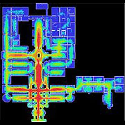
Space Syntax model of floor plan in the Tate Gallery, Millbank in London, UK (Image: Space Syntax Network).

When I say 30 years, I mark the beginnings of widespread space syntax research from the publication date of The Social Logic of Space by Bill Hillier and Julienne Hanson. However, there were about 10 years of groundwork involving many people preceding its publication in 1984. For example, the 40th Anniversary celebrations of the MSc in Advanced Architectural Studies course at University College London (of which I am a graduate and former Course Director) occurred this year and one can easily mark the beginnings of space syntax using this date. In the past, Bill Hillier has referred to me as the founder of International Space Syntax Symposia (now approaching its 20th anniversary) and, while that is generally true, like all things space syntax it was really a collaborative genesis involving myself, Tim Stonor and several others. The fact is I haven’t attended an International Space Syntax Symposium since the second one in Brasilia, Brazil (I was scheduled to present a paper at the third symposium in Atlanta in 2001 but was unable to attend though my paper on Savannah was still included in the proceedings).

What follows – I hope – is a simple, three-part introduction for those totally unfamiliar or only vaguely familiar with space syntax. For those familiar with space syntax (including its practitioners), this introduction will most likely be boring (perhaps in the extreme). Along the way, I will direct readers to other useful resources and additional reading if they want to learn more.

Part 1 draws upon home page of the Space Syntax Network, which provides a simple and direct 10,000-foot overview of space syntax (3,048-meters for those on the metric system) without getting too much into the details. It also includes a short, informative introduction video (embedded below) featuring Professor Alan Penn. Part 2 (Basics) and Part 3 (Results) draw upon distilled excerpts from the space syntax overview chapter of my forthcoming book, Relentless Magnificence: The American Urban Grid. As such, this means Space Syntax for Dummies is primarily intended for an American audience though I hope readers in other parts of the world will still find it useful.

Because space syntax is such a collaborative research program (remarkably so, in my opinion), Space Syntax for Dummies synthesizes the ideas and words of others over the last three decades as well as using my own words for introducing space syntax to a new audience. It would be almost impossible to compile an exhaustive list of people contributing to space syntax over this time period – and this introduction, in particular – but certainly the most important to cite are Bill Hillier, Julienne Hanson, Alan Penn, Tim Stonor, John Peponis, Nick “Sheep” Dalton, and Alasdair Turner.
Excerpt from the Space Syntax Network:

Space syntax is a science-based, human-focused approach that investigates relationships between spatial layout and a range of social, economic and environmental phenomena. These phenomena include patterns of movement, awareness and interaction; density, land use and land value; urban growth and societal differentiation; safety and crime distribution.

Space syntax was pioneered in the 1970s by Professor Bill Hillier, Prof Julienne Hanson and colleagues at The Bartlett, University College London. Today, space syntax is used and developed in hundreds of universities and educational institutions as well as professional practices worldwide. Built on quantitative analysis and geospatial computer technology, space syntax provides a set of theories and methods for the analysis of spatial configurations of all kinds and at all scales.

Research using the space syntax approach has shown how:

– movement patterns are powerfully shaped by spatial layout

– patterns of security and insecurity are affected by spatial design

– this relation shapes the evolution of the centres and sub-centres that makes cities liveable

– spatial segregation and social disadvantage are related in cities

– buildings can create more interactive organisational cultures.

Watch the UCL introduction video featuring Professor Alan Penn below:

Read the full article here: Space Syntax Network.

Additional resources: Tim Stonor’s blog, The Power of the Network, is a good resource for reading about the ideas and findings of space syntax expressed in layman’s terms without getting blogged down in the nitty gritty details of the research behind the words.

Stay tuned for Space Syntax for Dummies, Part 2: Basics!

Share the knowledge!
Share

Havana, Cuba | An Illustrative History

Havana, Cuba | An Illustrative History

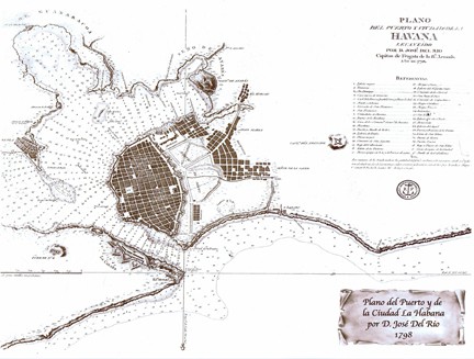
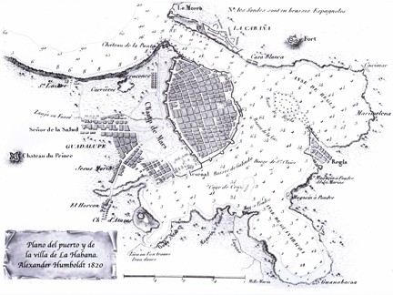
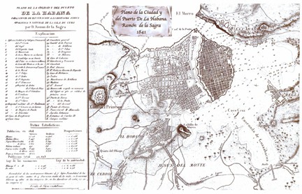
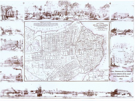
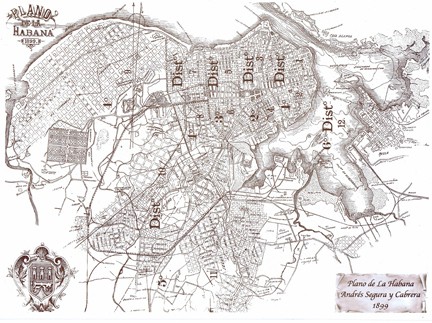
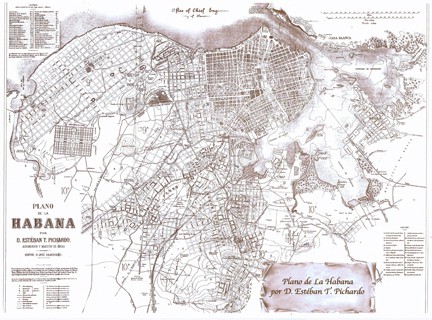
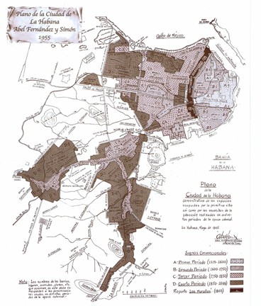
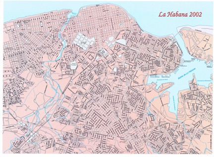
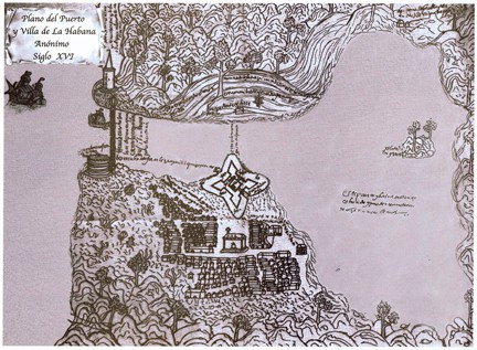
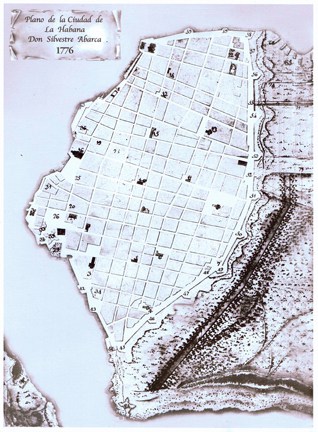
An illustrative history of town plans for Havana, Cuba sent to The Outlaw Urbanist, courtesy of Concrete Blonde.

Earliest drawing of town plan for Havana, Cuba from the 16th century.
1776 Plan of Havana, Cuba.
1798 Plan of Havana, Cuba
1820 Plan of Havana, Cuba
1841 Plan of Havana, Cuba
1855 Plan of Havana, Cuba.
1899 Plan of Havana, Cuba.
1900 Plan of Havana, Cuba.
1955 illustration of phrased growth in Havana, Cuba from 1519 to dawn of the 20th century.
2002 Plan of Havana, Cuba.

All maps copyrighted © Ediciones GEO, 2002, Havana, Cuba.

Share the knowledge!
Share

Urban Patterns | Nuuk, Greenland

“Look around, leaves are brown
And the sky is a hazy shade of winter.”
— Hazy Shade of Winter, Simon & Garfunkel
Admit it: most of us prefer the 1987 version by The Bangles.

Urban Patterns | Nuuk, Greenland
by Dr. Mark David Major, AICP, CNU-A

NOTE: Urban Patterns is focusing on more obscure and/or extreme locations in a number of posts over the next few weeks.

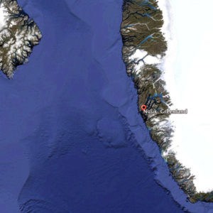
Satellite view of Nuuk on the southwest coast of Greenland from 800 km (Image: US Geological Survey, Landsat and IBCAO, Data SIO, NOAA, U.S. Navy, NGA, GEBCO, courtesy of Google Earth, 2013). The north coast of Baffin Island, Canada is to the extreme left of this image.

Nuuk, Greenland is the capital city of Greenland. It is located at the end of the Nuup Kangerlua fjord on the eastern shore of the Labrador Sea. The area around Nuuk has a long history of habitation dating as far back to 2,200 BC including the ancient pre-Inuit, Vikings/Norse, Norwegian, and Danish people. The colony founded in 1728 by the Dano-Norwegian Crown consisted of mutinous soldiers, convicts, and prostitutes; most of whom died within the first year of scurvy and other ailments. Today, it has a population of approximately 16,500 people and over a third of Greenland’s total population lives in the Nuuk Greater Metropolitan area. The town has steadily grown over the last two decades with the population increasing by over a third relative to the 1990 levels, and by over 22% relative to the 2000 levels. Nuuk has developed trade, business, shipping, and other industries. It began as a small fishing settlement with a harbor but, as the economy developed rapidly during the 1970s and 1980s, the fishing industry declined. However, seafood including fish, seal, and so forth is still sold in abundance in Nuuk and the capital contains a number of fish markets. Minerals such as zinc, gold, and so forth have significantly contributed to the development of Nuuk’s economy. The city, like much of Greenland, is heavily dependent upon Danish funding and investment (Source: Wikipedia).

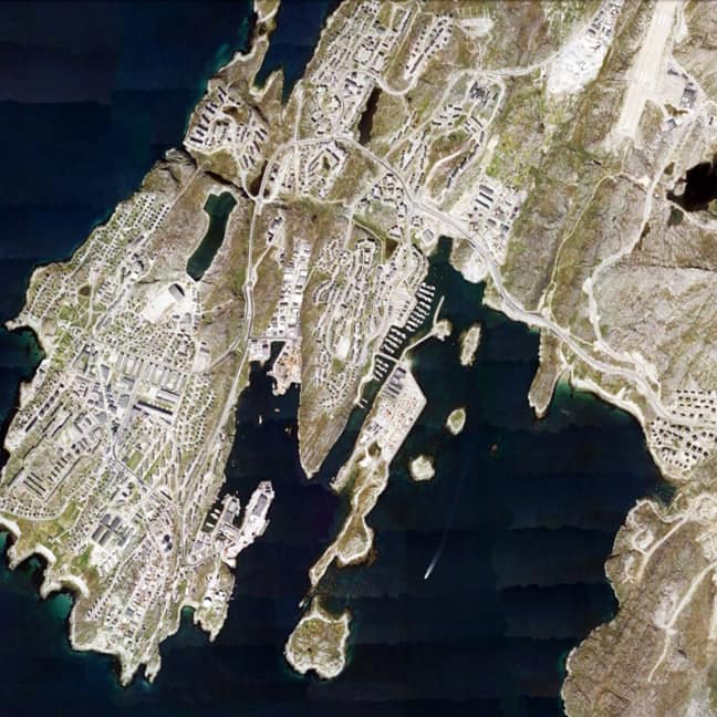
Satellite view from 10km of Nuuk, Greenland in 2013 (Source: Google Earth).

The urban grid of Nuuk is somewhat unexpected. Given the extreme polar climate, one might expect a more compact layout to promote energy and heat efficiency in the settlement. However, the town has more of a dispersed deformed grid layout, perhaps somewhat more characteristic of Inuit settlements in the horizontal dimension whilst much of the architecture reflects a Danish/European influence in the vertical dimension (see the header image). The dispersed nature of the urban grid might also be reflective of the rapid growth occurring in the town over the previous three decades. Some areas of the urban grid are laid out in a manner consistent with American suburban sprawl patterns, especially to the east and north of the town. The somewhat hilly terrain of the town probably plays a role in this settlement form as well. Given its location in Greenland, several things about Nuuk might, at first glance, strike some people as odd: for example, Nuuk has its own golf club and course,  which is adjacent to the University of Greenland campus (yes, there is a university but only 150 students); there is the Greenland National Museum, a National Library, and a Greenland National Bank; and, even two stadia located in the town, a futbol stadium with a seating capacity of 2,000 people and a handball stadium that can hold 1,000 people. Nuuk, Greenland is so unexpected in many ways, which it is utterly fascinating.

(Updated: July 4, 2017)

Urban Patterns is a series of posts from The Outlaw Urbanist presenting interesting examples of terrestrial patterns shaped by human intervention in the urban landscape over time.

Share the knowledge!
Share